![](/images/other/stat-length.png)
![Randonnée Marche Saint-Martin-la-Plaine - rando autour de St Martin la plaine, - Photo](https://media.geolcdn.com/t/1900/400/edbc12e4-5772-4b73-9ba2-a3d81bfb5c32.jpg&format=pjpeg&maxdim=2)
rando autour de St Martin la plaine,
mimi69670
Utilisateur
![Longueur](/images/other/stat-length.png)
Longueur
10,4 km
![Altitude max](https://static1.geolcdn.com/siteimages/upload/files/1508320355ic_sort_altitude_max_24dp.png)
Altitude max
606 m
![Dénivelé positif](https://static1.geolcdn.com/siteimages/upload/files/1508320355ic_sort_den_pos_24dp.png)
Dénivelé positif
237 m
![Km-Effort](/images/other/stat-length.png)
Km-Effort
13,6 km
![Altitude min](https://static1.geolcdn.com/siteimages/upload/files/1508320355ic_sort_altitude_min_24dp.png)
Altitude min
424 m
![Dénivelé négatif](https://static1.geolcdn.com/siteimages/upload/files/1508320355ic_sort_den_neg_24dp.png)
Dénivelé négatif
236 m
![Boucle](https://static1.geolcdn.com/siteimages/upload/files/16400158638029165_repeat_loop_refresh_sync_direction_icon.png)
Boucle
Oui
Date de création :
2022-04-09 07:33:35.188
Dernière modification :
2022-04-09 11:02:18.427
![Marche](https://static1.geolcdn.com/sitytour/trail-icons/101.png)
3h06
Difficulté : Facile
![Scannez ce code QR pour ouvrir la randonnée dans l'application SityTrail](https://capi.geolives.com/qq0zvz2zws4bq2lad0pu/sitytour/trails/3197532/qr.png?size=200)
Application GPS de randonnée GRATUITE
À propos
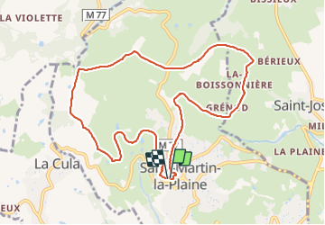
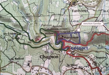
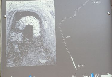
Randonnée Marche de 10,4 km à découvrir à Auvergne-Rhône-Alpes, Loire, Saint-Martin-la-Plaine. Cette randonnée est proposée par mimi69670.
Description
Départ de St Martin la Plaine, grimpez sur les crets et points de vue sur le Pilât et par temps clair, la chaîne des Alpes
Localisation
Pays :
France
Région :
Auvergne-Rhône-Alpes
Département/Province :
Loire
Commune :
Saint-Martin-la-Plaine
Localité :
Unknown
Départ:(Dec)
Départ:(UTM)
624175 ; 5044856 (31T) N.
Commentaires
Randonnées à proximité
![Randonnée Marche La Grand-Croix - MOYENNE MARCHE - Photo](https://media.geolcdn.com/t/375/260/ext.jpg?maxdim=2&url=https%3A%2F%2Fstatic1.geolcdn.com%2Fsiteimages%2Fupload%2Ffiles%2F1553511878bg_sport_marche.png)
![Marche Marche](https://static1.geolcdn.com/sitytour/trail-icons/101.png)
MOYENNE MARCHE
Marche
Très facile
(1)
La Grand-Croix,
Auvergne-Rhône-Alpes,
Loire,
France
![](/images/other/stat-length.png)
3,8 km | 5 km-effort
1h 1min
![](https://static1.geolcdn.com/siteimages/upload/files/16400158638029165_repeat_loop_refresh_sync_direction_icon.png)
Oui
![Randonnée Marche Chagnon - 42_Chagnon_13km470m - Photo](https://media.geolcdn.com/t/375/260/7ea874cc-cd00-4c8f-a5f4-5d79cdc17a88.jpg&format=jpg&maxdim=2)
![Marche Marche](https://static1.geolcdn.com/sitytour/trail-icons/101.png)
42_Chagnon_13km470m
Marche
Moyen
Chagnon,
Auvergne-Rhône-Alpes,
Loire,
France
![](/images/other/stat-length.png)
13,1 km | 19,3 km-effort
2h 58min
![](https://static1.geolcdn.com/siteimages/upload/files/16400158638029165_repeat_loop_refresh_sync_direction_icon.png)
Oui
![Randonnée Marche Saint-Joseph - 42-st-joseph-10km-320m - Photo](https://media.geolcdn.com/t/375/260/d6018596-5a38-4194-9525-041abab6ce05.jpg&format=jpg&maxdim=2)
![Marche Marche](https://static1.geolcdn.com/sitytour/trail-icons/101.png)
42-st-joseph-10km-320m
Marche
Facile
Saint-Joseph,
Auvergne-Rhône-Alpes,
Loire,
France
![](/images/other/stat-length.png)
10,5 km | 14,8 km-effort
2h 50min
![](https://static1.geolcdn.com/siteimages/upload/files/16400158638029165_repeat_loop_refresh_sync_direction_icon.png)
Oui
![Randonnée Marche Chabanière - 69-st-maurice-dargoire2-19km-580m - Photo](https://media.geolcdn.com/t/375/260/c4b20fd4-ad58-4836-9971-2020b70efe6f.jpg&format=jpg&maxdim=2)
![Marche Marche](https://static1.geolcdn.com/sitytour/trail-icons/101.png)
69-st-maurice-dargoire2-19km-580m
Marche
Difficile
Chabanière,
Auvergne-Rhône-Alpes,
Rhône,
France
![](/images/other/stat-length.png)
19,2 km | 27 km-effort
5h 47min
![](https://static1.geolcdn.com/siteimages/upload/files/16400158638029165_repeat_loop_refresh_sync_direction_icon.png)
Oui
![Randonnée Marche Chabanière - 69_st_maurice_dargeoire_12km_300m - Photo](https://media.geolcdn.com/t/375/260/83f5b7e0-e7a1-44e9-9c6c-d04e1b215358.jpg&format=jpg&maxdim=2)
![Marche Marche](https://static1.geolcdn.com/sitytour/trail-icons/101.png)
69_st_maurice_dargeoire_12km_300m
Marche
Moyen
Chabanière,
Auvergne-Rhône-Alpes,
Rhône,
France
![](/images/other/stat-length.png)
11,6 km | 15,5 km-effort
3h 31min
![](https://static1.geolcdn.com/siteimages/upload/files/16400158638029165_repeat_loop_refresh_sync_direction_icon.png)
Oui
![Randonnée Marche Saint-Martin-la-Plaine - 42-martinlaplaine-12km450m - Photo](https://media.geolcdn.com/t/375/260/0bbcbe3d-ff1f-4c48-95ef-874625509cfa.jpg&format=jpg&maxdim=2)
![Marche Marche](https://static1.geolcdn.com/sitytour/trail-icons/101.png)
42-martinlaplaine-12km450m
Marche
Difficile
Saint-Martin-la-Plaine,
Auvergne-Rhône-Alpes,
Loire,
France
![](/images/other/stat-length.png)
12,9 km | 18,9 km-effort
4h 17min
![](https://static1.geolcdn.com/siteimages/upload/files/16400158638029165_repeat_loop_refresh_sync_direction_icon.png)
Oui
![Randonnée Marche Cellieu - Cellier Valfleurie - Photo](https://media.geolcdn.com/t/375/260/ddbd041f-9f5b-41f8-ae6c-ee02ff5e9afa.jpg&format=jpg&maxdim=2)
![Marche Marche](https://static1.geolcdn.com/sitytour/trail-icons/101.png)
Cellier Valfleurie
Marche
Moyen
Cellieu,
Auvergne-Rhône-Alpes,
Loire,
France
![](/images/other/stat-length.png)
19,3 km | 29 km-effort
4h 37min
![](https://static1.geolcdn.com/siteimages/upload/files/16400158638029165_repeat_loop_refresh_sync_direction_icon.png)
Non
![Randonnée Marche Cellieu - cellieu partiel pournphotos - Photo](https://media.geolcdn.com/t/375/260/fee08f5c-9bca-4082-bdf2-49f590ea9fc1.jpg&format=jpg&maxdim=2)
![Marche Marche](https://static1.geolcdn.com/sitytour/trail-icons/101.png)
cellieu partiel pournphotos
Marche
Moyen
Cellieu,
Auvergne-Rhône-Alpes,
Loire,
France
![](/images/other/stat-length.png)
11 km | 17,9 km-effort
2h 37min
![](https://static1.geolcdn.com/siteimages/upload/files/16400158638029165_repeat_loop_refresh_sync_direction_icon.png)
Non
![Randonnée Marche Cellieu - Cellieu - Photo](https://media.geolcdn.com/t/375/260/ext.jpg?maxdim=2&url=https%3A%2F%2Fstatic1.geolcdn.com%2Fsiteimages%2Fupload%2Ffiles%2F1553511878bg_sport_marche.png)
![Marche Marche](https://static1.geolcdn.com/sitytour/trail-icons/101.png)
Cellieu
Marche
Moyen
(1)
Cellieu,
Auvergne-Rhône-Alpes,
Loire,
France
![](/images/other/stat-length.png)
19,2 km | 28 km-effort
6h 29min
![](https://static1.geolcdn.com/siteimages/upload/files/16400158638029165_repeat_loop_refresh_sync_direction_icon.png)
Oui