![](/images/other/stat-length.png)
![Randonnée Trail Noyers-sur-Jabron - Crête de l'Ane - Photo](https://media.geolcdn.com/t/1900/400/ext.pjpeg?maxdim=2&url=https%3A%2F%2Fstatic1.geolcdn.com%2Fsiteimages%2Fupload%2Ffiles%2F1524743154running.jpg)
Crête de l'Ane
phd04
Utilisateur
![Longueur](/images/other/stat-length.png)
![Altitude max](https://static1.geolcdn.com/siteimages/upload/files/1508320355ic_sort_altitude_max_24dp.png)
![Dénivelé positif](https://static1.geolcdn.com/siteimages/upload/files/1508320355ic_sort_den_pos_24dp.png)
![Km-Effort](/images/other/stat-length.png)
![Altitude min](https://static1.geolcdn.com/siteimages/upload/files/1508320355ic_sort_altitude_min_24dp.png)
![Dénivelé négatif](https://static1.geolcdn.com/siteimages/upload/files/1508320355ic_sort_den_neg_24dp.png)
![Boucle](https://static1.geolcdn.com/siteimages/upload/files/16400158638029165_repeat_loop_refresh_sync_direction_icon.png)
![Trail](https://static1.geolcdn.com/sitytour/trail-icons/104.png)
0m
Difficulté : Difficile
![Scannez ce code QR pour ouvrir la randonnée dans l'application SityTrail](https://capi.geolives.com/qq0zvz2zws4bq2lad0pu/sitytour/trails/3195451/qr.png?size=200)
Application GPS de randonnée GRATUITE
À propos
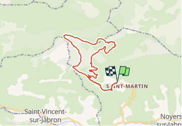
Randonnée Trail de 17,6 km à découvrir à Provence-Alpes-Côte d'Azur, Alpes-de-Haute-Provence, Noyers-sur-Jabron. Cette randonnée est proposée par phd04.
Description
De St Martin prendre le GR 946 (route forestière) jusqu'au Col S Pierre (vous pouvez aussi passer par le gîte de Couais). Du panneau d'indication prendre la direction de Ribiers. La pente est rude pour arriver au sommet de la Crête. La descente jusqu'au Col de Blauge est abrupte et technique. Suivre le GR de Pays, jusqu'au panneau situé en dessus de la Bergerie Taxil. Prendre Col de Couais que vous atteindrez après 3 km. De là descendre pour rejoindre le GR 946 jusqu'à St Martin.
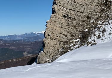
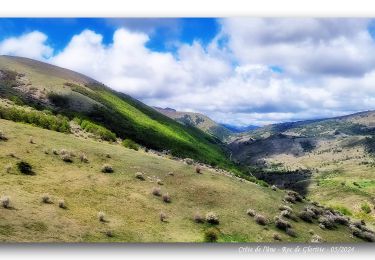
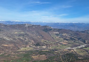
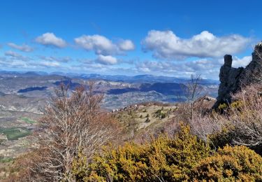
Très belle rando-trail à faire par beau temps, car du sommet de la Crête de l’Âne, on a une vue magnifique.
Localisation
Commentaires
Randonnées à proximité
![Randonnée Marche Saint-Vincent-sur-Jabron - SAINT VINCENT DU JABRON . Aubard , vieux Curel , chateau des Graves o l s - Photo](https://media.geolcdn.com/t/375/260/224a29dc-57ab-4460-b161-8fc4759a6807.jpg&format=jpg&maxdim=2)
![Marche Marche](https://static1.geolcdn.com/sitytour/trail-icons/101.png)
Marche
![](/images/other/stat-length.png)
![](https://static1.geolcdn.com/siteimages/upload/files/16400158638029165_repeat_loop_refresh_sync_direction_icon.png)
![Randonnée Marche Saint-Vincent-sur-Jabron - 2024-10-13 Saint Vincent sur Jabron- Pas de Parandier - Photo](https://media.geolcdn.com/t/375/260/c705e38e-601a-4854-bd06-f75f3efcc7e8.jpg&format=jpg&maxdim=2)
![Marche Marche](https://static1.geolcdn.com/sitytour/trail-icons/101.png)
Marche
![](/images/other/stat-length.png)
![](https://static1.geolcdn.com/siteimages/upload/files/16400158638029165_repeat_loop_refresh_sync_direction_icon.png)
![Randonnée Marche Noyers-sur-Jabron - Noyers sur Jabron - Crête de l'Ane - Photo](https://media.geolcdn.com/t/375/260/b5b69900-a4cf-40a0-8395-e0fe0112d265.jpg&format=jpg&maxdim=2)
![Marche Marche](https://static1.geolcdn.com/sitytour/trail-icons/101.png)
Marche
![](/images/other/stat-length.png)
![](https://static1.geolcdn.com/siteimages/upload/files/16400158638029165_repeat_loop_refresh_sync_direction_icon.png)
![Randonnée Marche Saint-Vincent-sur-Jabron - SAINT VINCENT DU JABRON. Aubard, col de Verdun , le pied du mulet o l m s - Photo](https://media.geolcdn.com/t/375/260/9bf08486-a2a4-4953-a4bf-9ce23f6d6e8d.jpg&format=jpg&maxdim=2)
![Marche Marche](https://static1.geolcdn.com/sitytour/trail-icons/101.png)
Marche
![](/images/other/stat-length.png)
![](https://static1.geolcdn.com/siteimages/upload/files/16400158638029165_repeat_loop_refresh_sync_direction_icon.png)
![Randonnée Marche Saint-Vincent-sur-Jabron - SAINT VINCENT SUR JABRON. Pas de Parandier ,montagne S Michel o n - Photo](https://media.geolcdn.com/t/375/260/05bd1fc9-c51a-44b4-a53f-1799b3b164e7.jpg&format=jpg&maxdim=2)
![Marche Marche](https://static1.geolcdn.com/sitytour/trail-icons/101.png)
Marche
![](/images/other/stat-length.png)
![](https://static1.geolcdn.com/siteimages/upload/files/16400158638029165_repeat_loop_refresh_sync_direction_icon.png)
![Randonnée Marche Saint-Vincent-sur-Jabron - Rando des Crêtes de Mare (Jabron 02 2025 - Photo](https://media.geolcdn.com/t/375/260/07eb8eef-ead0-4539-8c1f-ea13ee0a71b1.jpg&format=jpg&maxdim=2)
![Marche Marche](https://static1.geolcdn.com/sitytour/trail-icons/101.png)
Marche
![](/images/other/stat-length.png)
![](https://static1.geolcdn.com/siteimages/upload/files/16400158638029165_repeat_loop_refresh_sync_direction_icon.png)
![Randonnée Marche Val-Buëch-Méouge - Crête de l'âne, des Planes et Roc de Gloritte Via Plaugiers - Photo](https://media.geolcdn.com/t/375/260/4d865235-32fc-413e-9d16-081082317d85.jpg&format=jpg&maxdim=2)
![Marche Marche](https://static1.geolcdn.com/sitytour/trail-icons/101.png)
Marche
![](/images/other/stat-length.png)
![](https://static1.geolcdn.com/siteimages/upload/files/16400158638029165_repeat_loop_refresh_sync_direction_icon.png)
![Randonnée Marche Noyers-sur-Jabron - Pas du long Rocher - Montagne de Pélegrine - Pas des portes - Photo](https://media.geolcdn.com/t/375/260/9e465827-c241-4f40-9a13-784ef9be38b0.jpg&format=jpg&maxdim=2)
![Marche Marche](https://static1.geolcdn.com/sitytour/trail-icons/101.png)
Marche
![](/images/other/stat-length.png)
![](https://static1.geolcdn.com/siteimages/upload/files/16400158638029165_repeat_loop_refresh_sync_direction_icon.png)
![Randonnée Marche Saint-Vincent-sur-Jabron - Crête Montagne de Mare Via St Vincent sur Jabron - Photo](https://media.geolcdn.com/t/375/260/1baeea92-ca4d-4ee3-92e8-21a8cf9e9e85.jpg&format=jpg&maxdim=2)
![Marche Marche](https://static1.geolcdn.com/sitytour/trail-icons/101.png)
Marche
![](/images/other/stat-length.png)
![](https://static1.geolcdn.com/siteimages/upload/files/16400158638029165_repeat_loop_refresh_sync_direction_icon.png)