![](/images/other/stat-length.png)
![Randonnée A pied Grisy-Suisnes - J 84 grisy coubert soignolles 11.23 km - Photo](https://media.geolcdn.com/t/1900/400/ext.pjpeg?maxdim=2&url=https%3A%2F%2Fstatic1.geolcdn.com%2Fsiteimages%2Fupload%2Ffiles%2F1545311037marcheuse_200dpi.jpg)
J 84 grisy coubert soignolles 11.23 km
Les 1000 pattes
Club randonnées SERVON
![Longueur](/images/other/stat-length.png)
Longueur
11,2 km
![Altitude max](https://static1.geolcdn.com/siteimages/upload/files/1508320355ic_sort_altitude_max_24dp.png)
Altitude max
99 m
![Dénivelé positif](https://static1.geolcdn.com/siteimages/upload/files/1508320355ic_sort_den_pos_24dp.png)
Dénivelé positif
86 m
![Km-Effort](/images/other/stat-length.png)
Km-Effort
12,4 km
![Altitude min](https://static1.geolcdn.com/siteimages/upload/files/1508320355ic_sort_altitude_min_24dp.png)
Altitude min
57 m
![Dénivelé négatif](https://static1.geolcdn.com/siteimages/upload/files/1508320355ic_sort_den_neg_24dp.png)
Dénivelé négatif
84 m
![Boucle](https://static1.geolcdn.com/siteimages/upload/files/16400158638029165_repeat_loop_refresh_sync_direction_icon.png)
Boucle
Oui
Date de création :
2022-04-07 06:59:34.138
Dernière modification :
2024-03-27 18:19:34.641
![A pied](https://static1.geolcdn.com/sitytour/trail-icons/100.png)
2h48
Difficulté : Facile
![Scannez ce code QR pour ouvrir la randonnée dans l'application SityTrail](https://capi.geolives.com/qq0zvz2zws4bq2lad0pu/sitytour/trails/3195092/qr.png?size=200)
Application GPS de randonnée GRATUITE
À propos
Randonnée A pied de 11,2 km à découvrir à Île-de-France, Seine-et-Marne, Grisy-Suisnes. Cette randonnée est proposée par Les 1000 pattes.
Description
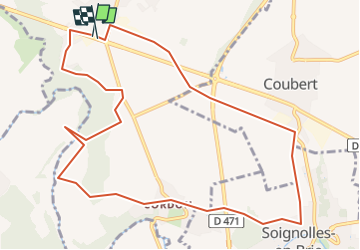
départ de grissy suisnes sur la D319, passage par Suisnes, le prieuré de Vernelles, Cordon, Soignolles, Coubert et retour par le chemin des Roses.
Localisation
Pays :
France
Région :
Île-de-France
Département/Province :
Seine-et-Marne
Commune :
Grisy-Suisnes
Localité :
Unknown
Départ:(Dec)
Départ:(UTM)
475086 ; 5391715 (31U) N.
Commentaires
Randonnées à proximité
![Randonnée Marche Brie-Comte-Robert - brie comte robert - Photo](https://media.geolcdn.com/t/375/260/ext.jpg?maxdim=2&url=https%3A%2F%2Fservices.sitytrail.com%2FGeolivesWS%2FDownloadMedia.ashx%3FTrailID%3D172162%26Media%3D20130130123759.jpeg)
![Marche Marche](https://static1.geolcdn.com/sitytour/trail-icons/101.png)
brie comte robert
Marche
Facile
(2)
Brie-Comte-Robert,
Île-de-France,
Seine-et-Marne,
France
![](/images/other/stat-length.png)
16,7 km | 18,8 km-effort
4h 21min
![](https://static1.geolcdn.com/siteimages/upload/files/16400158638029165_repeat_loop_refresh_sync_direction_icon.png)
Oui
![Randonnée Marche Évry-Grégy-sur-Yerre - J 55 miguelmillepattes Evry Grégy sur Yerres - Prieuré de Vernelle - Photo](https://media.geolcdn.com/t/375/260/ext.jpg?maxdim=2&url=https%3A%2F%2Fmedia.geolcdn.com%2Ff%2F838bff98-2775-4bd0-83b3-89163c602221.jpg)
![Marche Marche](https://static1.geolcdn.com/sitytour/trail-icons/101.png)
J 55 miguelmillepattes Evry Grégy sur Yerres - Prieuré de Vernelle
Marche
Moyen
(2)
Évry-Grégy-sur-Yerre,
Île-de-France,
Seine-et-Marne,
France
![](/images/other/stat-length.png)
11,9 km | 13,6 km-effort
3h 5min
![](https://static1.geolcdn.com/siteimages/upload/files/16400158638029165_repeat_loop_refresh_sync_direction_icon.png)
Oui
![Randonnée Marche Coubert - JC 27 Coubert, Solers cimetière allemand, Prieuré de Vernelle - Photo](https://media.geolcdn.com/t/375/260/ext.jpg?maxdim=2&url=https%3A%2F%2Fmedia.geolcdn.com%2Ff%2Fb6b52968-ca6b-4031-862f-615df2d504ec.jpg)
![Marche Marche](https://static1.geolcdn.com/sitytour/trail-icons/101.png)
JC 27 Coubert, Solers cimetière allemand, Prieuré de Vernelle
Marche
Difficile
(1)
Coubert,
Île-de-France,
Seine-et-Marne,
France
![](/images/other/stat-length.png)
20 km | 23 km-effort
5h 11min
![](https://static1.geolcdn.com/siteimages/upload/files/16400158638029165_repeat_loop_refresh_sync_direction_icon.png)
Oui
![Randonnée A pied Soignolles-en-Brie - L 22 5km gués de Barneau - Photo](https://media.geolcdn.com/t/375/260/ext.jpg?maxdim=2&url=https%3A%2F%2Fmedia.geolcdn.com%2Ff%2Fcef3660d-bb64-4c7a-911e-b5ee4181c187.jpg)
![A pied A pied](https://static1.geolcdn.com/sitytour/trail-icons/100.png)
L 22 5km gués de Barneau
A pied
Très facile
(2)
Soignolles-en-Brie,
Île-de-France,
Seine-et-Marne,
France
![](/images/other/stat-length.png)
5,1 km | 5,9 km-effort
Inconnu
![](https://static1.geolcdn.com/siteimages/upload/files/16400158638029165_repeat_loop_refresh_sync_direction_icon.png)
Oui
![Randonnée Marche Brie-Comte-Robert - AdxBCR13PlaineChvry - Photo](https://media.geolcdn.com/t/375/260/ext.jpg?maxdim=2&url=https%3A%2F%2Fstatic1.geolcdn.com%2Fsiteimages%2Fupload%2Ffiles%2F1553511878bg_sport_marche.png)
![Marche Marche](https://static1.geolcdn.com/sitytour/trail-icons/101.png)
AdxBCR13PlaineChvry
Marche
Difficile
(1)
Brie-Comte-Robert,
Île-de-France,
Seine-et-Marne,
France
![](/images/other/stat-length.png)
13,4 km | 14,1 km-effort
3h 11min
![](https://static1.geolcdn.com/siteimages/upload/files/16400158638029165_repeat_loop_refresh_sync_direction_icon.png)
Oui
![Randonnée Marche Brie-Comte-Robert - AdxBCR13Santenybis - Photo](https://media.geolcdn.com/t/375/260/ext.jpg?maxdim=2&url=https%3A%2F%2Fstatic1.geolcdn.com%2Fsiteimages%2Fupload%2Ffiles%2F1553511878bg_sport_marche.png)
![Marche Marche](https://static1.geolcdn.com/sitytour/trail-icons/101.png)
AdxBCR13Santenybis
Marche
Difficile
(1)
Brie-Comte-Robert,
Île-de-France,
Seine-et-Marne,
France
![](/images/other/stat-length.png)
13,6 km | 14,9 km-effort
3h 23min
![](https://static1.geolcdn.com/siteimages/upload/files/16400158638029165_repeat_loop_refresh_sync_direction_icon.png)
Oui
![Randonnée A pied Évry-Grégy-sur-Yerre - J 55 Evry les Châteaux, le prieuré de Vernelle - Photo](https://media.geolcdn.com/t/375/260/ext.jpg?maxdim=2&url=https%3A%2F%2Fstatic1.geolcdn.com%2Fsiteimages%2Fupload%2Ffiles%2F1545311037marcheuse_200dpi.jpg)
![A pied A pied](https://static1.geolcdn.com/sitytour/trail-icons/100.png)
J 55 Evry les Châteaux, le prieuré de Vernelle
A pied
Facile
(1)
Évry-Grégy-sur-Yerre,
Île-de-France,
Seine-et-Marne,
France
![](/images/other/stat-length.png)
10,8 km | 12,6 km-effort
2h 51min
![](https://static1.geolcdn.com/siteimages/upload/files/16400158638029165_repeat_loop_refresh_sync_direction_icon.png)
Oui
![Randonnée A pied Brie-Comte-Robert - JC 22 Brie, grisy,suisnes,evry les chateaux, grégy - Photo](https://media.geolcdn.com/t/375/260/ext.jpg?maxdim=2&url=https%3A%2F%2Fstatic1.geolcdn.com%2Fsiteimages%2Fupload%2Ffiles%2F1545311037marcheuse_200dpi.jpg)
![A pied A pied](https://static1.geolcdn.com/sitytour/trail-icons/100.png)
JC 22 Brie, grisy,suisnes,evry les chateaux, grégy
A pied
Difficile
(1)
Brie-Comte-Robert,
Île-de-France,
Seine-et-Marne,
France
![](/images/other/stat-length.png)
21 km | 24 km-effort
5h 0min
![](https://static1.geolcdn.com/siteimages/upload/files/16400158638029165_repeat_loop_refresh_sync_direction_icon.png)
Oui
![Randonnée V.T.T. Brie-Comte-Robert - Chemin des Roses et Vallée De l'Yerre - Photo](https://media.geolcdn.com/t/375/260/ext.jpg?maxdim=2&url=https%3A%2F%2Fstatic1.geolcdn.com%2Fsiteimages%2Fupload%2Ffiles%2F1524743154velo.jpg)
![V.T.T. V.T.T.](https://static1.geolcdn.com/sitytour/trail-icons/202.png)
Chemin des Roses et Vallée De l'Yerre
V.T.T.
Moyen
(2)
Brie-Comte-Robert,
Île-de-France,
Seine-et-Marne,
France
![](/images/other/stat-length.png)
39 km | 43 km-effort
2h 50min
![](https://static1.geolcdn.com/siteimages/upload/files/16400158638029165_repeat_loop_refresh_sync_direction_icon.png)
Oui