![](/images/other/stat-length.png)
![Randonnée Marche Serres - Rocher de Jardanne - Photo](https://media.geolcdn.com/t/1900/400/66a96396-5b9e-4546-afa5-f9000fa0e9c3.jpg&format=pjpeg&maxdim=2)
Rocher de Jardanne
Marco05
Utilisateur GUIDE
![Longueur](/images/other/stat-length.png)
Longueur
10,4 km
![Altitude max](https://static1.geolcdn.com/siteimages/upload/files/1508320355ic_sort_altitude_max_24dp.png)
Altitude max
1353 m
![Dénivelé positif](https://static1.geolcdn.com/siteimages/upload/files/1508320355ic_sort_den_pos_24dp.png)
Dénivelé positif
707 m
![Km-Effort](/images/other/stat-length.png)
Km-Effort
19,8 km
![Altitude min](https://static1.geolcdn.com/siteimages/upload/files/1508320355ic_sort_altitude_min_24dp.png)
Altitude min
666 m
![Dénivelé négatif](https://static1.geolcdn.com/siteimages/upload/files/1508320355ic_sort_den_neg_24dp.png)
Dénivelé négatif
707 m
![Boucle](https://static1.geolcdn.com/siteimages/upload/files/16400158638029165_repeat_loop_refresh_sync_direction_icon.png)
Boucle
Oui
Date de création :
2022-04-01 12:04:18.393
Dernière modification :
2022-12-17 10:48:46.87
![Marche](https://static1.geolcdn.com/sitytour/trail-icons/101.png)
4h30
Difficulté : Moyen
![Scannez ce code QR pour ouvrir la randonnée dans l'application SityTrail](https://capi.geolives.com/qq0zvz2zws4bq2lad0pu/sitytour/trails/3188266/qr.png?size=200)
Application GPS de randonnée GRATUITE
À propos
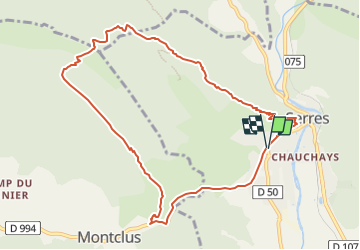
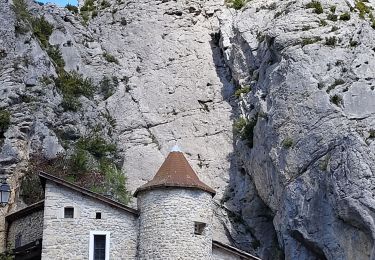
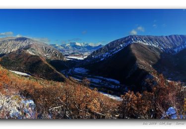
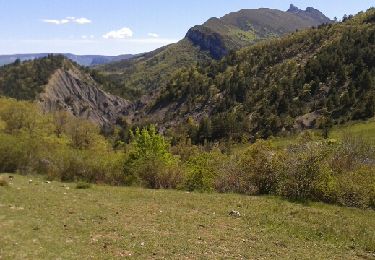
Randonnée Marche de 10,4 km à découvrir à Provence-Alpes-Côte d'Azur, Hautes-Alpes, Serres. Cette randonnée est proposée par Marco05.
Description
Jolie randonnée au départ de Serres.
Avec deux voitures, on peut éviter le passage sur le goudron à la fin de la boucle.
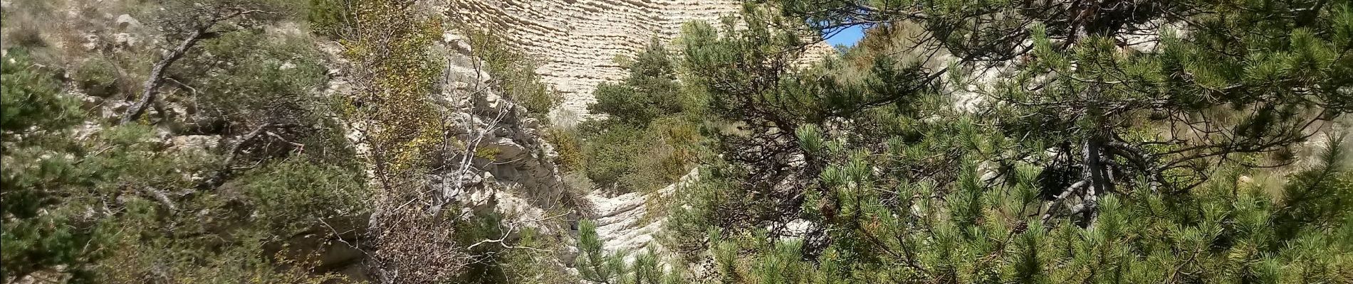
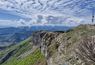
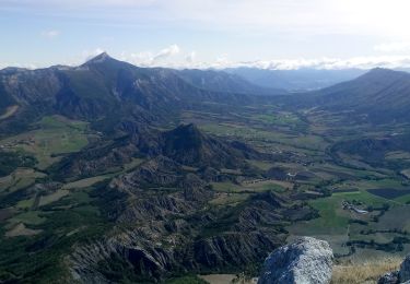
Paysage varié plus aride que le côté Ecrins du département.
Un passage un peu exposé mais pas difficulté particulière.
Localisation
Pays :
France
Région :
Provence-Alpes-Côte d'Azur
Département/Province :
Hautes-Alpes
Commune :
Serres
Localité :
Unknown
Départ:(Dec)
Départ:(UTM)
715718 ; 4922761 (31T) N.
Commentaires
Randonnées à proximité
![Randonnée Marche Serres - Tour des Baronnies du Buëch - Serres - Montmorin - Photo](https://media.geolcdn.com/t/375/260/ext.jpg?maxdim=2&url=https%3A%2F%2Fservices.sitytrail.com%2FGeolivesWS%2FDownloadMedia.ashx%3FTrailID%3D108455%26Media%3D1167_1.jpg)
![Marche Marche](https://static1.geolcdn.com/sitytour/trail-icons/101.png)
Tour des Baronnies du Buëch - Serres - Montmorin
Marche
Difficile
(1)
Serres,
Provence-Alpes-Côte d'Azur,
Hautes-Alpes,
France
![](/images/other/stat-length.png)
20 km | 33 km-effort
4h 0min
![](https://static1.geolcdn.com/siteimages/upload/files/16400158638029165_repeat_loop_refresh_sync_direction_icon.png)
Non
![Randonnée Marche Sigottier - Le Duffre - Photo](https://media.geolcdn.com/t/375/260/9fdab0d8-c7f6-4706-b667-bee3c71c8792.jpg&format=jpg&maxdim=2)
![Marche Marche](https://static1.geolcdn.com/sitytour/trail-icons/101.png)
Le Duffre
Marche
Moyen
Sigottier,
Provence-Alpes-Côte d'Azur,
Hautes-Alpes,
France
![](/images/other/stat-length.png)
10,3 km | 19,1 km-effort
4h 19min
![](https://static1.geolcdn.com/siteimages/upload/files/16400158638029165_repeat_loop_refresh_sync_direction_icon.png)
Oui
![Randonnée Marche Serres - Rocher de Beaumont - Photo](https://media.geolcdn.com/t/375/260/3fe601cb-d649-4fbf-81ae-1e708fafb3ae.jpg&format=jpg&maxdim=2)
![Marche Marche](https://static1.geolcdn.com/sitytour/trail-icons/101.png)
Rocher de Beaumont
Marche
Difficile
Serres,
Provence-Alpes-Côte d'Azur,
Hautes-Alpes,
France
![](/images/other/stat-length.png)
11,3 km | 23 km-effort
5h 19min
![](https://static1.geolcdn.com/siteimages/upload/files/16400158638029165_repeat_loop_refresh_sync_direction_icon.png)
Non
![Randonnée Marche Serres - Arambre - Photo](https://media.geolcdn.com/t/375/260/9748b9b0-2d8c-4b5c-babd-78995be35a60.jpg&format=jpg&maxdim=2)
![Marche Marche](https://static1.geolcdn.com/sitytour/trail-icons/101.png)
Arambre
Marche
Difficile
Serres,
Provence-Alpes-Côte d'Azur,
Hautes-Alpes,
France
![](/images/other/stat-length.png)
6,8 km | 16,9 km-effort
3h 50min
![](https://static1.geolcdn.com/siteimages/upload/files/16400158638029165_repeat_loop_refresh_sync_direction_icon.png)
Oui
![Randonnée Marche Serres - R32 Au dessus de Serres - Photo](https://media.geolcdn.com/t/375/260/ext.jpg?maxdim=2&url=https%3A%2F%2Fservices.sitytrail.com%2FGeolivesWS%2FDownloadMedia.ashx%3FTrailID%3D890891%26Media%3D1c14b8cd-ab82-48b6-be0c-f9e8f16eb520.jpg)
![Marche Marche](https://static1.geolcdn.com/sitytour/trail-icons/101.png)
R32 Au dessus de Serres
Marche
Moyen
Serres,
Provence-Alpes-Côte d'Azur,
Hautes-Alpes,
France
![](/images/other/stat-length.png)
5,4 km | 10,5 km-effort
2h 8min
![](https://static1.geolcdn.com/siteimages/upload/files/16400158638029165_repeat_loop_refresh_sync_direction_icon.png)
Oui
![Randonnée Marche Sigottier - Boucle des Michons Départ Sigottier 322+ - Photo](https://media.geolcdn.com/t/375/260/e958f610-dae3-4d24-8ab2-439a59518395.jpg&format=jpg&maxdim=2)
![Marche Marche](https://static1.geolcdn.com/sitytour/trail-icons/101.png)
Boucle des Michons Départ Sigottier 322+
Marche
Facile
Sigottier,
Provence-Alpes-Côte d'Azur,
Hautes-Alpes,
France
![](/images/other/stat-length.png)
8,8 km | 13,1 km-effort
3h 20min
![](https://static1.geolcdn.com/siteimages/upload/files/16400158638029165_repeat_loop_refresh_sync_direction_icon.png)
Oui
![Randonnée Marche Serres - 20191212_Serres - Les Trois Boucles - Photo](https://media.geolcdn.com/t/375/260/a07f2307-6533-4199-a042-6fa5d3f3e797.jpg&format=jpg&maxdim=2)
![Marche Marche](https://static1.geolcdn.com/sitytour/trail-icons/101.png)
20191212_Serres - Les Trois Boucles
Marche
Moyen
Serres,
Provence-Alpes-Côte d'Azur,
Hautes-Alpes,
France
![](/images/other/stat-length.png)
20 km | 34 km-effort
7h 51min
![](https://static1.geolcdn.com/siteimages/upload/files/16400158638029165_repeat_loop_refresh_sync_direction_icon.png)
Oui
![Randonnée Marche Sigottier - R35 La Montagne - Photo](https://media.geolcdn.com/t/375/260/ext.jpg?maxdim=2&url=https%3A%2F%2Fservices.sitytrail.com%2FGeolivesWS%2FDownloadMedia.ashx%3FTrailID%3D890894%26Media%3D56a91488-508f-4ceb-a3b8-bc71eb73e519.jpg)
![Marche Marche](https://static1.geolcdn.com/sitytour/trail-icons/101.png)
R35 La Montagne
Marche
Moyen
Sigottier,
Provence-Alpes-Côte d'Azur,
Hautes-Alpes,
France
![](/images/other/stat-length.png)
10,5 km | 18 km-effort
3h 40min
![](https://static1.geolcdn.com/siteimages/upload/files/16400158638029165_repeat_loop_refresh_sync_direction_icon.png)
Oui
![Randonnée Marche Serres - le chemin des Moines - Photo](https://media.geolcdn.com/t/375/260/ext.jpg?maxdim=2&url=https%3A%2F%2Fservices.sitytrail.com%2FGeolivesWS%2FDownloadMedia.ashx%3FTrailID%3D569398%26Media%3Dfix__20160428151522.jpg)
![Marche Marche](https://static1.geolcdn.com/sitytour/trail-icons/101.png)
le chemin des Moines
Marche
Très facile
Serres,
Provence-Alpes-Côte d'Azur,
Hautes-Alpes,
France
![](/images/other/stat-length.png)
6,9 km | 12 km-effort
2h 24min
![](https://static1.geolcdn.com/siteimages/upload/files/16400158638029165_repeat_loop_refresh_sync_direction_icon.png)
Oui