![](/images/other/stat-length.png)
![Randonnée Marche Saint-Michel-de-Chaillol - Pic Queyrel - Photo](https://media.geolcdn.com/t/1900/400/3587472a-93b3-4434-9291-823cc836fe6a.jpg&format=pjpeg&maxdim=2)
Pic Queyrel
Marco05
Utilisateur GUIDE
![Longueur](/images/other/stat-length.png)
![Altitude max](https://static1.geolcdn.com/siteimages/upload/files/1508320355ic_sort_altitude_max_24dp.png)
![Dénivelé positif](https://static1.geolcdn.com/siteimages/upload/files/1508320355ic_sort_den_pos_24dp.png)
![Km-Effort](/images/other/stat-length.png)
![Altitude min](https://static1.geolcdn.com/siteimages/upload/files/1508320355ic_sort_altitude_min_24dp.png)
![Dénivelé négatif](https://static1.geolcdn.com/siteimages/upload/files/1508320355ic_sort_den_neg_24dp.png)
![Boucle](https://static1.geolcdn.com/siteimages/upload/files/16400158638029165_repeat_loop_refresh_sync_direction_icon.png)
![Marche](https://static1.geolcdn.com/sitytour/trail-icons/101.png)
4h29
Difficulté : Difficile
![Scannez ce code QR pour ouvrir la randonnée dans l'application SityTrail](https://capi.geolives.com/qq0zvz2zws4bq2lad0pu/sitytour/trails/3188256/qr.png?size=200)
Application GPS de randonnée GRATUITE
À propos
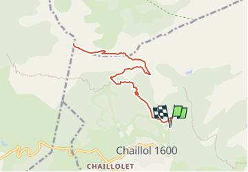
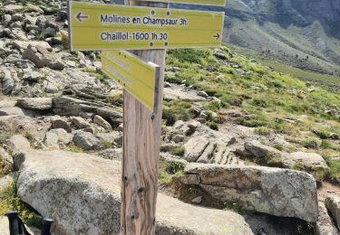
Randonnée Marche de 10,4 km à découvrir à Provence-Alpes-Côte d'Azur, Hautes-Alpes, Saint-Michel-de-Chaillol. Cette randonnée est proposée par Marco05.
Description
Départ de la station Chaillol 1600.
On peut monter la voiture à 1700m par la piste qui n'est pas en très bon état.
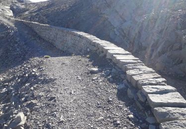
Deux passages dans lesquels on doit mettre les mains.
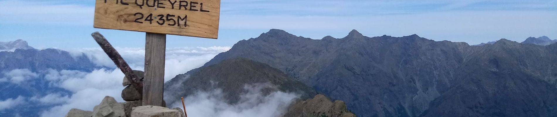
Donc, une randonnée qui demande un peu de souplesse et de ne pas avoir trops peur du vide.
Localisation
Commentaires
Randonnées à proximité
![Randonnée Marche Saint-Jean-Saint-Nicolas - Circuit de Costebelle - Photo](https://media.geolcdn.com/t/375/260/ext.jpg?maxdim=2&url=https%3A%2F%2Fservices.sitytrail.com%2FGeolivesWS%2FDownloadMedia.ashx%3FTrailID%3D269960%26Media%3Dfix__20140424150455.jpg)
![Marche Marche](https://static1.geolcdn.com/sitytour/trail-icons/101.png)
Marche
![](/images/other/stat-length.png)
![](https://static1.geolcdn.com/siteimages/upload/files/16400158638029165_repeat_loop_refresh_sync_direction_icon.png)
![Randonnée Marche Saint-Bonnet-en-Champsaur - Infournas haut - Lac des Barbeyroux - Les infournas - Photo](https://media.geolcdn.com/t/375/260/0538c280-feb5-4d65-96e8-19b0b69c47f0.jpg&format=jpg&maxdim=2)
![Marche Marche](https://static1.geolcdn.com/sitytour/trail-icons/101.png)
Marche
![](/images/other/stat-length.png)
![](https://static1.geolcdn.com/siteimages/upload/files/16400158638029165_repeat_loop_refresh_sync_direction_icon.png)
![Randonnée Marche Saint-Michel-de-Chaillol - Col de l'Escalier - Photo](https://media.geolcdn.com/t/375/260/ab16f81e-2013-445c-8eb3-48638c0edd61.jpg&format=jpg&maxdim=2)
![Marche Marche](https://static1.geolcdn.com/sitytour/trail-icons/101.png)
Marche
![](/images/other/stat-length.png)
![](https://static1.geolcdn.com/siteimages/upload/files/16400158638029165_repeat_loop_refresh_sync_direction_icon.png)
![Randonnée Marche Saint-Michel-de-Chaillol - Pic du Tourond - Photo](https://media.geolcdn.com/t/375/260/01ce6341-dc1d-4078-9a13-caf8c777653c.jpg&format=jpg&maxdim=2)
![Marche Marche](https://static1.geolcdn.com/sitytour/trail-icons/101.png)
Marche
![](/images/other/stat-length.png)
![](https://static1.geolcdn.com/siteimages/upload/files/16400158638029165_repeat_loop_refresh_sync_direction_icon.png)
![Randonnée Marche Saint-Michel-de-Chaillol - Lac de Malcros - Photo](https://media.geolcdn.com/t/375/260/6a7a1b5d-0b23-46a5-9179-bf8c821d0afb.jpg&format=jpg&maxdim=2)
![Marche Marche](https://static1.geolcdn.com/sitytour/trail-icons/101.png)
Marche
![](/images/other/stat-length.png)
![](https://static1.geolcdn.com/siteimages/upload/files/16400158638029165_repeat_loop_refresh_sync_direction_icon.png)
![Randonnée Marche Saint-Michel-de-Chaillol - pic de queyrel - Photo](https://media.geolcdn.com/t/375/260/16bf5dfe-1e8f-41f7-8280-542f457efdf9.jpg&format=jpg&maxdim=2)
![Marche Marche](https://static1.geolcdn.com/sitytour/trail-icons/101.png)
Marche
![](/images/other/stat-length.png)
![](https://static1.geolcdn.com/siteimages/upload/files/16400158638029165_repeat_loop_refresh_sync_direction_icon.png)
![Randonnée Marche Saint-Michel-de-Chaillol - Tête ouest de Mal Cros - Photo](https://media.geolcdn.com/t/375/260/8702d498-6db2-40a6-b115-ed3ce3d7c0b6.jpg&format=jpg&maxdim=2)
![Marche Marche](https://static1.geolcdn.com/sitytour/trail-icons/101.png)
Marche
![](/images/other/stat-length.png)
![](https://static1.geolcdn.com/siteimages/upload/files/16400158638029165_repeat_loop_refresh_sync_direction_icon.png)
![Randonnée Marche Saint-Jean-Saint-Nicolas - Pont Ricous Pelissier Coste Belle Pont du Fossé - Photo](https://media.geolcdn.com/t/375/260/ext.jpg?maxdim=2&url=https%3A%2F%2Fstatic1.geolcdn.com%2Fsiteimages%2Fupload%2Ffiles%2F1553511878bg_sport_marche.png)
![Marche Marche](https://static1.geolcdn.com/sitytour/trail-icons/101.png)
Marche
![](/images/other/stat-length.png)
![](https://static1.geolcdn.com/siteimages/upload/files/16400158638029165_repeat_loop_refresh_sync_direction_icon.png)
![Randonnée Marche Saint-Michel-de-Chaillol - col de la pisse - Photo](https://media.geolcdn.com/t/375/260/8e690fd3-f0ad-4120-9a92-3c8fe4646f31.jpg&format=jpg&maxdim=2)
![Marche Marche](https://static1.geolcdn.com/sitytour/trail-icons/101.png)
Marche
![](/images/other/stat-length.png)
![](https://static1.geolcdn.com/siteimages/upload/files/16400158638029165_repeat_loop_refresh_sync_direction_icon.png)