![](/images/other/stat-length.png)
![Randonnée Marche Gap - Pic de Gleize - Photo](https://media.geolcdn.com/t/1900/400/9b3dcddd-15e9-4793-a987-aa74cd6c203d.jpg&format=pjpeg&maxdim=2)
Pic de Gleize
Marco05
Utilisateur GUIDE
![Longueur](/images/other/stat-length.png)
Longueur
4,8 km
![Altitude max](https://static1.geolcdn.com/siteimages/upload/files/1508320355ic_sort_altitude_max_24dp.png)
Altitude max
2142 m
![Dénivelé positif](https://static1.geolcdn.com/siteimages/upload/files/1508320355ic_sort_den_pos_24dp.png)
Dénivelé positif
441 m
![Km-Effort](/images/other/stat-length.png)
Km-Effort
10,6 km
![Altitude min](https://static1.geolcdn.com/siteimages/upload/files/1508320355ic_sort_altitude_min_24dp.png)
Altitude min
1693 m
![Dénivelé négatif](https://static1.geolcdn.com/siteimages/upload/files/1508320355ic_sort_den_neg_24dp.png)
Dénivelé négatif
442 m
![Boucle](https://static1.geolcdn.com/siteimages/upload/files/16400158638029165_repeat_loop_refresh_sync_direction_icon.png)
Boucle
Oui
Date de création :
2022-04-01 12:02:47.102
Dernière modification :
2022-11-29 12:55:24.129
![Marche](https://static1.geolcdn.com/sitytour/trail-icons/101.png)
2h25
Difficulté : Moyen
![Scannez ce code QR pour ouvrir la randonnée dans l'application SityTrail](https://capi.geolives.com/qq0zvz2zws4bq2lad0pu/sitytour/trails/3188253/qr.png?size=200)
Application GPS de randonnée GRATUITE
À propos
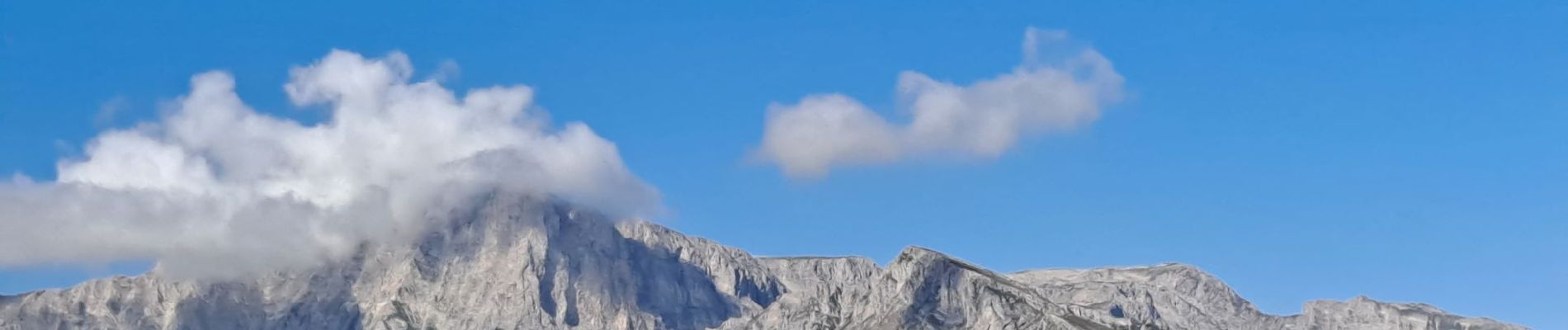
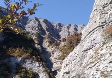
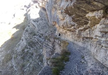
Randonnée Marche de 4,8 km à découvrir à Provence-Alpes-Côte d'Azur, Hautes-Alpes, Gap. Cette randonnée est proposée par Marco05.
Description
Départ du col de Gleize, à proximité du col Bayard au nord de Gap.
C'est une boucle de difficulté moyenne, mais qui empreint une arête facile mais exposée.
Attention aux personnes sujettes au vertige.
Localisation
Pays :
France
Région :
Provence-Alpes-Côte d'Azur
Département/Province :
Hautes-Alpes
Commune :
Gap
Localité :
Gap
Départ:(Dec)
Départ:(UTM)
265817 ; 4945249 (32T) N.
Commentaires
Randonnées à proximité
![Randonnée Marche Gap - Brèche et croix de Charance - Photo](https://media.geolcdn.com/t/375/260/ext.jpg?maxdim=2&url=https%3A%2F%2Fservices.sitytrail.com%2FGeolivesWS%2FDownloadMedia.ashx%3FTrailID%3D95802%26Media%3D20111201151419.jpg)
![Marche Marche](https://static1.geolcdn.com/sitytour/trail-icons/101.png)
Brèche et croix de Charance
Marche
Facile
(1)
Gap,
Provence-Alpes-Côte d'Azur,
Hautes-Alpes,
France
![](/images/other/stat-length.png)
8,6 km | 18,5 km-effort
2h 13min
![](https://static1.geolcdn.com/siteimages/upload/files/16400158638029165_repeat_loop_refresh_sync_direction_icon.png)
Non
![Randonnée Marche Rabou - Rabou Tour du Puy - Photo](https://media.geolcdn.com/t/375/260/805e1ce0-378d-4868-bdbb-2f6f352f7b11.jpg&format=jpg&maxdim=2)
![Marche Marche](https://static1.geolcdn.com/sitytour/trail-icons/101.png)
Rabou Tour du Puy
Marche
Moyen
Rabou,
Provence-Alpes-Côte d'Azur,
Hautes-Alpes,
France
![](/images/other/stat-length.png)
11,5 km | 21 km-effort
4h 46min
![](https://static1.geolcdn.com/siteimages/upload/files/16400158638029165_repeat_loop_refresh_sync_direction_icon.png)
Oui
![Randonnée Marche Gap - Pic de Charance - Photo](https://media.geolcdn.com/t/375/260/1b819787-5cbc-4e39-b2ee-7b1b220b0af8.jpg&format=jpg&maxdim=2)
![Marche Marche](https://static1.geolcdn.com/sitytour/trail-icons/101.png)
Pic de Charance
Marche
Moyen
Gap,
Provence-Alpes-Côte d'Azur,
Hautes-Alpes,
France
![](/images/other/stat-length.png)
8,9 km | 19 km-effort
4h 18min
![](https://static1.geolcdn.com/siteimages/upload/files/16400158638029165_repeat_loop_refresh_sync_direction_icon.png)
Oui
![Randonnée Marche Rabou - Pic Melette - Photo](https://media.geolcdn.com/t/375/260/4622a0c3-66f1-414b-9c6c-2d569eb751b3.jpg&format=jpg&maxdim=2)
![Marche Marche](https://static1.geolcdn.com/sitytour/trail-icons/101.png)
Pic Melette
Marche
Difficile
Rabou,
Provence-Alpes-Côte d'Azur,
Hautes-Alpes,
France
![](/images/other/stat-length.png)
9,8 km | 22 km-effort
4h 59min
![](https://static1.geolcdn.com/siteimages/upload/files/16400158638029165_repeat_loop_refresh_sync_direction_icon.png)
Oui
![Randonnée Marche Gap - Cuchon-Pic de Charance - Photo](https://media.geolcdn.com/t/375/260/273370c5-f091-46d0-92ed-fb2a447f25db.jpg&format=jpg&maxdim=2)
![Marche Marche](https://static1.geolcdn.com/sitytour/trail-icons/101.png)
Cuchon-Pic de Charance
Marche
Difficile
Gap,
Provence-Alpes-Côte d'Azur,
Hautes-Alpes,
France
![](/images/other/stat-length.png)
12,3 km | 24 km-effort
5h 32min
![](https://static1.geolcdn.com/siteimages/upload/files/16400158638029165_repeat_loop_refresh_sync_direction_icon.png)
Oui
![Randonnée Marche Gap - Col de Guizière - Photo](https://media.geolcdn.com/t/375/260/48c56f83-5df5-469d-a27d-85eb85489bb3.jpg&format=jpg&maxdim=2)
![Marche Marche](https://static1.geolcdn.com/sitytour/trail-icons/101.png)
Col de Guizière
Marche
Moyen
Gap,
Provence-Alpes-Côte d'Azur,
Hautes-Alpes,
France
![](/images/other/stat-length.png)
8,7 km | 17,5 km-effort
3h 58min
![](https://static1.geolcdn.com/siteimages/upload/files/16400158638029165_repeat_loop_refresh_sync_direction_icon.png)
Oui
![Randonnée A pied Rabou - R54 Le sentier des Bancs - Photo](https://media.geolcdn.com/t/375/260/6a1636b4-b223-413d-a187-700130d298fe.jpg&format=jpg&maxdim=2)
![A pied A pied](https://static1.geolcdn.com/sitytour/trail-icons/100.png)
R54 Le sentier des Bancs
A pied
Facile
Rabou,
Provence-Alpes-Côte d'Azur,
Hautes-Alpes,
France
![](/images/other/stat-length.png)
6,6 km | 10,6 km-effort
3h 56min
![](https://static1.geolcdn.com/siteimages/upload/files/16400158638029165_repeat_loop_refresh_sync_direction_icon.png)
Non
![Randonnée Marche La Fare-en-Champsaur - Le Girolet - Photo](https://media.geolcdn.com/t/375/260/db985afe-8ded-41a5-8002-487c3b42ed04.jpg&format=jpg&maxdim=2)
![Marche Marche](https://static1.geolcdn.com/sitytour/trail-icons/101.png)
Le Girolet
Marche
Moyen
La Fare-en-Champsaur,
Provence-Alpes-Côte d'Azur,
Hautes-Alpes,
France
![](/images/other/stat-length.png)
11,6 km | 24 km-effort
4h 45min
![](https://static1.geolcdn.com/siteimages/upload/files/16400158638029165_repeat_loop_refresh_sync_direction_icon.png)
Oui
![Randonnée Marche Rabou - gorge du petit Buëch - Photo](https://media.geolcdn.com/t/375/260/1a9809db-5017-423f-9623-d7352e709e2a.jpg&format=jpg&maxdim=2)
![Marche Marche](https://static1.geolcdn.com/sitytour/trail-icons/101.png)
gorge du petit Buëch
Marche
Difficile
Rabou,
Provence-Alpes-Côte d'Azur,
Hautes-Alpes,
France
![](/images/other/stat-length.png)
18,9 km | 29 km-effort
6h 23min
![](https://static1.geolcdn.com/siteimages/upload/files/16400158638029165_repeat_loop_refresh_sync_direction_icon.png)
Oui