![](/images/other/stat-length.png)
![Randonnée Marche Veynes - Col de Combe noire-Veynes - Photo](https://media.geolcdn.com/t/1900/400/ext.pjpeg?maxdim=2&url=https%3A%2F%2Fmedia.geolcdn.com%2Ff%2Fb771f9a6-d8f6-4104-bb87-2efae92c170f.jpg)
Col de Combe noire-Veynes
Marco05
Utilisateur
![Longueur](/images/other/stat-length.png)
Longueur
9,7 km
![Altitude max](https://static1.geolcdn.com/siteimages/upload/files/1508320355ic_sort_altitude_max_24dp.png)
Altitude max
1299 m
![Dénivelé positif](https://static1.geolcdn.com/siteimages/upload/files/1508320355ic_sort_den_pos_24dp.png)
Dénivelé positif
590 m
![Km-Effort](/images/other/stat-length.png)
Km-Effort
17,6 km
![Altitude min](https://static1.geolcdn.com/siteimages/upload/files/1508320355ic_sort_altitude_min_24dp.png)
Altitude min
849 m
![Dénivelé négatif](https://static1.geolcdn.com/siteimages/upload/files/1508320355ic_sort_den_neg_24dp.png)
Dénivelé négatif
593 m
![Boucle](https://static1.geolcdn.com/siteimages/upload/files/16400158638029165_repeat_loop_refresh_sync_direction_icon.png)
Boucle
Oui
Date de création :
2022-04-01 12:00:28.053
Dernière modification :
2022-09-02 15:36:49.907
![Marche](https://static1.geolcdn.com/sitytour/trail-icons/101.png)
4h00
Difficulté : Moyen
![Scannez ce code QR pour ouvrir la randonnée dans l'application SityTrail](https://capi.geolives.com/qq0zvz2zws4bq2lad0pu/sitytour/trails/3188224/qr.png?size=200)
Application GPS de randonnée GRATUITE
À propos
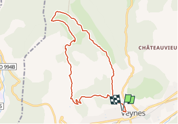
Randonnée Marche de 9,7 km à découvrir à Provence-Alpes-Côte d'Azur, Hautes-Alpes, Veynes. Cette randonnée est proposée par Marco05.
Description
Petite randonnée très sympathique au départ de la piscine de Veynes.
Le départ dans les marnes est un peu raide au début, mais ensuite la pente est très accessible.
Localisation
Pays :
France
Région :
Provence-Alpes-Côte d'Azur
Département/Province :
Hautes-Alpes
Commune :
Veynes
Localité :
Unknown
Départ:(Dec)
Départ:(UTM)
724114 ; 4935223 (31T) N.
Commentaires
Randonnées à proximité
![Randonnée V.T.T. Veynes - VTT29 - Rando famille - Photo](https://media.geolcdn.com/t/375/260/ext.jpg?maxdim=2&url=https%3A%2F%2Fservices.sitytrail.com%2FGeolivesWS%2FDownloadMedia.ashx%3FTrailID%3D894049%26Media%3D41fd01b2-a1b9-4de0-b05b-7c7f08af0a98.jpg)
![V.T.T. V.T.T.](https://static1.geolcdn.com/sitytour/trail-icons/202.png)
VTT29 - Rando famille
V.T.T.
Facile
(1)
Veynes,
Provence-Alpes-Côte d'Azur,
Hautes-Alpes,
France
![](/images/other/stat-length.png)
10,9 km | 13,6 km-effort
54min
![](https://static1.geolcdn.com/siteimages/upload/files/16400158638029165_repeat_loop_refresh_sync_direction_icon.png)
Oui
![Randonnée V.T.T. Veynes - VTT14 - Les crêtes de la Longeagne - Photo](https://media.geolcdn.com/t/375/260/ext.jpg?maxdim=2&url=https%3A%2F%2Fservices.sitytrail.com%2FGeolivesWS%2FDownloadMedia.ashx%3FTrailID%3D893997%26Media%3D7ccf264f-f2dd-40d2-9710-b4f1366285f7.jpg)
![V.T.T. V.T.T.](https://static1.geolcdn.com/sitytour/trail-icons/202.png)
VTT14 - Les crêtes de la Longeagne
V.T.T.
Très difficile
(1)
Veynes,
Provence-Alpes-Côte d'Azur,
Hautes-Alpes,
France
![](/images/other/stat-length.png)
39 km | 57 km-effort
3h 15min
![](https://static1.geolcdn.com/siteimages/upload/files/16400158638029165_repeat_loop_refresh_sync_direction_icon.png)
Oui
![Randonnée V.T.T. Veynes - VTT03 - Le défi de Veynes - Photo](https://media.geolcdn.com/t/375/260/ext.jpg?maxdim=2&url=https%3A%2F%2Fservices.sitytrail.com%2FGeolivesWS%2FDownloadMedia.ashx%3FTrailID%3D893894%26Media%3Dff964c78-0895-4177-a23a-bbf5c1f8ef2b.jpg)
![V.T.T. V.T.T.](https://static1.geolcdn.com/sitytour/trail-icons/202.png)
VTT03 - Le défi de Veynes
V.T.T.
Moyen
(2)
Veynes,
Provence-Alpes-Côte d'Azur,
Hautes-Alpes,
France
![](/images/other/stat-length.png)
23 km | 31 km-effort
1h 31min
![](https://static1.geolcdn.com/siteimages/upload/files/16400158638029165_repeat_loop_refresh_sync_direction_icon.png)
Oui
![Randonnée V.T.T. Veynes - VTT02 - Aiguebelle - Photo](https://media.geolcdn.com/t/375/260/ext.jpg?maxdim=2&url=https%3A%2F%2Fservices.sitytrail.com%2FGeolivesWS%2FDownloadMedia.ashx%3FTrailID%3D893892%26Media%3Da8e741f3-b85e-4e92-89bd-a0f44b11f95d.jpg)
![V.T.T. V.T.T.](https://static1.geolcdn.com/sitytour/trail-icons/202.png)
VTT02 - Aiguebelle
V.T.T.
Facile
(2)
Veynes,
Provence-Alpes-Côte d'Azur,
Hautes-Alpes,
France
![](/images/other/stat-length.png)
16,7 km | 21 km-effort
1h 23min
![](https://static1.geolcdn.com/siteimages/upload/files/16400158638029165_repeat_loop_refresh_sync_direction_icon.png)
Oui
![Randonnée V.T.T. Veynes - VTT01 - Les Eygaux - Photo](https://media.geolcdn.com/t/375/260/ext.jpg?maxdim=2&url=https%3A%2F%2Fservices.sitytrail.com%2FGeolivesWS%2FDownloadMedia.ashx%3FTrailID%3D893891%26Media%3Da3cfe01b-296c-449d-80b6-97a4ee7d4f1d.jpg)
![V.T.T. V.T.T.](https://static1.geolcdn.com/sitytour/trail-icons/202.png)
VTT01 - Les Eygaux
V.T.T.
Facile
(3)
Veynes,
Provence-Alpes-Côte d'Azur,
Hautes-Alpes,
France
![](/images/other/stat-length.png)
14,1 km | 19,2 km-effort
1h 13min
![](https://static1.geolcdn.com/siteimages/upload/files/16400158638029165_repeat_loop_refresh_sync_direction_icon.png)
Oui
![Randonnée Marche Veynes - R10 Le tour des Eygaux - Photo](https://media.geolcdn.com/t/375/260/ext.jpg?maxdim=2&url=https%3A%2F%2Fservices.sitytrail.com%2FGeolivesWS%2FDownloadMedia.ashx%3FTrailID%3D890865%26Media%3D045a0fa6-2484-4383-b3d3-624322b8ead1.jpg)
![Marche Marche](https://static1.geolcdn.com/sitytour/trail-icons/101.png)
R10 Le tour des Eygaux
Marche
Très facile
(4)
Veynes,
Provence-Alpes-Côte d'Azur,
Hautes-Alpes,
France
![](/images/other/stat-length.png)
7,8 km | 11,3 km-effort
2h 24min
![](https://static1.geolcdn.com/siteimages/upload/files/16400158638029165_repeat_loop_refresh_sync_direction_icon.png)
Oui
![Randonnée Marche Veynes - R09 Le tour de Veynes - Photo](https://media.geolcdn.com/t/375/260/ext.jpg?maxdim=2&url=https%3A%2F%2Fservices.sitytrail.com%2FGeolivesWS%2FDownloadMedia.ashx%3FTrailID%3D890863%26Media%3Ddcd71a68-090d-41eb-95df-d7f5c76863f4.jpg)
![Marche Marche](https://static1.geolcdn.com/sitytour/trail-icons/101.png)
R09 Le tour de Veynes
Marche
Très facile
(3)
Veynes,
Provence-Alpes-Côte d'Azur,
Hautes-Alpes,
France
![](/images/other/stat-length.png)
9,5 km | 12,3 km-effort
2h 40min
![](https://static1.geolcdn.com/siteimages/upload/files/16400158638029165_repeat_loop_refresh_sync_direction_icon.png)
Oui
![Randonnée Marche Veynes - R06 glaise - Photo](https://media.geolcdn.com/t/375/260/ext.jpg?maxdim=2&url=https%3A%2F%2Fservices.sitytrail.com%2FGeolivesWS%2FDownloadMedia.ashx%3FTrailID%3D890857%26Media%3D2a45252a-ca22-4b16-aa40-6da618d5732f.jpg)
![Marche Marche](https://static1.geolcdn.com/sitytour/trail-icons/101.png)
R06 glaise
Marche
Facile
(1)
Veynes,
Provence-Alpes-Côte d'Azur,
Hautes-Alpes,
France
![](/images/other/stat-length.png)
9,1 km | 14,9 km-effort
3h 4min
![](https://static1.geolcdn.com/siteimages/upload/files/16400158638029165_repeat_loop_refresh_sync_direction_icon.png)
Oui
![Randonnée Marche Veynes - R51 Le col de Cuberselle - Photo](https://media.geolcdn.com/t/375/260/ext.jpg?maxdim=2&url=https%3A%2F%2Fservices.sitytrail.com%2FGeolivesWS%2FDownloadMedia.ashx%3FTrailID%3D890856%26Media%3D09e22e66-6969-4dad-8e24-d5d048fec167.jpg)
![Marche Marche](https://static1.geolcdn.com/sitytour/trail-icons/101.png)
R51 Le col de Cuberselle
Marche
Moyen
(3)
Veynes,
Provence-Alpes-Côte d'Azur,
Hautes-Alpes,
France
![](/images/other/stat-length.png)
10,8 km | 17,2 km-effort
3h 31min
![](https://static1.geolcdn.com/siteimages/upload/files/16400158638029165_repeat_loop_refresh_sync_direction_icon.png)
Oui