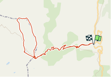
![](/images/other/stat-length.png)
Le Cimet
Marco05
Utilisateur GUIDE
![Longueur](/images/other/stat-length.png)
![Altitude max](https://static1.geolcdn.com/siteimages/upload/files/1508320355ic_sort_altitude_max_24dp.png)
![Dénivelé positif](https://static1.geolcdn.com/siteimages/upload/files/1508320355ic_sort_den_pos_24dp.png)
![Km-Effort](/images/other/stat-length.png)
![Altitude min](https://static1.geolcdn.com/siteimages/upload/files/1508320355ic_sort_altitude_min_24dp.png)
![Dénivelé négatif](https://static1.geolcdn.com/siteimages/upload/files/1508320355ic_sort_den_neg_24dp.png)
![Boucle](https://static1.geolcdn.com/siteimages/upload/files/16400158638029165_repeat_loop_refresh_sync_direction_icon.png)
![Marche](https://static1.geolcdn.com/sitytour/trail-icons/101.png)
6h10
Difficulté : Difficile
![Scannez ce code QR pour ouvrir la randonnée dans l'application SityTrail](https://capi.geolives.com/qq0zvz2zws4bq2lad0pu/sitytour/trails/3188223/qr.png?size=200)
Application GPS de randonnée GRATUITE
À propos
Randonnée Marche de 13,6 km à découvrir à Provence-Alpes-Côte d'Azur, Alpes-de-Haute-Provence, Uvernet-Fours. Cette randonnée est proposée par Marco05.
Description
A Uvernet Four prendre la direction du col de la Cayolle.
Rouler jusqu'au pont de la cascade, que l'on dépasse de 500m environ pour stationner à droite.
Suivre le vallon bien marqué en direction de "Petit col de talon".
De ce col on suit vers la droite le chemin bien marqué qui passe par la crête pour atteindre le sommet.
La descente se fait par la gauche, pour passer devant la croix du Paris-Saïgon, qui est tombé ici en 1953.
On rejoint le petit col en passant par le lac du Cimet.
C'est un 3000 vraiment pas très compliqué.
Localisation
Commentaires
Randonnées à proximité
![Randonnée Marche Uvernet-Fours - UVERNET. Bayasse, tour de la pierre éclatée o - Photo](https://media.geolcdn.com/t/375/260/585a8992-95bd-4974-8e25-bbc57e644b01.jpg&format=jpg&maxdim=2)
![Marche Marche](https://static1.geolcdn.com/sitytour/trail-icons/101.png)
Marche
![](/images/other/stat-length.png)
![](https://static1.geolcdn.com/siteimages/upload/files/16400158638029165_repeat_loop_refresh_sync_direction_icon.png)
![Randonnée Marche Uvernet-Fours - Mercantour Le Cimet 3020 m - Photo](https://media.geolcdn.com/t/375/260/ext.jpg?maxdim=2&url=https%3A%2F%2Fservices.sitytrail.com%2FGeolivesWS%2FDownloadMedia.ashx%3FTrailID%3D224622%26Media%3D20130930134741.jpg)
![Marche Marche](https://static1.geolcdn.com/sitytour/trail-icons/101.png)
Marche
![](/images/other/stat-length.png)
![](https://static1.geolcdn.com/siteimages/upload/files/16400158638029165_repeat_loop_refresh_sync_direction_icon.png)
![Marche Marche](https://static1.geolcdn.com/sitytour/trail-icons/101.png)
Marche
![](/images/other/stat-length.png)
![](https://static1.geolcdn.com/siteimages/upload/files/16400158638029165_repeat_loop_refresh_sync_direction_icon.png)
![Randonnée Marche Uvernet-Fours - Autour de la Pierre Eclatée - Photo](https://media.geolcdn.com/t/375/260/ext.jpg?maxdim=2&url=https%3A%2F%2Fservices.sitytrail.com%2FGeolivesWS%2FDownloadMedia.ashx%3FTrailID%3D101188%26Media%3D675_1.jpg)
![Marche Marche](https://static1.geolcdn.com/sitytour/trail-icons/101.png)
Marche
![](/images/other/stat-length.png)
![](https://static1.geolcdn.com/siteimages/upload/files/16400158638029165_repeat_loop_refresh_sync_direction_icon.png)
![Randonnée Marche Allos - ALLOS. LAC D ALLOS. COL DE LACAYOLE .O - Photo](https://media.geolcdn.com/t/375/260/dff6c4e7-81d7-4f55-8309-f016e1c29cdc.jpg&format=jpg&maxdim=2)
![Marche Marche](https://static1.geolcdn.com/sitytour/trail-icons/101.png)
Marche
![](/images/other/stat-length.png)
![](https://static1.geolcdn.com/siteimages/upload/files/16400158638029165_repeat_loop_refresh_sync_direction_icon.png)
![Randonnée A pied Entraunes - Circuit des Lacs - Photo](https://media.geolcdn.com/t/375/260/a896acce-5a5d-4d38-a76c-8521eb37107d.jpeg&format=jpg&maxdim=2)
![A pied A pied](https://static1.geolcdn.com/sitytour/trail-icons/100.png)
A pied
![](/images/other/stat-length.png)
![](https://static1.geolcdn.com/siteimages/upload/files/16400158638029165_repeat_loop_refresh_sync_direction_icon.png)
![Randonnée A pied Entraunes - Col de la Boucharde - Photo](https://media.geolcdn.com/t/375/260/3f8fb4f1-6b5f-4291-a48f-766ff65dc022.jpeg&format=jpg&maxdim=2)
![A pied A pied](https://static1.geolcdn.com/sitytour/trail-icons/100.png)
A pied
![](/images/other/stat-length.png)
![](https://static1.geolcdn.com/siteimages/upload/files/16400158638029165_repeat_loop_refresh_sync_direction_icon.png)
![Randonnée A pied Entraunes - Tête de la Boulière - Photo](https://media.geolcdn.com/t/375/260/4b7ce69a-b9c1-4af6-a119-2b6bf9e9add8.jpeg&format=jpg&maxdim=2)
![A pied A pied](https://static1.geolcdn.com/sitytour/trail-icons/100.png)
A pied
![](/images/other/stat-length.png)
![](https://static1.geolcdn.com/siteimages/upload/files/16400158638029165_repeat_loop_refresh_sync_direction_icon.png)
![Randonnée A pied Uvernet-Fours - Pointe de Colombart - Photo](https://media.geolcdn.com/t/375/260/5fc579df-5419-4dca-9bed-ffaaf89250e9.jpeg&format=jpg&maxdim=2)
![A pied A pied](https://static1.geolcdn.com/sitytour/trail-icons/100.png)
A pied
![](/images/other/stat-length.png)
![](https://static1.geolcdn.com/siteimages/upload/files/16400158638029165_repeat_loop_refresh_sync_direction_icon.png)