![](/images/other/stat-length.png)
![Randonnée V.T.T. Saint-Cyr-sur-Loire - Le Dolmen de Mettray - Buisson Boué - Photo](https://media.geolcdn.com/t/1900/400/ext.pjpeg?maxdim=2&url=https%3A%2F%2Fservices.sitytrail.com%2FGeolivesWS%2FDownloadMedia.ashx%3FTrailID%3D317968%26Media%3D17414_1.jpg)
Le Dolmen de Mettray - Buisson Boué
tracegps
Utilisateur
![Longueur](/images/other/stat-length.png)
![Altitude max](https://static1.geolcdn.com/siteimages/upload/files/1508320355ic_sort_altitude_max_24dp.png)
![Dénivelé positif](https://static1.geolcdn.com/siteimages/upload/files/1508320355ic_sort_den_pos_24dp.png)
![Km-Effort](/images/other/stat-length.png)
![Altitude min](https://static1.geolcdn.com/siteimages/upload/files/1508320355ic_sort_altitude_min_24dp.png)
![Dénivelé négatif](https://static1.geolcdn.com/siteimages/upload/files/1508320355ic_sort_den_neg_24dp.png)
![Boucle](https://static1.geolcdn.com/siteimages/upload/files/16400158638029165_repeat_loop_refresh_sync_direction_icon.png)
![V.T.T.](https://static1.geolcdn.com/sitytour/trail-icons/202.png)
2h00
Difficulté : Moyen
![Scannez ce code QR pour ouvrir la randonnée dans l'application SityTrail](https://capi.geolives.com/qq0zvz2zws4bq2lad0pu/sitytour/trails/317968/qr.png?size=200)
Application GPS de randonnée GRATUITE
À propos
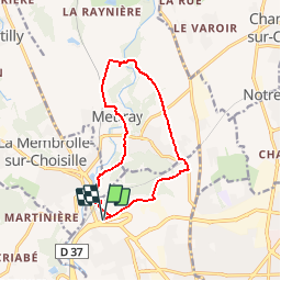
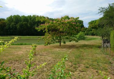
Randonnée V.T.T. de 11,6 km à découvrir à Centre-Val de Loire, Indre-et-Loire, Saint-Cyr-sur-Loire. Cette randonnée est proposée par tracegps.
Description
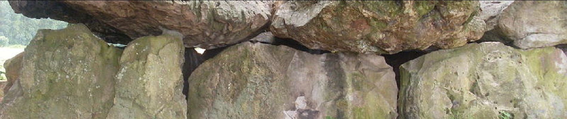
Le Dolmen de la Grotte aux Fées ou Dolmen de Mettray se situe au lieu-dit Moulin de Rechausse, à Saint-Antoine-du-Rocher. Il est classé monument historique par journal officiel du 18 avril 1914 ; le site de la Grotte aux Fées a été inscrit par arrêté en 19431. Il est propriété de la commune de Saint-Antoine-du-Rocher. Construit il y a 4000 ans, il mesure près de 11 mètres et les douze pierres qui le composent pèsent environ 88 tonnes. Trois créatures féminines auraient bâti l'édifice en une nuit ; si l'on s'avisait de déplacer les pierres, celles-ci reprendraient leur place en une nuit. Une autre tradition veut que les fées aient élu domicile à l'intérieur du dolmen.
Localisation
Commentaires
Randonnées à proximité
![Randonnée Marche Fondettes - Fondettes Vallières - Luynes Le Vieux-Bourg - 26.1km 360m 5h30 (45mn) - 2024 12 11 - Photo](https://media.geolcdn.com/t/375/260/7ea9ad8d-3a09-4814-97d4-258e1355629e.jpg&format=jpg&maxdim=2)
![Marche Marche](https://static1.geolcdn.com/sitytour/trail-icons/101.png)
Marche
![](/images/other/stat-length.png)
![](https://static1.geolcdn.com/siteimages/upload/files/16400158638029165_repeat_loop_refresh_sync_direction_icon.png)
![Randonnée Marche Fondettes - Fondettes Gare - Saint-Cyr-sur-Loire Tours - 23.4km 345m 5h10 (40mn) - 2024 10 27 - Photo](https://media.geolcdn.com/t/375/260/8177205d-60d4-4a9b-baf6-cca40bb2f1c5.jpg&format=jpg&maxdim=2)
![Marche Marche](https://static1.geolcdn.com/sitytour/trail-icons/101.png)
Marche
![](/images/other/stat-length.png)
![](https://static1.geolcdn.com/siteimages/upload/files/16400158638029165_repeat_loop_refresh_sync_direction_icon.png)
![Randonnée Marche Saint-Cyr-sur-Loire - Saint-Cyr-sur-Loire la Gagnerie - la Membrolle-sur-Choisille Mettray - 24km 405m 5h15 (50mn) - 2024 10 20 - Photo](https://media.geolcdn.com/t/375/260/21cd2b46-14f0-4eaa-a3c8-0e5f8e58cc4a.jpg&format=jpg&maxdim=2)
![Marche Marche](https://static1.geolcdn.com/sitytour/trail-icons/101.png)
Marche
![](/images/other/stat-length.png)
![](https://static1.geolcdn.com/siteimages/upload/files/16400158638029165_repeat_loop_refresh_sync_direction_icon.png)
![Randonnée Marche Fondettes - Fondettes Charcenay - Sentier Val de Choisille avec variantes - 23.5km 335m 5h10 (55mn) - 2024 10 13 - Photo](https://media.geolcdn.com/t/375/260/da5cdfb1-5871-4878-b704-e11c5bcbf000.jpg&format=jpg&maxdim=2)
![Marche Marche](https://static1.geolcdn.com/sitytour/trail-icons/101.png)
Marche
![](/images/other/stat-length.png)
![](https://static1.geolcdn.com/siteimages/upload/files/16400158638029165_repeat_loop_refresh_sync_direction_icon.png)
![Randonnée Marche Saint-Pierre-des-Corps - Saint-Pierre-des-Corps - PR Sentier du bord de Loire avec variantes - 13.6km 75m 2h55 (30mn) - 2023 10 22 - Photo](https://media.geolcdn.com/t/375/260/6a165834-3cba-4860-930a-9c6f29b052c7.jpg&format=jpg&maxdim=2)
![Marche Marche](https://static1.geolcdn.com/sitytour/trail-icons/101.png)
Marche
![](/images/other/stat-length.png)
![](https://static1.geolcdn.com/siteimages/upload/files/16400158638029165_repeat_loop_refresh_sync_direction_icon.png)
![Randonnée Marche Tours - Tours - Bd Béranger La Riche - 8.8km 45m 2h00 - 2022 09 12 - Photo](https://media.geolcdn.com/t/375/260/42e96b35-6e0b-4b51-82b8-ef6cff621515.jpg&format=jpg&maxdim=2)
![Marche Marche](https://static1.geolcdn.com/sitytour/trail-icons/101.png)
Marche
![](/images/other/stat-length.png)
![](https://static1.geolcdn.com/siteimages/upload/files/16400158638029165_repeat_loop_refresh_sync_direction_icon.png)
![Randonnée Marche Fondettes - Fondettes - Impro 4 communes - 21.6km 200m 4h40 (30mn) - 2021 04 24 - Photo](https://media.geolcdn.com/t/375/260/8360f715-226c-4f82-afa7-992b48458f8c.jpg&format=jpg&maxdim=2)
![Marche Marche](https://static1.geolcdn.com/sitytour/trail-icons/101.png)
Marche
![](/images/other/stat-length.png)
![](https://static1.geolcdn.com/siteimages/upload/files/16400158638029165_repeat_loop_refresh_sync_direction_icon.png)
![Randonnée Marche Charentilly - Charentilly - Circuit 2 avec variante - 14.8km 135m 3h05 - 2020 08 15 - Photo](https://media.geolcdn.com/t/375/260/3d2c51a1-3af7-44d8-bc0c-6a33566d6f6e.jpg&format=jpg&maxdim=2)
![Marche Marche](https://static1.geolcdn.com/sitytour/trail-icons/101.png)
Marche
![](/images/other/stat-length.png)
![](https://static1.geolcdn.com/siteimages/upload/files/16400158638029165_repeat_loop_refresh_sync_direction_icon.png)
![Randonnée Marche Mettray - Mettray - Dolmen - 12.9km 160m 2h40 - 2020 07 26 - Photo](https://media.geolcdn.com/t/375/260/7eb82ac0-48df-4237-a483-c208fe4e7abd.jpg&format=jpg&maxdim=2)
![Marche Marche](https://static1.geolcdn.com/sitytour/trail-icons/101.png)
Marche
![](/images/other/stat-length.png)
![](https://static1.geolcdn.com/siteimages/upload/files/16400158638029165_repeat_loop_refresh_sync_direction_icon.png)
beaucoup de goudron pour du Vtt