![](/images/other/stat-length.png)
![Randonnée Marche La Penne-sur-l'Ouvèze - Arrête du mont Bluye - Pierrelongue - Photo](https://media.geolcdn.com/t/1900/400/ext.pjpeg?maxdim=2&url=https%3A%2F%2Fservices.sitytrail.com%2FGeolivesWS%2FDownloadMedia.ashx%3FTrailID%3D317895%26Media%3D17305_6.jpg)
Arrête du mont Bluye - Pierrelongue
tracegps
Utilisateur
![Longueur](/images/other/stat-length.png)
![Altitude max](https://static1.geolcdn.com/siteimages/upload/files/1508320355ic_sort_altitude_max_24dp.png)
![Dénivelé positif](https://static1.geolcdn.com/siteimages/upload/files/1508320355ic_sort_den_pos_24dp.png)
![Km-Effort](/images/other/stat-length.png)
![Altitude min](https://static1.geolcdn.com/siteimages/upload/files/1508320355ic_sort_altitude_min_24dp.png)
![Dénivelé négatif](https://static1.geolcdn.com/siteimages/upload/files/1508320355ic_sort_den_neg_24dp.png)
![Boucle](https://static1.geolcdn.com/siteimages/upload/files/16400158638029165_repeat_loop_refresh_sync_direction_icon.png)
![Marche](https://static1.geolcdn.com/sitytour/trail-icons/101.png)
4h30
Difficulté : Difficile
![Scannez ce code QR pour ouvrir la randonnée dans l'application SityTrail](https://capi.geolives.com/qq0zvz2zws4bq2lad0pu/sitytour/trails/317895/qr.png?size=200)
Application GPS de randonnée GRATUITE
À propos
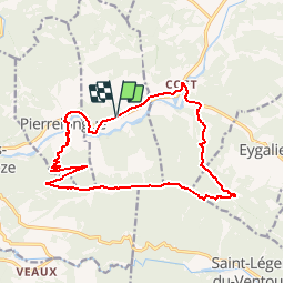
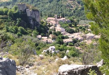
Randonnée Marche de 17,3 km à découvrir à Auvergne-Rhône-Alpes, Drôme, La Penne-sur-l'Ouvèze. Cette randonnée est proposée par tracegps.
Description
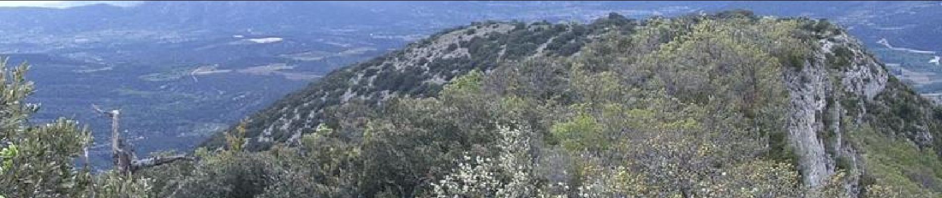
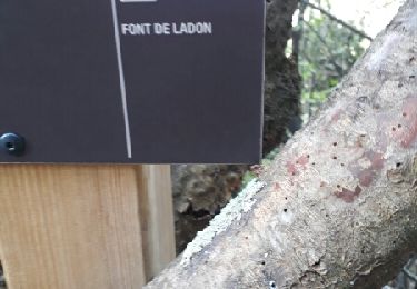
Démarrer à Pierrelongue au carrefour des Pennes sur Ouvèze. Le chemin comporte divers balisages dont il ne faut pas trop s'occuper. Passer l'Ouvèze et monter par un chemin large puis étroit vers le sommet du Bluye. Suivre la longue et magnifique crête et, au Col des Pommiers, trouver un petit sentier balisé en jaune (balisage discret et - effacé) qui descend. On débouche sur un chemin plus large à prendre à gauche jusqu'au grillage du parc animalier (lieu dit "Fond de Vège"): le suivre grosso modo en descente sur environ 200 m jusqu'à retrouver un chemin correct qui vous amènera au moulin de Cost où il faudra retirer les chaussures pour passer à gué le ruisseau. Suivre la route D72 jusqu'au pont de Cost. Pour le retour, il y a une ancienne route abandonnée - parallèle qui évite de longer le bord de la D5.
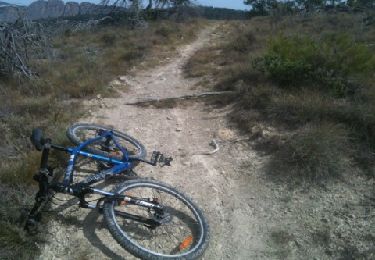
Localisation
Commentaires
Randonnées à proximité
![Randonnée V.T.T. Buis-les-Baronnies - La grande classique remise en forme - Photo](https://media.geolcdn.com/t/375/260/ext.jpg?maxdim=2&url=https%3A%2F%2Fservices.sitytrail.com%2FGeolivesWS%2FDownloadMedia.ashx%3FTrailID%3D145768%26Media%3D20120812113321.jpg)
![V.T.T. V.T.T.](https://static1.geolcdn.com/sitytour/trail-icons/202.png)
V.T.T.
![](/images/other/stat-length.png)
![](https://static1.geolcdn.com/siteimages/upload/files/16400158638029165_repeat_loop_refresh_sync_direction_icon.png)
![Randonnée Marche Buis-les-Baronnies - tour du saint Julien - Photo](https://media.geolcdn.com/t/375/260/ext.jpg?maxdim=2&url=https%3A%2F%2Fservices.sitytrail.com%2FGeolivesWS%2FDownloadMedia.ashx%3FTrailID%3D830183%26Media%3Dfix__20170916164222.jpg)
![Marche Marche](https://static1.geolcdn.com/sitytour/trail-icons/101.png)
Marche
![](/images/other/stat-length.png)
![](https://static1.geolcdn.com/siteimages/upload/files/16400158638029165_repeat_loop_refresh_sync_direction_icon.png)
![Randonnée Marche Buis-les-Baronnies - 26 roche sur buis - Photo](https://media.geolcdn.com/t/375/260/268593c3-1731-4ee7-af74-dba9efec0faa.jpg&format=jpg&maxdim=2)
![Marche Marche](https://static1.geolcdn.com/sitytour/trail-icons/101.png)
Marche
![](/images/other/stat-length.png)
![](https://static1.geolcdn.com/siteimages/upload/files/16400158638029165_repeat_loop_refresh_sync_direction_icon.png)
![Randonnée A pied Mollans-sur-Ouvèze - Roubion - Photo](https://media.geolcdn.com/t/375/260/acc73179-5e12-4051-b44f-b0980aab9979.jpeg&format=jpg&maxdim=2)
![A pied A pied](https://static1.geolcdn.com/sitytour/trail-icons/100.png)
A pied
![](/images/other/stat-length.png)
![](https://static1.geolcdn.com/siteimages/upload/files/16400158638029165_repeat_loop_refresh_sync_direction_icon.png)
![Randonnée A pied Mollans-sur-Ouvèze - Pisserouille - Photo](https://media.geolcdn.com/t/375/260/acc73179-5e12-4051-b44f-b0980aab9979.jpeg&format=jpg&maxdim=2)
![A pied A pied](https://static1.geolcdn.com/sitytour/trail-icons/100.png)
A pied
![](/images/other/stat-length.png)
![](https://static1.geolcdn.com/siteimages/upload/files/16400158638029165_repeat_loop_refresh_sync_direction_icon.png)
![Randonnée A pied Mollans-sur-Ouvèze - Crête et Ubac de Bluye - Photo](https://media.geolcdn.com/t/375/260/1f6fc386-d1d3-46f5-84c8-16749c58c4c0.jpeg&format=jpg&maxdim=2)
![A pied A pied](https://static1.geolcdn.com/sitytour/trail-icons/100.png)
A pied
![](/images/other/stat-length.png)
![](https://static1.geolcdn.com/siteimages/upload/files/16400158638029165_repeat_loop_refresh_sync_direction_icon.png)
![Randonnée A pied Mollans-sur-Ouvèze - Adret de Bluye - Photo](https://media.geolcdn.com/t/375/260/1f6fc386-d1d3-46f5-84c8-16749c58c4c0.jpeg&format=jpg&maxdim=2)
![A pied A pied](https://static1.geolcdn.com/sitytour/trail-icons/100.png)
A pied
![](/images/other/stat-length.png)
![](https://static1.geolcdn.com/siteimages/upload/files/16400158638029165_repeat_loop_refresh_sync_direction_icon.png)
![Randonnée A pied Mollans-sur-Ouvèze - Mollans - Pierrelongue - Photo](https://media.geolcdn.com/t/375/260/acc73179-5e12-4051-b44f-b0980aab9979.jpeg&format=jpg&maxdim=2)
![A pied A pied](https://static1.geolcdn.com/sitytour/trail-icons/100.png)
A pied
![](/images/other/stat-length.png)
![](https://static1.geolcdn.com/siteimages/upload/files/16400158638029165_repeat_loop_refresh_sync_direction_icon.png)
![Randonnée Marche Buis-les-Baronnies - Buis les - Baronnies Milmandre 16km. - Photo](https://media.geolcdn.com/t/375/260/ext.jpg?maxdim=2&url=https%3A%2F%2Fstatic1.geolcdn.com%2Fsiteimages%2Fupload%2Ffiles%2F1553511878bg_sport_marche.png)
![Marche Marche](https://static1.geolcdn.com/sitytour/trail-icons/101.png)
Marche
![](/images/other/stat-length.png)
![](https://static1.geolcdn.com/siteimages/upload/files/16400158638029165_repeat_loop_refresh_sync_direction_icon.png)