![](/images/other/stat-length.png)
![Randonnée V.T.T. Valloire-sur-Cisse - Vignoble et Cisse - Chouzy sur Cisse - Photo](https://media.geolcdn.com/t/1900/400/ext.pjpeg?maxdim=2&url=https%3A%2F%2Fservices.sitytrail.com%2FGeolivesWS%2FDownloadMedia.ashx%3FTrailID%3D317889%26Media%3D17292_6.jpg)
Vignoble et Cisse - Chouzy sur Cisse
tracegps
Utilisateur
![Longueur](/images/other/stat-length.png)
Longueur
18,8 km
![Altitude max](https://static1.geolcdn.com/siteimages/upload/files/1508320355ic_sort_altitude_max_24dp.png)
Altitude max
100 m
![Dénivelé positif](https://static1.geolcdn.com/siteimages/upload/files/1508320355ic_sort_den_pos_24dp.png)
Dénivelé positif
134 m
![Km-Effort](/images/other/stat-length.png)
Km-Effort
21 km
![Altitude min](https://static1.geolcdn.com/siteimages/upload/files/1508320355ic_sort_altitude_min_24dp.png)
Altitude min
59 m
![Dénivelé négatif](https://static1.geolcdn.com/siteimages/upload/files/1508320355ic_sort_den_neg_24dp.png)
Dénivelé négatif
133 m
![Boucle](https://static1.geolcdn.com/siteimages/upload/files/16400158638029165_repeat_loop_refresh_sync_direction_icon.png)
Boucle
Oui
Date de création :
2014-12-10 00:00:00.0
Dernière modification :
2014-12-10 00:00:00.0
![V.T.T.](https://static1.geolcdn.com/sitytour/trail-icons/202.png)
1h30
Difficulté : Moyen
![Scannez ce code QR pour ouvrir la randonnée dans l'application SityTrail](https://capi.geolives.com/qq0zvz2zws4bq2lad0pu/sitytour/trails/317889/qr.png?size=200)
Application GPS de randonnée GRATUITE
À propos
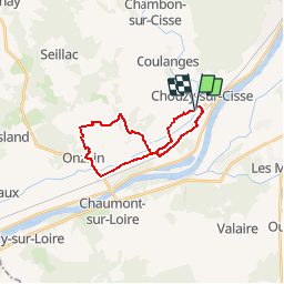
Randonnée V.T.T. de 18,8 km à découvrir à Centre-Val de Loire, Loir-et-Cher, Valloire-sur-Cisse. Cette randonnée est proposée par tracegps.
Description
Départ du parking en face de l'étang de Chouzy-sur-cisse, sortie bourg, direction Onzain. Seule difficulté 500 mètres avant l'arrivée: forte pente assez glissante au retour vers l'étang. Crédit photos : aerocom montgolfière.
Localisation
Pays :
France
Région :
Centre-Val de Loire
Département/Province :
Loir-et-Cher
Commune :
Valloire-sur-Cisse
Localité :
Unknown
Départ:(Dec)
Départ:(UTM)
367663 ; 5264517 (31T) N.
Commentaires
Randonnées à proximité
![Randonnée Marche Candé-sur-Beuvron - BBR 2024-07-30 Candé-sur-Beuvron Valaire Boucle 15 Km - Photo](https://media.geolcdn.com/t/375/260/ext.jpg?maxdim=2&url=https%3A%2F%2Fstatic1.geolcdn.com%2Fsiteimages%2Fupload%2Ffiles%2F1553511878bg_sport_marche.png)
![Marche Marche](https://static1.geolcdn.com/sitytour/trail-icons/101.png)
BBR 2024-07-30 Candé-sur-Beuvron Valaire Boucle 15 Km
Marche
Moyen
(1)
Candé-sur-Beuvron,
Centre-Val de Loire,
Loir-et-Cher,
France
![](/images/other/stat-length.png)
15,2 km | 17,2 km-effort
3h 54min
![](https://static1.geolcdn.com/siteimages/upload/files/16400158638029165_repeat_loop_refresh_sync_direction_icon.png)
Oui
![Randonnée A pied Valencisse - Chambon-Molineuf par Champigny - Photo](https://media.geolcdn.com/t/375/260/ext.jpg?maxdim=2&url=https%3A%2F%2Fstatic1.geolcdn.com%2Fsiteimages%2Fupload%2Ffiles%2F1545311037marcheuse_200dpi.jpg)
![A pied A pied](https://static1.geolcdn.com/sitytour/trail-icons/100.png)
Chambon-Molineuf par Champigny
A pied
Facile
(1)
Valencisse,
Centre-Val de Loire,
Loir-et-Cher,
France
![](/images/other/stat-length.png)
14,7 km | 18,1 km-effort
Inconnu
![](https://static1.geolcdn.com/siteimages/upload/files/16400158638029165_repeat_loop_refresh_sync_direction_icon.png)
Oui
![Randonnée Cyclotourisme Candé-sur-Beuvron - E Candé sur Beuvron à Montlouis sur Loire - Photo](https://media.geolcdn.com/t/375/260/7739fb38-bd79-4cd9-a9de-f14cf05cda61.jpg&format=jpg&maxdim=2)
![Cyclotourisme Cyclotourisme](https://static1.geolcdn.com/sitytour/trail-icons/204.png)
E Candé sur Beuvron à Montlouis sur Loire
Cyclotourisme
Facile
Candé-sur-Beuvron,
Centre-Val de Loire,
Loir-et-Cher,
France
![](/images/other/stat-length.png)
47 km | 52 km-effort
3h 26min
![](https://static1.geolcdn.com/siteimages/upload/files/16400158638029165_repeat_loop_refresh_sync_direction_icon.png)
Non
![Randonnée Marche Valloire-sur-Cisse - Randonnée BBR du 18 novembre 2020 - Photo](https://media.geolcdn.com/t/375/260/d5721fd4-941b-4b90-8a20-e6d5dc2dbd16.jpg&format=jpg&maxdim=2)
![Marche Marche](https://static1.geolcdn.com/sitytour/trail-icons/101.png)
Randonnée BBR du 18 novembre 2020
Marche
Très facile
Valloire-sur-Cisse,
Centre-Val de Loire,
Loir-et-Cher,
France
![](/images/other/stat-length.png)
13,8 km | 15,5 km-effort
2h 50min
![](https://static1.geolcdn.com/siteimages/upload/files/16400158638029165_repeat_loop_refresh_sync_direction_icon.png)
Oui
![Randonnée Marche Candé-sur-Beuvron - Randonnée au départ de Candé sur Beuvron - Photo](https://media.geolcdn.com/t/375/260/803498ae-6137-45b5-a7c7-0a5f4cb64aa4.jpg&format=jpg&maxdim=2)
![Marche Marche](https://static1.geolcdn.com/sitytour/trail-icons/101.png)
Randonnée au départ de Candé sur Beuvron
Marche
Moyen
Candé-sur-Beuvron,
Centre-Val de Loire,
Loir-et-Cher,
France
![](/images/other/stat-length.png)
26 km | 29 km-effort
6h 3min
![](https://static1.geolcdn.com/siteimages/upload/files/16400158638029165_repeat_loop_refresh_sync_direction_icon.png)
Oui
![Randonnée Marche Candé-sur-Beuvron - reconnaissance BBR aux Allees - Photo](https://media.geolcdn.com/t/375/260/0424072e-c9e6-435c-9043-15ae534dbd30.jpg&format=jpg&maxdim=2)
![Marche Marche](https://static1.geolcdn.com/sitytour/trail-icons/101.png)
reconnaissance BBR aux Allees
Marche
Très facile
Candé-sur-Beuvron,
Centre-Val de Loire,
Loir-et-Cher,
France
![](/images/other/stat-length.png)
45 km | 52 km-effort
6h 27min
![](https://static1.geolcdn.com/siteimages/upload/files/16400158638029165_repeat_loop_refresh_sync_direction_icon.png)
Non
![Randonnée Marche Valloire-sur-Cisse - BBR 2025-01-29 Coulanges - Chouzy-sur-Cisse 15 km - Photo](https://media.geolcdn.com/t/375/260/ext.jpg?maxdim=2&url=https%3A%2F%2Fstatic1.geolcdn.com%2Fsiteimages%2Fupload%2Ffiles%2F1553511878bg_sport_marche.png)
![Marche Marche](https://static1.geolcdn.com/sitytour/trail-icons/101.png)
BBR 2025-01-29 Coulanges - Chouzy-sur-Cisse 15 km
Marche
Moyen
(1)
Valloire-sur-Cisse,
Centre-Val de Loire,
Loir-et-Cher,
France
![](/images/other/stat-length.png)
14,4 km | 16,4 km-effort
3h 3min
![](https://static1.geolcdn.com/siteimages/upload/files/16400158638029165_repeat_loop_refresh_sync_direction_icon.png)
Oui
![Randonnée Marche Valencisse - chambon sur cisse - Photo](https://media.geolcdn.com/t/375/260/ext.jpg?maxdim=2&url=https%3A%2F%2Fstatic1.geolcdn.com%2Fsiteimages%2Fupload%2Ffiles%2F1553511878bg_sport_marche.png)
![Marche Marche](https://static1.geolcdn.com/sitytour/trail-icons/101.png)
chambon sur cisse
Marche
Moyen
Valencisse,
Centre-Val de Loire,
Loir-et-Cher,
France
![](/images/other/stat-length.png)
6,5 km | 7,5 km-effort
1h 42min
![](https://static1.geolcdn.com/siteimages/upload/files/16400158638029165_repeat_loop_refresh_sync_direction_icon.png)
Oui
![Randonnée Marche Monthou-sur-Bièvre - BBR 2023-09-06 Monthou sur Bièvre - Photo](https://media.geolcdn.com/t/375/260/ext.jpg?maxdim=2&url=https%3A%2F%2Fstatic1.geolcdn.com%2Fsiteimages%2Fupload%2Ffiles%2F1553511878bg_sport_marche.png)
![Marche Marche](https://static1.geolcdn.com/sitytour/trail-icons/101.png)
BBR 2023-09-06 Monthou sur Bièvre
Marche
Moyen
Monthou-sur-Bièvre,
Centre-Val de Loire,
Loir-et-Cher,
France
![](/images/other/stat-length.png)
14,8 km | 16,7 km-effort
3h 47min
![](https://static1.geolcdn.com/siteimages/upload/files/16400158638029165_repeat_loop_refresh_sync_direction_icon.png)
Oui