![](/images/other/stat-length.png)
![Randonnée Marche Morville-sur-Andelle - Autour de Morville-sur-Andelle - Photo](https://media.geolcdn.com/t/1900/400/ext.pjpeg?maxdim=2&url=https%3A%2F%2Fservices.sitytrail.com%2FGeolivesWS%2FDownloadMedia.ashx%3FTrailID%3D317853%26Media%3D17234_4.jpg)
Autour de Morville-sur-Andelle
tracegps
Utilisateur
![Longueur](/images/other/stat-length.png)
Longueur
19,1 km
![Altitude max](https://static1.geolcdn.com/siteimages/upload/files/1508320355ic_sort_altitude_max_24dp.png)
Altitude max
184 m
![Dénivelé positif](https://static1.geolcdn.com/siteimages/upload/files/1508320355ic_sort_den_pos_24dp.png)
Dénivelé positif
394 m
![Km-Effort](/images/other/stat-length.png)
Km-Effort
24 km
![Altitude min](https://static1.geolcdn.com/siteimages/upload/files/1508320355ic_sort_altitude_min_24dp.png)
Altitude min
77 m
![Dénivelé négatif](https://static1.geolcdn.com/siteimages/upload/files/1508320355ic_sort_den_neg_24dp.png)
Dénivelé négatif
394 m
![Boucle](https://static1.geolcdn.com/siteimages/upload/files/16400158638029165_repeat_loop_refresh_sync_direction_icon.png)
Boucle
Oui
Date de création :
2014-12-10 00:00:00.0
Dernière modification :
2014-12-10 00:00:00.0
![Marche](https://static1.geolcdn.com/sitytour/trail-icons/101.png)
4h15
Difficulté : Difficile
![Scannez ce code QR pour ouvrir la randonnée dans l'application SityTrail](https://capi.geolives.com/qq0zvz2zws4bq2lad0pu/sitytour/trails/317853/qr.png?size=200)
Application GPS de randonnée GRATUITE
À propos
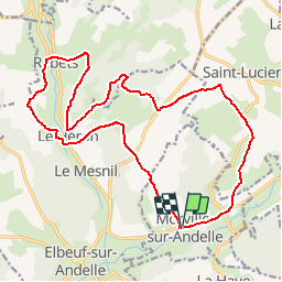
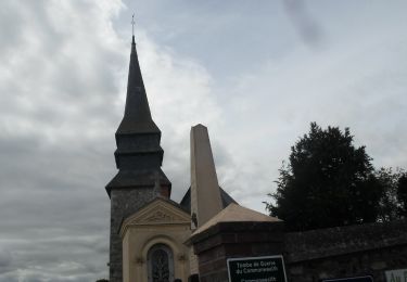
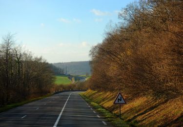
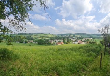
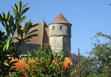
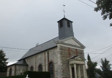
Randonnée Marche de 19,1 km à découvrir à Normandie, Seine-Maritime, Morville-sur-Andelle. Cette randonnée est proposée par tracegps.
Description
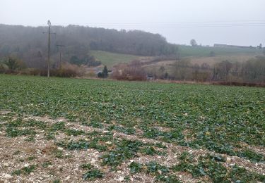
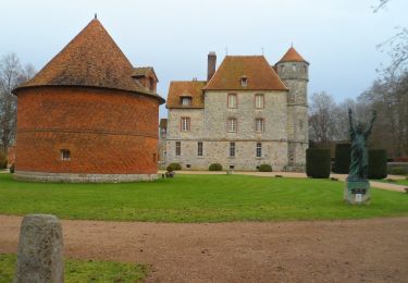
Superbe balade sur les hauteurs du Héron et de l'Andelle. Les paysages méritent amplement l'alternance de montées et de descentes de cette promenade que nous suivrons à nouveau aux beaux jours. A réserver aux bons marcheurs.
Localisation
Pays :
France
Région :
Normandie
Département/Province :
Seine-Maritime
Commune :
Morville-sur-Andelle
Localité :
Unknown
Départ:(Dec)
Départ:(UTM)
386174 ; 5481693 (31U) N.
Commentaires
Randonnées à proximité
![Randonnée Marche La Haye - La Haye (76) - Les Landez (Le Tronquay) - Photo](https://media.geolcdn.com/t/375/260/ext.jpg?maxdim=2&url=https%3A%2F%2Fstatic1.geolcdn.com%2Fsiteimages%2Fupload%2Ffiles%2F1553511878bg_sport_marche.png)
![Marche Marche](https://static1.geolcdn.com/sitytour/trail-icons/101.png)
La Haye (76) - Les Landez (Le Tronquay)
Marche
Très facile
(1)
La Haye,
Normandie,
Seine-Maritime,
France
![](/images/other/stat-length.png)
8,1 km | 10,4 km-effort
2h 15min
![](https://static1.geolcdn.com/siteimages/upload/files/16400158638029165_repeat_loop_refresh_sync_direction_icon.png)
Oui
![Randonnée Marche Nolléval - Nolléval - le Boulay - Photo](https://media.geolcdn.com/t/375/260/ext.jpg?maxdim=2&url=https%3A%2F%2Fstatic1.geolcdn.com%2Fsiteimages%2Fupload%2Ffiles%2F1553511878bg_sport_marche.png)
![Marche Marche](https://static1.geolcdn.com/sitytour/trail-icons/101.png)
Nolléval - le Boulay
Marche
Moyen
(2)
Nolléval,
Normandie,
Seine-Maritime,
France
![](/images/other/stat-length.png)
10,1 km | 14,1 km-effort
2h 56min
![](https://static1.geolcdn.com/siteimages/upload/files/16400158638029165_repeat_loop_refresh_sync_direction_icon.png)
Oui
![Randonnée Marche Le Héron - Rebets par l'Héronchelles - Photo](https://media.geolcdn.com/t/375/260/d3f3818d-0528-4506-9a5b-801bed775619.jpg&format=jpg&maxdim=2)
![Marche Marche](https://static1.geolcdn.com/sitytour/trail-icons/101.png)
Rebets par l'Héronchelles
Marche
Difficile
Le Héron,
Normandie,
Seine-Maritime,
France
![](/images/other/stat-length.png)
11,2 km | 15,2 km-effort
3h 7min
![](https://static1.geolcdn.com/siteimages/upload/files/16400158638029165_repeat_loop_refresh_sync_direction_icon.png)
Oui
![Marche Marche](https://static1.geolcdn.com/sitytour/trail-icons/101.png)
20231207-Vascoeuil
Marche
Moyen
Vascœuil,
Normandie,
Eure,
France
![](/images/other/stat-length.png)
10,9 km | 14,1 km-effort
3h 6min
![](https://static1.geolcdn.com/siteimages/upload/files/16400158638029165_repeat_loop_refresh_sync_direction_icon.png)
Oui
![Marche Marche](https://static1.geolcdn.com/sitytour/trail-icons/101.png)
20220823-Elbeuf sur Andelle
Marche
Moyen
Elbeuf-sur-Andelle,
Normandie,
Seine-Maritime,
France
![](/images/other/stat-length.png)
12,6 km | 15,9 km-effort
3h 23min
![](https://static1.geolcdn.com/siteimages/upload/files/16400158638029165_repeat_loop_refresh_sync_direction_icon.png)
Oui
![Randonnée A pied La Feuillie - Les Orchidées - Photo](https://media.geolcdn.com/t/375/260/56ec95b6-9ea1-40dd-91ba-a3a4e9ec6cc7.jpeg&format=jpg&maxdim=2)
![A pied A pied](https://static1.geolcdn.com/sitytour/trail-icons/100.png)
Les Orchidées
A pied
Facile
La Feuillie,
Normandie,
Seine-Maritime,
France
![](/images/other/stat-length.png)
9,3 km | 11,1 km-effort
2h 31min
![](https://static1.geolcdn.com/siteimages/upload/files/16400158638029165_repeat_loop_refresh_sync_direction_icon.png)
Oui
![Randonnée Marche Nolléval - 20210603-Nolléval - Photo](https://media.geolcdn.com/t/375/260/629e1398-d0c9-446f-bcbe-1d9a731ba8d8.jpg&format=jpg&maxdim=2)
![Marche Marche](https://static1.geolcdn.com/sitytour/trail-icons/101.png)
20210603-Nolléval
Marche
Moyen
Nolléval,
Normandie,
Seine-Maritime,
France
![](/images/other/stat-length.png)
20 km | 26 km-effort
6h 2min
![](https://static1.geolcdn.com/siteimages/upload/files/16400158638029165_repeat_loop_refresh_sync_direction_icon.png)
Oui
![Marche Marche](https://static1.geolcdn.com/sitytour/trail-icons/101.png)
20200804-Vascoeuil
Marche
Moyen
Vascœuil,
Normandie,
Eure,
France
![](/images/other/stat-length.png)
13,9 km | 17,7 km-effort
3h 47min
![](https://static1.geolcdn.com/siteimages/upload/files/16400158638029165_repeat_loop_refresh_sync_direction_icon.png)
Oui
![Marche Marche](https://static1.geolcdn.com/sitytour/trail-icons/101.png)
20191022-Le Héron-Elbeuf sur Andelle
Marche
Moyen
Elbeuf-sur-Andelle,
Normandie,
Seine-Maritime,
France
![](/images/other/stat-length.png)
11,9 km | 15,1 km-effort
3h 13min
![](https://static1.geolcdn.com/siteimages/upload/files/16400158638029165_repeat_loop_refresh_sync_direction_icon.png)
Oui