![](/images/other/stat-length.png)
![Randonnée V.T.T. Pagny-sur-Moselle - Vélo et Nature 2014 - Pagny sur Moselle - Photo](https://media.geolcdn.com/t/1900/400/ext.pjpeg?maxdim=2&url=https%3A%2F%2Fservices.sitytrail.com%2FGeolivesWS%2FDownloadMedia.ashx%3FTrailID%3D317805%26Media%3D17136_6.jpg)
Vélo et Nature 2014 - Pagny sur Moselle
tracegps
Utilisateur
![Longueur](/images/other/stat-length.png)
Longueur
34 km
![Altitude max](https://static1.geolcdn.com/siteimages/upload/files/1508320355ic_sort_altitude_max_24dp.png)
Altitude max
385 m
![Dénivelé positif](https://static1.geolcdn.com/siteimages/upload/files/1508320355ic_sort_den_pos_24dp.png)
Dénivelé positif
696 m
![Km-Effort](/images/other/stat-length.png)
Km-Effort
43 km
![Altitude min](https://static1.geolcdn.com/siteimages/upload/files/1508320355ic_sort_altitude_min_24dp.png)
Altitude min
186 m
![Dénivelé négatif](https://static1.geolcdn.com/siteimages/upload/files/1508320355ic_sort_den_neg_24dp.png)
Dénivelé négatif
696 m
![Boucle](https://static1.geolcdn.com/siteimages/upload/files/16400158638029165_repeat_loop_refresh_sync_direction_icon.png)
Boucle
Oui
Date de création :
2014-12-10 00:00:00.0
Dernière modification :
2014-12-10 00:00:00.0
![V.T.T.](https://static1.geolcdn.com/sitytour/trail-icons/202.png)
2h00
Difficulté : Moyen
![Scannez ce code QR pour ouvrir la randonnée dans l'application SityTrail](https://capi.geolives.com/qq0zvz2zws4bq2lad0pu/sitytour/trails/317805/qr.png?size=200)
Application GPS de randonnée GRATUITE
À propos
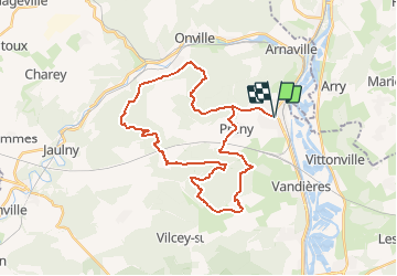
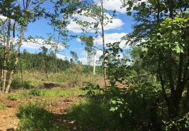
Randonnée V.T.T. de 34 km à découvrir à Grand Est, Meurthe-et-Moselle, Pagny-sur-Moselle. Cette randonnée est proposée par tracegps.
Description
Circuit proposé par Vélo et Nature de Pagny sur Moselle le 13 Avril 2014. Départ de la rue de la Victoire, près de l'église.
Localisation
Pays :
France
Région :
Grand Est
Département/Province :
Meurthe-et-Moselle
Commune :
Pagny-sur-Moselle
Localité :
Unknown
Départ:(Dec)
Départ:(UTM)
282016 ; 5429815 (32U) N.
Commentaires
Randonnées à proximité
![Randonnée A pied Arry - Circuit d'Arry Nord - Photo](https://media.geolcdn.com/t/375/260/3c0e2cec-70a5-424b-afe0-bda5787030da.jpeg&format=jpg&maxdim=2)
![A pied A pied](https://static1.geolcdn.com/sitytour/trail-icons/100.png)
![Randonnée Marche Pagny-sur-Moselle - Pagny sur Moselle - Photo](https://media.geolcdn.com/t/375/260/ext.jpg?maxdim=2&url=https%3A%2F%2Fstatic1.geolcdn.com%2Fsiteimages%2Fupload%2Ffiles%2F1553511878bg_sport_marche.png)
![Marche Marche](https://static1.geolcdn.com/sitytour/trail-icons/101.png)
Pagny sur Moselle
Marche
Très facile
(1)
Pagny-sur-Moselle,
Grand Est,
Meurthe-et-Moselle,
France
![](/images/other/stat-length.png)
18,1 km | 23 km-effort
4h 55min
![](https://static1.geolcdn.com/siteimages/upload/files/16400158638029165_repeat_loop_refresh_sync_direction_icon.png)
Oui
![Randonnée Marche Arry - Arry - côte Saint Pierre - Vezon - Marieulles - Lorry Mardigny - Arry - Photo](https://media.geolcdn.com/t/375/260/ff937aea-a994-4209-8ca1-ce9cd46d81d8.jpg&format=jpg&maxdim=2)
![Marche Marche](https://static1.geolcdn.com/sitytour/trail-icons/101.png)
Arry - côte Saint Pierre - Vezon - Marieulles - Lorry Mardigny - Arry
Marche
Moyen
Arry,
Grand Est,
Moselle,
France
![](/images/other/stat-length.png)
13,9 km | 18 km-effort
24h 12min
![](https://static1.geolcdn.com/siteimages/upload/files/16400158638029165_repeat_loop_refresh_sync_direction_icon.png)
Oui
![Randonnée Marche Champey-sur-Moselle - CHAMPEY - LA FRONTIERE - Photo](https://media.geolcdn.com/t/375/260/5293a82e-2a6e-43d7-9a10-ac23494bc253.jpg&format=jpg&maxdim=2)
![Marche Marche](https://static1.geolcdn.com/sitytour/trail-icons/101.png)
CHAMPEY - LA FRONTIERE
Marche
Facile
Champey-sur-Moselle,
Grand Est,
Meurthe-et-Moselle,
France
![](/images/other/stat-length.png)
10,7 km | 14,5 km-effort
3h 31min
![](https://static1.geolcdn.com/siteimages/upload/files/16400158638029165_repeat_loop_refresh_sync_direction_icon.png)
Oui
![Randonnée Marche Arnaville - ARNAVILLE - LES AÏTRES MEDIEVAUX - Photo](https://media.geolcdn.com/t/375/260/d37deaa3-5f14-412c-9d83-a46e5622a12e.jpg&format=jpg&maxdim=2)
![Marche Marche](https://static1.geolcdn.com/sitytour/trail-icons/101.png)
ARNAVILLE - LES AÏTRES MEDIEVAUX
Marche
Facile
Arnaville,
Grand Est,
Meurthe-et-Moselle,
France
![](/images/other/stat-length.png)
12,7 km | 15,6 km-effort
3h 51min
![](https://static1.geolcdn.com/siteimages/upload/files/16400158638029165_repeat_loop_refresh_sync_direction_icon.png)
Oui
![Randonnée Marche Arnaville - ARNAVILLE - LA VALLEE DU RUPT DE MAD - Photo](https://media.geolcdn.com/t/375/260/0c24bd03-483c-4f8f-b6a8-2e730119a0b2.jpg&format=jpg&maxdim=2)
![Marche Marche](https://static1.geolcdn.com/sitytour/trail-icons/101.png)
ARNAVILLE - LA VALLEE DU RUPT DE MAD
Marche
Facile
Arnaville,
Grand Est,
Meurthe-et-Moselle,
France
![](/images/other/stat-length.png)
9,9 km | 13,5 km-effort
3h 55min
![](https://static1.geolcdn.com/siteimages/upload/files/16400158638029165_repeat_loop_refresh_sync_direction_icon.png)
Oui
![Randonnée Marche Pagny-sur-Moselle - PAGNY SUR MOSELLE - VAL ET PLATEAU - Photo](https://media.geolcdn.com/t/375/260/dee2092b-e619-4a0a-95ba-1af28af57431.jpg&format=jpg&maxdim=2)
![Marche Marche](https://static1.geolcdn.com/sitytour/trail-icons/101.png)
PAGNY SUR MOSELLE - VAL ET PLATEAU
Marche
Moyen
Pagny-sur-Moselle,
Grand Est,
Meurthe-et-Moselle,
France
![](/images/other/stat-length.png)
18,1 km | 23 km-effort
6h 46min
![](https://static1.geolcdn.com/siteimages/upload/files/16400158638029165_repeat_loop_refresh_sync_direction_icon.png)
Oui
![Randonnée Marche Prény - Forêt de Preny dévastée quelle dommage - Photo](https://media.geolcdn.com/t/375/260/1f50b1f7-4c8a-4c2b-b85a-6e1416c0eb49.jpg&format=jpg&maxdim=2)
![Marche Marche](https://static1.geolcdn.com/sitytour/trail-icons/101.png)
Forêt de Preny dévastée quelle dommage
Marche
Moyen
Prény,
Grand Est,
Meurthe-et-Moselle,
France
![](/images/other/stat-length.png)
7,4 km | 9,7 km-effort
1h 14min
![](https://static1.geolcdn.com/siteimages/upload/files/16400158638029165_repeat_loop_refresh_sync_direction_icon.png)
Non
![Randonnée Marche Prény - Marche Prény 2017 - Photo](https://media.geolcdn.com/t/375/260/ext.jpg?maxdim=2&url=https%3A%2F%2Fstatic1.geolcdn.com%2Fsiteimages%2Fupload%2Ffiles%2F1553511878bg_sport_marche.png)
![Marche Marche](https://static1.geolcdn.com/sitytour/trail-icons/101.png)
Marche Prény 2017
Marche
Moyen
(1)
Prény,
Grand Est,
Meurthe-et-Moselle,
France
![](/images/other/stat-length.png)
9,5 km | 13 km-effort
2h 41min
![](https://static1.geolcdn.com/siteimages/upload/files/16400158638029165_repeat_loop_refresh_sync_direction_icon.png)
Oui