![](/images/other/stat-length.png)
![Randonnée Marche Iffendic - L'étang des landiers - Iffendic - Photo](https://media.geolcdn.com/t/1900/400/ext.pjpeg?maxdim=2&url=https%3A%2F%2Fservices.sitytrail.com%2FGeolivesWS%2FDownloadMedia.ashx%3FTrailID%3D317719%26Media%3D17030_5.jpg)
L'étang des landiers - Iffendic
tracegps
Utilisateur
![Longueur](/images/other/stat-length.png)
![Altitude max](https://static1.geolcdn.com/siteimages/upload/files/1508320355ic_sort_altitude_max_24dp.png)
![Dénivelé positif](https://static1.geolcdn.com/siteimages/upload/files/1508320355ic_sort_den_pos_24dp.png)
![Km-Effort](/images/other/stat-length.png)
![Altitude min](https://static1.geolcdn.com/siteimages/upload/files/1508320355ic_sort_altitude_min_24dp.png)
![Dénivelé négatif](https://static1.geolcdn.com/siteimages/upload/files/1508320355ic_sort_den_neg_24dp.png)
![Boucle](https://static1.geolcdn.com/siteimages/upload/files/16400158638029165_repeat_loop_refresh_sync_direction_icon.png)
![Marche](https://static1.geolcdn.com/sitytour/trail-icons/101.png)
3h00
Difficulté : Moyen
![Scannez ce code QR pour ouvrir la randonnée dans l'application SityTrail](https://capi.geolives.com/qq0zvz2zws4bq2lad0pu/sitytour/trails/317719/qr.png?size=200)
Application GPS de randonnée GRATUITE
À propos
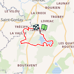
Randonnée Marche de 9,7 km à découvrir à Bretagne, Ille-et-Vilaine, Iffendic. Cette randonnée est proposée par tracegps.
Description
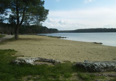
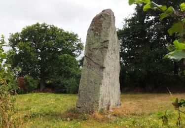
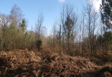
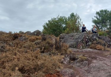
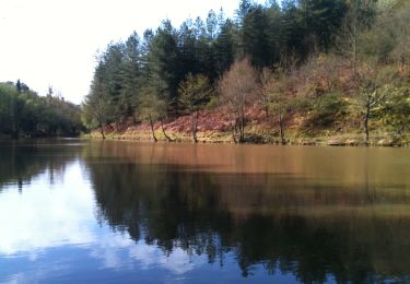
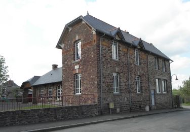
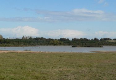
En forêt, dans les landiers, au bord d’un étang, le domaine de Trémelin point de départ du circuit et ses alentours offrent un espace idéal pour s’adonner aux joies de la randonnée. Depuis ce site, vous aurez accès à tout un réseau d’itinéraires dédié à la randonnée pédestre, mais aussi équestre et en VTT. Le domaine de Trémelin est un site naturel remarquable classé Zone Naturelle d’Intérêt Écologique Faunistique et Floristique (ZNIEFF). Vous pourrez notamment y observer de nombreuses espèces d’oiseaux. D’autre part, ce site est également dédié aux loisirs. Depuis la base implantée près de l’étang, vous pourrez pratiquer diverses activités comme l’accrobranche, le kayak ou la course d’orientation… Le corps de garde du Verger est un monument classé. Conseils aux randonneurs: A partir d’Iffendic, suivre les panneaux du camping de Trémelin. Le départ du circuit se situe près du parcours accrobranche. Retrouvez le circuit sur le site du Tourisme en Haute-Bretagne Ille-et-Vilaine. ou sur le site «balades.bretagne35.com» du Comité Départemental du Tourisme Haute Bretagne Ille-et-Vilaine.
Localisation
Commentaires
Randonnées à proximité
![Randonnée A pied Iffendic - Lac et landiers de Trémelin - Photo](https://media.geolcdn.com/t/375/260/7ac840cd-e5f1-4d8d-95cf-07084d9e8f75.jpeg&format=jpg&maxdim=2)
![A pied A pied](https://static1.geolcdn.com/sitytour/trail-icons/100.png)
A pied
![](/images/other/stat-length.png)
![](https://static1.geolcdn.com/siteimages/upload/files/16400158638029165_repeat_loop_refresh_sync_direction_icon.png)
![Randonnée A pied Iffendic - La Pierre Longue - Photo](https://media.geolcdn.com/t/375/260/8b094444-c6e7-42e6-b27a-c82fe025f95f.jpeg&format=jpg&maxdim=2)
![A pied A pied](https://static1.geolcdn.com/sitytour/trail-icons/100.png)
A pied
![](/images/other/stat-length.png)
![](https://static1.geolcdn.com/siteimages/upload/files/16400158638029165_repeat_loop_refresh_sync_direction_icon.png)
![Randonnée A pied Monterfil - Les Balcons de Monterfil - Photo](https://media.geolcdn.com/t/375/260/274d2856-8512-43c4-a2e1-3af681726e15.jpeg&format=jpg&maxdim=2)
![A pied A pied](https://static1.geolcdn.com/sitytour/trail-icons/100.png)
A pied
![](/images/other/stat-length.png)
![](https://static1.geolcdn.com/siteimages/upload/files/16400158638029165_repeat_loop_refresh_sync_direction_icon.png)
![Randonnée A pied Iffendic - Le Tour du Lac de Trémelin - Photo](https://media.geolcdn.com/t/375/260/b24516e3-87a2-4631-bc74-5cefab2c06d9.jpeg&format=jpg&maxdim=2)
![A pied A pied](https://static1.geolcdn.com/sitytour/trail-icons/100.png)
A pied
![](/images/other/stat-length.png)
![](https://static1.geolcdn.com/siteimages/upload/files/16400158638029165_repeat_loop_refresh_sync_direction_icon.png)
![Randonnée Marche Iffendic - GR_37_CC_37_Iffendic_Plelan-le-Grand_20220821 - Photo](https://media.geolcdn.com/t/375/260/a461a4e2-f121-4384-a36b-7fa282322953.jpg&format=jpg&maxdim=2)
![Marche Marche](https://static1.geolcdn.com/sitytour/trail-icons/101.png)
Marche
![](/images/other/stat-length.png)
![](https://static1.geolcdn.com/siteimages/upload/files/16400158638029165_repeat_loop_refresh_sync_direction_icon.png)
![Randonnée A pied Saint-Gonlay - Circuit de Lorinou - Photo](https://media.geolcdn.com/t/375/260/6659771c-e661-47f3-8cb5-3a3f13080ca5.jpeg&format=jpg&maxdim=2)
![A pied A pied](https://static1.geolcdn.com/sitytour/trail-icons/100.png)
A pied
![](/images/other/stat-length.png)
![](https://static1.geolcdn.com/siteimages/upload/files/16400158638029165_repeat_loop_refresh_sync_direction_icon.png)
![Randonnée A pied Saint-Gonlay - Chemin des Moulins - Photo](https://media.geolcdn.com/t/375/260/bc01016c-afeb-4a6c-a5c1-892106093006.jpeg&format=jpg&maxdim=2)
![A pied A pied](https://static1.geolcdn.com/sitytour/trail-icons/100.png)
A pied
![](/images/other/stat-length.png)
![](https://static1.geolcdn.com/siteimages/upload/files/16400158638029165_repeat_loop_refresh_sync_direction_icon.png)
![Randonnée A pied Iffendic - La Chambre-au-Loup - Photo](https://media.geolcdn.com/t/375/260/035739df-732e-4c49-94a4-b2bf0e9233ac.jpeg&format=jpg&maxdim=2)
![A pied A pied](https://static1.geolcdn.com/sitytour/trail-icons/100.png)
A pied
![](/images/other/stat-length.png)
![](https://static1.geolcdn.com/siteimages/upload/files/16400158638029165_repeat_loop_refresh_sync_direction_icon.png)
![Randonnée Marche Iffendic - La balade des deux étangs entre Trémelin et Careil - Iffendic - Photo](https://media.geolcdn.com/t/375/260/ext.jpg?maxdim=2&url=https%3A%2F%2Fservices.sitytrail.com%2FGeolivesWS%2FDownloadMedia.ashx%3FTrailID%3D317843%26Media%3D17217_5.jpg)
![Marche Marche](https://static1.geolcdn.com/sitytour/trail-icons/101.png)
Marche
![](/images/other/stat-length.png)
![](https://static1.geolcdn.com/siteimages/upload/files/16400158638029165_repeat_loop_refresh_sync_direction_icon.png)