![](/images/other/stat-length.png)
![Randonnée Marche Alsting - Les hauteurs d'Alsting - Zinzing - Photo](https://media.geolcdn.com/t/1900/400/ext.pjpeg?maxdim=2&url=https%3A%2F%2Fservices.sitytrail.com%2FGeolivesWS%2FDownloadMedia.ashx%3FTrailID%3D317676%26Media%3D16964_6.jpg)
Les hauteurs d'Alsting - Zinzing
tracegps
Utilisateur
![Longueur](/images/other/stat-length.png)
Longueur
16,2 km
![Altitude max](https://static1.geolcdn.com/siteimages/upload/files/1508320355ic_sort_altitude_max_24dp.png)
Altitude max
358 m
![Dénivelé positif](https://static1.geolcdn.com/siteimages/upload/files/1508320355ic_sort_den_pos_24dp.png)
Dénivelé positif
352 m
![Km-Effort](/images/other/stat-length.png)
Km-Effort
21 km
![Altitude min](https://static1.geolcdn.com/siteimages/upload/files/1508320355ic_sort_altitude_min_24dp.png)
Altitude min
204 m
![Dénivelé négatif](https://static1.geolcdn.com/siteimages/upload/files/1508320355ic_sort_den_neg_24dp.png)
Dénivelé négatif
351 m
![Boucle](https://static1.geolcdn.com/siteimages/upload/files/16400158638029165_repeat_loop_refresh_sync_direction_icon.png)
Boucle
Oui
Date de création :
2014-12-10 00:00:00.0
Dernière modification :
2014-12-10 00:00:00.0
![Marche](https://static1.geolcdn.com/sitytour/trail-icons/101.png)
4h10
Difficulté : Moyen
![Scannez ce code QR pour ouvrir la randonnée dans l'application SityTrail](https://capi.geolives.com/qq0zvz2zws4bq2lad0pu/sitytour/trails/317676/qr.png?size=200)
Application GPS de randonnée GRATUITE
À propos
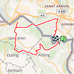
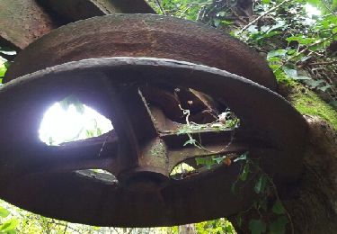
Randonnée Marche de 16,2 km à découvrir à Grand Est, Moselle, Alsting. Cette randonnée est proposée par tracegps.
Description
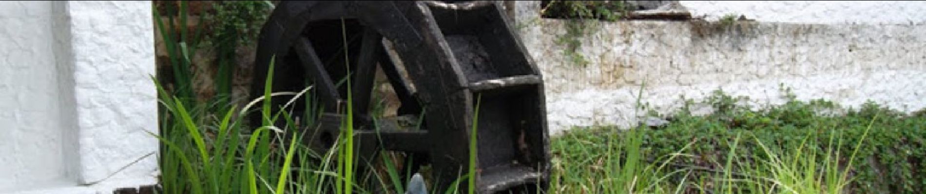
Simbach-Mühle, rue de Simbach à Alsting/Zinzing, vallée du Simbach, champ de bataille 1870 des hauts de Spicheren, sentier géologique calcaire à Alsting et grès à Sankt-Arnual. A midi, repas tiré du sac à Spicheren.
Localisation
Pays :
France
Région :
Grand Est
Département/Province :
Moselle
Commune :
Alsting
Localité :
Unknown
Départ:(Dec)
Départ:(UTM)
355624 ; 5450126 (32U) N.
Commentaires
Randonnées à proximité
![Randonnée A pied Sarrebruck - Rundweg Historischer Halberg - Photo](https://media.geolcdn.com/t/375/260/4559c55f-7c6f-4991-9ac9-1a91918d0127.jpeg&format=jpg&maxdim=2)
![A pied A pied](https://static1.geolcdn.com/sitytour/trail-icons/100.png)
Rundweg Historischer Halberg
A pied
Facile
Sarrebruck,
Sarre,
Regionalverband Saarbrücken,
Allemagne
![](/images/other/stat-length.png)
3 km | 4,2 km-effort
56min
![](https://static1.geolcdn.com/siteimages/upload/files/16400158638029165_repeat_loop_refresh_sync_direction_icon.png)
Non
![Randonnée A pied Kleinbliederstroff - Ölschleifenweg - Photo](https://media.geolcdn.com/t/375/260/70dd0f1f-60f6-4e83-9065-40ff0303d0c9.jpeg&format=jpg&maxdim=2)
![A pied A pied](https://static1.geolcdn.com/sitytour/trail-icons/100.png)
Ölschleifenweg
A pied
Facile
Kleinbliederstroff,
Sarre,
Regionalverband Saarbrücken,
Allemagne
![](/images/other/stat-length.png)
13,7 km | 17,6 km-effort
4h 0min
![](https://static1.geolcdn.com/siteimages/upload/files/16400158638029165_repeat_loop_refresh_sync_direction_icon.png)
Oui
![Randonnée A pied Kleinbliederstroff - Dragonerweg - Photo](https://media.geolcdn.com/t/375/260/2e69bdb5-5969-410d-986d-c26a26921515.jpeg&format=jpg&maxdim=2)
![A pied A pied](https://static1.geolcdn.com/sitytour/trail-icons/100.png)
Dragonerweg
A pied
Facile
Kleinbliederstroff,
Sarre,
Regionalverband Saarbrücken,
Allemagne
![](/images/other/stat-length.png)
4,7 km | 5,5 km-effort
1h 15min
![](https://static1.geolcdn.com/siteimages/upload/files/16400158638029165_repeat_loop_refresh_sync_direction_icon.png)
Non
![Randonnée Marche Lixing-lès-Rouhling - Sur les hauteurs de Grosbliederstroff - Lixing lès Rouhling - Photo](https://media.geolcdn.com/t/375/260/ext.jpg?maxdim=2&url=https%3A%2F%2Fservices.sitytrail.com%2FGeolivesWS%2FDownloadMedia.ashx%3FTrailID%3D317711%26Media%3D17019_6.jpg)
![Marche Marche](https://static1.geolcdn.com/sitytour/trail-icons/101.png)
Sur les hauteurs de Grosbliederstroff - Lixing lès Rouhling
Marche
Moyen
Lixing-lès-Rouhling,
Grand Est,
Moselle,
France
![](/images/other/stat-length.png)
14,3 km | 18,4 km-effort
3h 45min
![](https://static1.geolcdn.com/siteimages/upload/files/16400158638029165_repeat_loop_refresh_sync_direction_icon.png)
Oui
![Randonnée Vélo de route Behren-lès-Forbach - EXT60 Behren-01 - Photo](https://media.geolcdn.com/t/375/260/e1ef912f-5f2a-4000-b694-67357fd154cc.jpg&format=jpg&maxdim=2)
![Vélo de route Vélo de route](https://static1.geolcdn.com/sitytour/trail-icons/201.png)
EXT60 Behren-01
Vélo de route
Moyen
Behren-lès-Forbach,
Grand Est,
Moselle,
France
![](/images/other/stat-length.png)
60 km | 70 km-effort
2h 45min
![](https://static1.geolcdn.com/siteimages/upload/files/16400158638029165_repeat_loop_refresh_sync_direction_icon.png)
Oui
![Randonnée Marche Kerbach - Le petit tour de kerbach - Photo](https://media.geolcdn.com/t/375/260/9860b0d7-1867-4668-b6be-71175a3550a7.jpg&format=jpg&maxdim=2)
![Marche Marche](https://static1.geolcdn.com/sitytour/trail-icons/101.png)
Le petit tour de kerbach
Marche
Facile
Kerbach,
Grand Est,
Moselle,
France
![](/images/other/stat-length.png)
5,3 km | 6,5 km-effort
1h 20min
![](https://static1.geolcdn.com/siteimages/upload/files/16400158638029165_repeat_loop_refresh_sync_direction_icon.png)
Oui
![Randonnée Marche Spicheren - Eric Spicheren - Photo](https://media.geolcdn.com/t/375/260/ext.jpg?maxdim=2&url=https%3A%2F%2Fservices.sitytrail.com%2FGeolivesWS%2FDownloadMedia.ashx%3FTrailID%3D482711%26Media%3Dfix__20151017095930.jpg)
![Marche Marche](https://static1.geolcdn.com/sitytour/trail-icons/101.png)
Eric Spicheren
Marche
Facile
Spicheren,
Grand Est,
Moselle,
France
![](/images/other/stat-length.png)
14,1 km | 17,8 km-effort
4h 6min
![](https://static1.geolcdn.com/siteimages/upload/files/16400158638029165_repeat_loop_refresh_sync_direction_icon.png)
Oui
![Randonnée Vélo électrique Etzling - boucle etzling-cocheren-hoste-sarreguemines - Photo](https://media.geolcdn.com/t/375/260/ext.jpg?maxdim=2&url=https%3A%2F%2Fstatic1.geolcdn.com%2Fsiteimages%2Fupload%2Ffiles%2F1524743154velo.jpg)
![Vélo électrique Vélo électrique](https://static1.geolcdn.com/sitytour/trail-icons/205.png)
boucle etzling-cocheren-hoste-sarreguemines
Vélo électrique
Moyen
Etzling,
Grand Est,
Moselle,
France
![](/images/other/stat-length.png)
69 km | 83 km-effort
3h 34min
![](https://static1.geolcdn.com/siteimages/upload/files/16400158638029165_repeat_loop_refresh_sync_direction_icon.png)
Oui
![Randonnée Randonnée équestre Alsting - 2022-04-10-01 ACDV Balade à cheval autour d'Alsting - Photo](https://media.geolcdn.com/t/375/260/ext.jpg?maxdim=2&url=https%3A%2F%2Fstatic1.geolcdn.com%2Fsiteimages%2Fupload%2Ffiles%2F1524743154cheval.jpg)
![Randonnée équestre Randonnée équestre](https://static1.geolcdn.com/sitytour/trail-icons/301.png)
2022-04-10-01 ACDV Balade à cheval autour d'Alsting
Randonnée équestre
Difficile
Alsting,
Grand Est,
Moselle,
France
![](/images/other/stat-length.png)
29 km | 39 km-effort
5h 5min
![](https://static1.geolcdn.com/siteimages/upload/files/16400158638029165_repeat_loop_refresh_sync_direction_icon.png)
Oui