![](/images/other/stat-length.png)
![Randonnée Marche Boulbon - Frigolet et San Salvador - Boulbon - Photo](https://media.geolcdn.com/t/1900/400/ext.pjpeg?maxdim=2&url=https%3A%2F%2Fservices.sitytrail.com%2FGeolivesWS%2FDownloadMedia.ashx%3FTrailID%3D317547%26Media%3D16799_6.jpg)
Frigolet et San Salvador - Boulbon
tracegps
Utilisateur
![Longueur](/images/other/stat-length.png)
![Altitude max](https://static1.geolcdn.com/siteimages/upload/files/1508320355ic_sort_altitude_max_24dp.png)
![Dénivelé positif](https://static1.geolcdn.com/siteimages/upload/files/1508320355ic_sort_den_pos_24dp.png)
![Km-Effort](/images/other/stat-length.png)
![Altitude min](https://static1.geolcdn.com/siteimages/upload/files/1508320355ic_sort_altitude_min_24dp.png)
![Dénivelé négatif](https://static1.geolcdn.com/siteimages/upload/files/1508320355ic_sort_den_neg_24dp.png)
![Boucle](https://static1.geolcdn.com/siteimages/upload/files/16400158638029165_repeat_loop_refresh_sync_direction_icon.png)
![Marche](https://static1.geolcdn.com/sitytour/trail-icons/101.png)
2h30
Difficulté : Moyen
![Scannez ce code QR pour ouvrir la randonnée dans l'application SityTrail](https://capi.geolives.com/qq0zvz2zws4bq2lad0pu/sitytour/trails/317547/qr.png?size=200)
Application GPS de randonnée GRATUITE
À propos
Randonnée Marche de 12,3 km à découvrir à Provence-Alpes-Côte d'Azur, Bouches-du-Rhône, Boulbon. Cette randonnée est proposée par tracegps.
Description
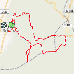
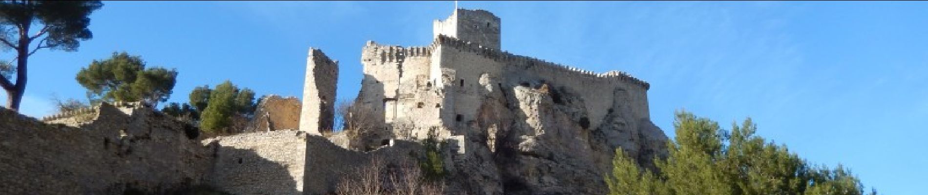
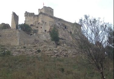
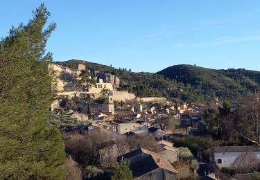
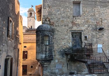
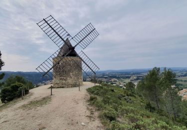
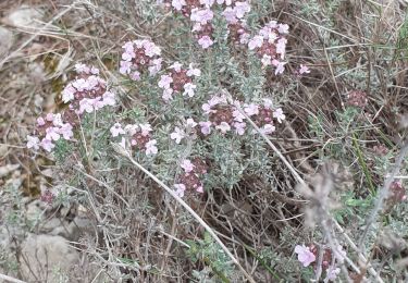
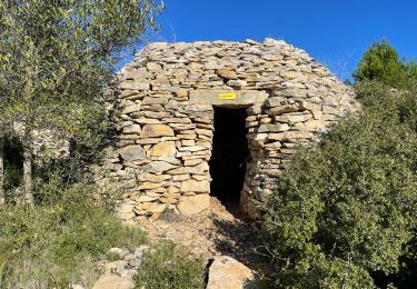
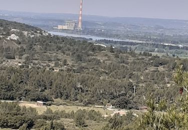
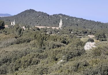
Une très belle rando au cœur de la Montagnette. Du parking en centre ville, prendre la rue de l’Eglise et arriver place Barberin Victor. Monter la rue Font de Bernard qui devient rapidement un sentier au fond d'un vallon, et faire un aller retour au portail du château. Le quitte par la gauche pour atteindre un Moulin. Cheminer par de bons chemins vers Frigolet, visiter puis poursuivre en direction de San Salvador, ne pas suivre le balisage. Vues grandioses sur la vallée du Rhône et le Ventoux, les Alpilles et la mer et la Camargue tout au long de ce parcours. Le retour peu emprunté, nécessite une grande attention sur la fin, pour trouver la bonne sente qui permet la descente vers le village; le GPS est très utile.
Localisation
Commentaires
Randonnées à proximité
![Randonnée Marche Boulbon - Boulbon PR40 - Photo](https://media.geolcdn.com/t/375/260/ext.jpg?maxdim=2&url=https%3A%2F%2Fservices.sitytrail.com%2FGeolivesWS%2FDownloadMedia.ashx%3FTrailID%3D233193%26Media%3D20131101145846.jpg)
![Marche Marche](https://static1.geolcdn.com/sitytour/trail-icons/101.png)
Marche
![](/images/other/stat-length.png)
![](https://static1.geolcdn.com/siteimages/upload/files/16400158638029165_repeat_loop_refresh_sync_direction_icon.png)
![Randonnée Marche Boulbon - Boulbon Barbentane Frigolet - Photo](https://media.geolcdn.com/t/375/260/db98e8af-4738-41d8-a5cc-4102fa5d0520.jpg&format=jpg&maxdim=2)
![Marche Marche](https://static1.geolcdn.com/sitytour/trail-icons/101.png)
Marche
![](/images/other/stat-length.png)
![](https://static1.geolcdn.com/siteimages/upload/files/16400158638029165_repeat_loop_refresh_sync_direction_icon.png)
![Randonnée A pied Boulbon - Boulbon et le Moulin Bonnet - Photo](https://media.geolcdn.com/t/375/260/ext.jpg?maxdim=2&url=https%3A%2F%2Fstatic1.geolcdn.com%2Fsiteimages%2Fupload%2Ffiles%2F1545311037marcheuse_200dpi.jpg)
![A pied A pied](https://static1.geolcdn.com/sitytour/trail-icons/100.png)
A pied
![](/images/other/stat-length.png)
![](https://static1.geolcdn.com/siteimages/upload/files/16400158638029165_repeat_loop_refresh_sync_direction_icon.png)
![Randonnée Marche Aramon - aramon - les castillonnes - Photo](https://media.geolcdn.com/t/375/260/631556ce-9f18-4093-a88d-7e024a6992af.jpg&format=jpg&maxdim=2)
![Marche Marche](https://static1.geolcdn.com/sitytour/trail-icons/101.png)
Marche
![](/images/other/stat-length.png)
![](https://static1.geolcdn.com/siteimages/upload/files/16400158638029165_repeat_loop_refresh_sync_direction_icon.png)
![Randonnée Marche Tarascon - PF-Tarascon - Saint-Michel-de-Frigolet - Moulin Bonnet - Boulbon - XA - 21.03.2022; 21 03 2022 - Photo](https://media.geolcdn.com/t/375/260/b8e241eb-ef04-456e-aea8-aa8c64b4ade3.jpg&format=jpg&maxdim=2)
![Marche Marche](https://static1.geolcdn.com/sitytour/trail-icons/101.png)
Marche
![](/images/other/stat-length.png)
![](https://static1.geolcdn.com/siteimages/upload/files/16400158638029165_repeat_loop_refresh_sync_direction_icon.png)
![Randonnée Marche Barbentane - Barbentane La Tour de Guet - Photo](https://media.geolcdn.com/t/375/260/ae2351a1-8ce3-4374-be17-9ab77a5cc2c6.jpg&format=jpg&maxdim=2)
![Marche Marche](https://static1.geolcdn.com/sitytour/trail-icons/101.png)
Marche
![](/images/other/stat-length.png)
![](https://static1.geolcdn.com/siteimages/upload/files/16400158638029165_repeat_loop_refresh_sync_direction_icon.png)
![Marche Marche](https://static1.geolcdn.com/sitytour/trail-icons/101.png)
Marche
![](/images/other/stat-length.png)
![](https://static1.geolcdn.com/siteimages/upload/files/16400158638029165_repeat_loop_refresh_sync_direction_icon.png)
![Randonnée Marche Boulbon - Boulbon Vallon des Cavaillonès - Photo](https://media.geolcdn.com/t/375/260/26ae9ef7-5be3-48ee-bebe-b9320bcbd58f.jpg&format=jpg&maxdim=2)
![Marche Marche](https://static1.geolcdn.com/sitytour/trail-icons/101.png)
Marche
![](/images/other/stat-length.png)
![](https://static1.geolcdn.com/siteimages/upload/files/16400158638029165_repeat_loop_refresh_sync_direction_icon.png)
![Randonnée Marche Tarascon - FRIGOLET Gratte Semelle - Photo](https://media.geolcdn.com/t/375/260/4245b54d-ccac-48c1-b4a1-cf4227c37eb7.jpg&format=jpg&maxdim=2)
![Marche Marche](https://static1.geolcdn.com/sitytour/trail-icons/101.png)
Marche
![](/images/other/stat-length.png)
![](https://static1.geolcdn.com/siteimages/upload/files/16400158638029165_repeat_loop_refresh_sync_direction_icon.png)