![](/images/other/stat-length.png)
![Randonnée Marche Mazières-de-Touraine - Sentier de randonnée n° 5 de Mazières-de-Touraine - Photo](https://media.geolcdn.com/t/1900/400/ext.pjpeg?maxdim=2&url=https%3A%2F%2Fservices.sitytrail.com%2FGeolivesWS%2FDownloadMedia.ashx%3FTrailID%3D317504%26Media%3D16741_2.jpg)
Sentier de randonnée n° 5 de Mazières-de-Touraine
tracegps
Utilisateur
![Longueur](/images/other/stat-length.png)
Longueur
24 km
![Altitude max](https://static1.geolcdn.com/siteimages/upload/files/1508320355ic_sort_altitude_max_24dp.png)
Altitude max
113 m
![Dénivelé positif](https://static1.geolcdn.com/siteimages/upload/files/1508320355ic_sort_den_pos_24dp.png)
Dénivelé positif
233 m
![Km-Effort](/images/other/stat-length.png)
Km-Effort
27 km
![Altitude min](https://static1.geolcdn.com/siteimages/upload/files/1508320355ic_sort_altitude_min_24dp.png)
Altitude min
59 m
![Dénivelé négatif](https://static1.geolcdn.com/siteimages/upload/files/1508320355ic_sort_den_neg_24dp.png)
Dénivelé négatif
234 m
![Boucle](https://static1.geolcdn.com/siteimages/upload/files/16400158638029165_repeat_loop_refresh_sync_direction_icon.png)
Boucle
Oui
Date de création :
2014-12-10 00:00:00.0
Dernière modification :
2014-12-10 00:00:00.0
![Marche](https://static1.geolcdn.com/sitytour/trail-icons/101.png)
6h00
Difficulté : Difficile
![Scannez ce code QR pour ouvrir la randonnée dans l'application SityTrail](https://capi.geolives.com/qq0zvz2zws4bq2lad0pu/sitytour/trails/317504/qr.png?size=200)
Application GPS de randonnée GRATUITE
À propos
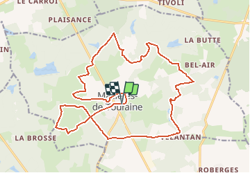
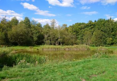
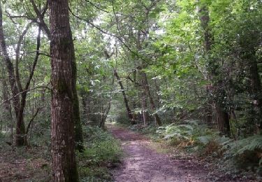
Randonnée Marche de 24 km à découvrir à Centre-Val de Loire, Indre-et-Loire, Mazières-de-Touraine. Cette randonnée est proposée par tracegps.
Description
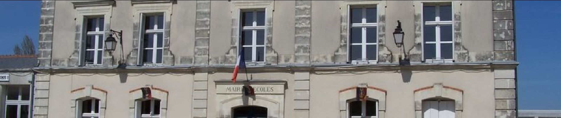
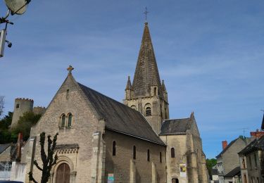
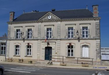
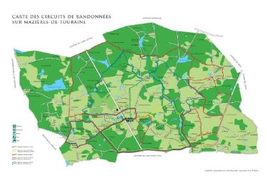
Circuit proposé par la commune de Mazières de Touraine. Départ de l’église de Mazières-de-Touraine. Retrouvez le la carte des circuits sur le site de la commune.
Localisation
Pays :
France
Région :
Centre-Val de Loire
Département/Province :
Indre-et-Loire
Commune :
Mazières-de-Touraine
Localité :
Unknown
Départ:(Dec)
Départ:(UTM)
305757 ; 5250969 (31T) N.
Commentaires
Randonnées à proximité
![Randonnée Marche Cinq-Mars-la-Pile - Cinq-Mars-la-Pile - Langeais - 14km 205m 3h05 - 2024 02 14 - Photo](https://media.geolcdn.com/t/375/260/bfe42b2e-405a-46df-8533-fbac70b0d338.jpg&format=jpg&maxdim=2)
![Marche Marche](https://static1.geolcdn.com/sitytour/trail-icons/101.png)
Cinq-Mars-la-Pile - Langeais - 14km 205m 3h05 - 2024 02 14
Marche
Facile
Cinq-Mars-la-Pile,
Centre-Val de Loire,
Indre-et-Loire,
France
![](/images/other/stat-length.png)
14 km | 16,7 km-effort
3h 5min
![](https://static1.geolcdn.com/siteimages/upload/files/16400158638029165_repeat_loop_refresh_sync_direction_icon.png)
Oui
![Randonnée Marche Cléré-les-Pins - Cléré-les-Pins - GRP Castelvalérie - 13.4km 90m 2h50 - 2023 03 25 - Photo](https://media.geolcdn.com/t/375/260/7fa6ca64-cfb4-4459-9a76-2d0948898d97.jpg&format=jpg&maxdim=2)
![Marche Marche](https://static1.geolcdn.com/sitytour/trail-icons/101.png)
Cléré-les-Pins - GRP Castelvalérie - 13.4km 90m 2h50 - 2023 03 25
Marche
Facile
Cléré-les-Pins,
Centre-Val de Loire,
Indre-et-Loire,
France
![](/images/other/stat-length.png)
13,4 km | 14,6 km-effort
2h 50min
![](https://static1.geolcdn.com/siteimages/upload/files/16400158638029165_repeat_loop_refresh_sync_direction_icon.png)
Oui
![Randonnée Marche Cinq-Mars-la-Pile - Cinq-Mars-la-Pile - le Mortier Rougeau - 19.5km 265m 4h30 - 2022 04 17 - Photo](https://media.geolcdn.com/t/375/260/f382cab4-57ba-447e-b146-a35d4860c6b9.jpg&format=jpg&maxdim=2)
![Marche Marche](https://static1.geolcdn.com/sitytour/trail-icons/101.png)
Cinq-Mars-la-Pile - le Mortier Rougeau - 19.5km 265m 4h30 - 2022 04 17
Marche
Facile
Cinq-Mars-la-Pile,
Centre-Val de Loire,
Indre-et-Loire,
France
![](/images/other/stat-length.png)
19,7 km | 23 km-effort
4h 30min
![](https://static1.geolcdn.com/siteimages/upload/files/16400158638029165_repeat_loop_refresh_sync_direction_icon.png)
Oui
![Randonnée Marche Mazières-de-Touraine - Mazières-de-Touraine - Ruisseau du Breuil - 17.3km 200m 4h20 - 2020 09 09 - Photo](https://media.geolcdn.com/t/375/260/f1d013cb-af38-48a9-aea1-dfc2388ff089.jpg&format=jpg&maxdim=2)
![Marche Marche](https://static1.geolcdn.com/sitytour/trail-icons/101.png)
Mazières-de-Touraine - Ruisseau du Breuil - 17.3km 200m 4h20 - 2020 09 09
Marche
Facile
Mazières-de-Touraine,
Centre-Val de Loire,
Indre-et-Loire,
France
![](/images/other/stat-length.png)
17,3 km | 19,9 km-effort
4h 20min
![](https://static1.geolcdn.com/siteimages/upload/files/16400158638029165_repeat_loop_refresh_sync_direction_icon.png)
Oui
![Randonnée Marche Mazières-de-Touraine - maître jaune et variante - Photo](https://media.geolcdn.com/t/375/260/ext.jpg?maxdim=2&url=https%3A%2F%2Fstatic1.geolcdn.com%2Fsiteimages%2Fupload%2Ffiles%2F1553511878bg_sport_marche.png)
![Marche Marche](https://static1.geolcdn.com/sitytour/trail-icons/101.png)
maître jaune et variante
Marche
Très facile
(1)
Mazières-de-Touraine,
Centre-Val de Loire,
Indre-et-Loire,
France
![](/images/other/stat-length.png)
11,5 km | 13,1 km-effort
2h 30min
![](https://static1.geolcdn.com/siteimages/upload/files/16400158638029165_repeat_loop_refresh_sync_direction_icon.png)
Oui
![Randonnée Marche Mazières-de-Touraine - maziere de Touraine - Photo](https://media.geolcdn.com/t/375/260/ext.jpg?maxdim=2&url=https%3A%2F%2Fservices.sitytrail.com%2FGeolivesWS%2FDownloadMedia.ashx%3FTrailID%3D332574%26Media%3Dfix__20140809125412.jpg)
![Marche Marche](https://static1.geolcdn.com/sitytour/trail-icons/101.png)
maziere de Touraine
Marche
Moyen
Mazières-de-Touraine,
Centre-Val de Loire,
Indre-et-Loire,
France
![](/images/other/stat-length.png)
16,1 km | 18,5 km-effort
3h 33min
![](https://static1.geolcdn.com/siteimages/upload/files/16400158638029165_repeat_loop_refresh_sync_direction_icon.png)
Oui
![Randonnée Marche Mazières-de-Touraine - Sentier de randonnée n° 5 bis de Mazières-de-Touraine - Photo](https://media.geolcdn.com/t/375/260/ext.jpg?maxdim=2&url=https%3A%2F%2Fservices.sitytrail.com%2FGeolivesWS%2FDownloadMedia.ashx%3FTrailID%3D317505%26Media%3D16742_3.jpg)
![Marche Marche](https://static1.geolcdn.com/sitytour/trail-icons/101.png)
Sentier de randonnée n° 5 bis de Mazières-de-Touraine
Marche
Difficile
Mazières-de-Touraine,
Centre-Val de Loire,
Indre-et-Loire,
France
![](/images/other/stat-length.png)
21 km | 24 km-effort
5h 15min
![](https://static1.geolcdn.com/siteimages/upload/files/16400158638029165_repeat_loop_refresh_sync_direction_icon.png)
Oui
![Randonnée Marche Mazières-de-Touraine - Sentier de randonnée n° 4 de Mazières-de-Touraine - Photo](https://media.geolcdn.com/t/375/260/ext.jpg?maxdim=2&url=https%3A%2F%2Fservices.sitytrail.com%2FGeolivesWS%2FDownloadMedia.ashx%3FTrailID%3D317431%26Media%3D16666_1.jpg)
![Marche Marche](https://static1.geolcdn.com/sitytour/trail-icons/101.png)
Sentier de randonnée n° 4 de Mazières-de-Touraine
Marche
Difficile
Mazières-de-Touraine,
Centre-Val de Loire,
Indre-et-Loire,
France
![](/images/other/stat-length.png)
30 km | 33 km-effort
7h 30min
![](https://static1.geolcdn.com/siteimages/upload/files/16400158638029165_repeat_loop_refresh_sync_direction_icon.png)
Oui
![Randonnée Marche Mazières-de-Touraine - Sentier de randonnée n° 3 de Mazières de Touraine - Photo](https://media.geolcdn.com/t/375/260/ext.jpg?maxdim=2&url=https%3A%2F%2Fservices.sitytrail.com%2FGeolivesWS%2FDownloadMedia.ashx%3FTrailID%3D112262%26Media%3D10244_4.jpg)
![Marche Marche](https://static1.geolcdn.com/sitytour/trail-icons/101.png)
Sentier de randonnée n° 3 de Mazières de Touraine
Marche
Facile
(1)
Mazières-de-Touraine,
Centre-Val de Loire,
Indre-et-Loire,
France
![](/images/other/stat-length.png)
3 km | 3,5 km-effort
45min
![](https://static1.geolcdn.com/siteimages/upload/files/16400158638029165_repeat_loop_refresh_sync_direction_icon.png)
Oui