![](/images/other/stat-length.png)
![Randonnée Marche Valensole - 1Chapelle Sainte Madeleine, Villedieu. - Photo](https://media.geolcdn.com/t/1900/400/388f6884-2209-4f6a-acdc-4648387b9294.jpg&format=pjpeg&maxdim=2)
1Chapelle Sainte Madeleine, Villedieu.
liocol
Utilisateur
![Longueur](/images/other/stat-length.png)
Longueur
8 km
![Altitude max](https://static1.geolcdn.com/siteimages/upload/files/1508320355ic_sort_altitude_max_24dp.png)
Altitude max
488 m
![Dénivelé positif](https://static1.geolcdn.com/siteimages/upload/files/1508320355ic_sort_den_pos_24dp.png)
Dénivelé positif
208 m
![Km-Effort](/images/other/stat-length.png)
Km-Effort
10,8 km
![Altitude min](https://static1.geolcdn.com/siteimages/upload/files/1508320355ic_sort_altitude_min_24dp.png)
Altitude min
319 m
![Dénivelé négatif](https://static1.geolcdn.com/siteimages/upload/files/1508320355ic_sort_den_neg_24dp.png)
Dénivelé négatif
206 m
![Boucle](https://static1.geolcdn.com/siteimages/upload/files/16400158638029165_repeat_loop_refresh_sync_direction_icon.png)
Boucle
Oui
Date de création :
2022-03-21 08:19:56.281
Dernière modification :
2022-03-21 16:02:32.018
![Marche](https://static1.geolcdn.com/sitytour/trail-icons/101.png)
2h28
Difficulté : Moyen
![Scannez ce code QR pour ouvrir la randonnée dans l'application SityTrail](https://capi.geolives.com/qq0zvz2zws4bq2lad0pu/sitytour/trails/3175024/qr.png?size=200)
Application GPS de randonnée GRATUITE
À propos
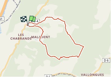
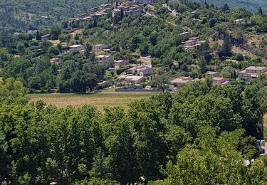
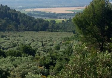
Randonnée Marche de 8 km à découvrir à Provence-Alpes-Côte d'Azur, Alpes-de-Haute-Provence, Valensole. Cette randonnée est proposée par liocol.
Description
Aux 4 chemins, prenez la D4, à droite, 1 km après le Fuste.
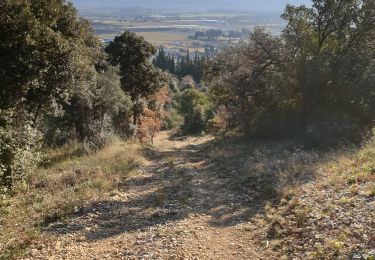
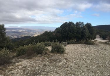
Une partie du circuit est hors piste, suivez le GPS.
Localisation
Pays :
France
Région :
Provence-Alpes-Côte d'Azur
Département/Province :
Alpes-de-Haute-Provence
Commune :
Valensole
Localité :
Unknown
Départ:(Dec)
Départ:(UTM)
729801 ; 4856603 (31T) N.
Commentaires
Randonnées à proximité
![Randonnée Trail Volx - volx - Photo](https://media.geolcdn.com/t/375/260/074b6f13-4b46-4d5f-9210-d6f66b960796.jpg&format=jpg&maxdim=2)
![Trail Trail](https://static1.geolcdn.com/sitytour/trail-icons/104.png)
volx
Trail
Difficile
Volx,
Provence-Alpes-Côte d'Azur,
Alpes-de-Haute-Provence,
France
![](/images/other/stat-length.png)
9,2 km | 14,7 km-effort
1h 43min
![](https://static1.geolcdn.com/siteimages/upload/files/16400158638029165_repeat_loop_refresh_sync_direction_icon.png)
Oui
![Randonnée Marche Gréoux-les-Bains - 1Callelongue, vers Valensole - Photo](https://media.geolcdn.com/t/375/260/d61398aa-55fc-417c-af91-29f20f3e5e09.jpg&format=jpg&maxdim=2)
![Marche Marche](https://static1.geolcdn.com/sitytour/trail-icons/101.png)
1Callelongue, vers Valensole
Marche
Moyen
Gréoux-les-Bains,
Provence-Alpes-Côte d'Azur,
Alpes-de-Haute-Provence,
France
![](/images/other/stat-length.png)
9 km | 11,3 km-effort
2h 32min
![](https://static1.geolcdn.com/siteimages/upload/files/16400158638029165_repeat_loop_refresh_sync_direction_icon.png)
Oui
![Randonnée V.T.C. Volx - 04 - Volx - Photo](https://media.geolcdn.com/t/375/260/2fa7cf4a-5d1b-4d88-b9b5-62454dc4bb5a.jpg&format=jpg&maxdim=2)
![V.T.C. V.T.C.](https://static1.geolcdn.com/sitytour/trail-icons/203.png)
04 - Volx
V.T.C.
Facile
Volx,
Provence-Alpes-Côte d'Azur,
Alpes-de-Haute-Provence,
France
![](/images/other/stat-length.png)
38 km | 47 km-effort
3h 30min
![](https://static1.geolcdn.com/siteimages/upload/files/16400158638029165_repeat_loop_refresh_sync_direction_icon.png)
Oui
![Randonnée Marche Manosque - La Tour du Mont d'Or - Photo](https://media.geolcdn.com/t/375/260/05feeeed-f568-48d5-831f-f28c8e3195ef.jpg&format=jpg&maxdim=2)
![Marche Marche](https://static1.geolcdn.com/sitytour/trail-icons/101.png)
La Tour du Mont d'Or
Marche
Très facile
Manosque,
Provence-Alpes-Côte d'Azur,
Alpes-de-Haute-Provence,
France
![](/images/other/stat-length.png)
5,9 km | 8,6 km-effort
1h 43min
![](https://static1.geolcdn.com/siteimages/upload/files/16400158638029165_repeat_loop_refresh_sync_direction_icon.png)
Oui
![Randonnée Vélo électrique Manosque - Manosque - Volx par le col de la mort d'Imbert - Photo](https://media.geolcdn.com/t/375/260/ec7aca07-5412-4430-8ed7-f5bdad5d34ca.jpg&format=jpg&maxdim=2)
![Vélo électrique Vélo électrique](https://static1.geolcdn.com/sitytour/trail-icons/205.png)
Manosque - Volx par le col de la mort d'Imbert
Vélo électrique
Manosque,
Provence-Alpes-Côte d'Azur,
Alpes-de-Haute-Provence,
France
![](/images/other/stat-length.png)
30 km | 39 km-effort
2h 14min
![](https://static1.geolcdn.com/siteimages/upload/files/16400158638029165_repeat_loop_refresh_sync_direction_icon.png)
Oui
![Randonnée Camping-car Manosque - Le canal du midi et plus beaux villages de France - Photo](https://media.geolcdn.com/t/375/260/fe78c90b-da31-464b-a7ab-e8275a1deca5.jpg&format=jpg&maxdim=2)
![Camping-car Camping-car](https://static1.geolcdn.com/sitytour/trail-icons/405.png)
Le canal du midi et plus beaux villages de France
Camping-car
Très facile
Manosque,
Provence-Alpes-Côte d'Azur,
Alpes-de-Haute-Provence,
France
![](/images/other/stat-length.png)
1582 km | 2089 km-effort
Inconnu
![](https://static1.geolcdn.com/siteimages/upload/files/16400158638029165_repeat_loop_refresh_sync_direction_icon.png)
Oui
![Randonnée Marche Volx - Volx, les Margaridètes.Départ camping - Photo](https://media.geolcdn.com/t/375/260/ext.jpg?maxdim=2&url=https%3A%2F%2Fservices.sitytrail.com%2FGeolivesWS%2FDownloadMedia.ashx%3FTrailID%3D990030%26Media%3Dfix__20180620093651.jpg)
![Marche Marche](https://static1.geolcdn.com/sitytour/trail-icons/101.png)
Volx, les Margaridètes.Départ camping
Marche
Facile
Volx,
Provence-Alpes-Côte d'Azur,
Alpes-de-Haute-Provence,
France
![](/images/other/stat-length.png)
4,9 km | 8,2 km-effort
1h 42min
![](https://static1.geolcdn.com/siteimages/upload/files/16400158638029165_repeat_loop_refresh_sync_direction_icon.png)
Oui
![Randonnée Vélo Manosque - Manosque: Bastide des Jourdans - Montfuron - Photo](https://media.geolcdn.com/t/375/260/ext.jpg?maxdim=2&url=https%3A%2F%2Fstatic1.geolcdn.com%2Fsiteimages%2Fupload%2Ffiles%2F1524743154velo.jpg)
![Vélo Vélo](https://static1.geolcdn.com/sitytour/trail-icons/200.png)
Manosque: Bastide des Jourdans - Montfuron
Vélo
Moyen
(1)
Manosque,
Provence-Alpes-Côte d'Azur,
Alpes-de-Haute-Provence,
France
![](/images/other/stat-length.png)
40 km | 49 km-effort
2h 47min
![](https://static1.geolcdn.com/siteimages/upload/files/16400158638029165_repeat_loop_refresh_sync_direction_icon.png)
Oui
![Randonnée Marche Manosque - lac de pêche - Photo](https://media.geolcdn.com/t/375/260/ba46d756-df9d-4ac7-a46d-06a8cd622402.jpg&format=jpg&maxdim=2)
![Marche Marche](https://static1.geolcdn.com/sitytour/trail-icons/101.png)
lac de pêche
Marche
Facile
Manosque,
Provence-Alpes-Côte d'Azur,
Alpes-de-Haute-Provence,
France
![](/images/other/stat-length.png)
5,5 km | 6 km-effort
1h 51min
![](https://static1.geolcdn.com/siteimages/upload/files/16400158638029165_repeat_loop_refresh_sync_direction_icon.png)
Oui