![](/images/other/stat-length.png)
![Randonnée V.T.T. Saint-Symphorien - Forêt de la Petite Charnie - Saint-Symphorien - Photo](https://media.geolcdn.com/t/1900/400/ext.pjpeg?maxdim=2&url=https%3A%2F%2Fservices.sitytrail.com%2FGeolivesWS%2FDownloadMedia.ashx%3FTrailID%3D317404%26Media%3D16625_5.jpg)
Forêt de la Petite Charnie - Saint-Symphorien
tracegps
Utilisateur
![Longueur](/images/other/stat-length.png)
Longueur
19,3 km
![Altitude max](https://static1.geolcdn.com/siteimages/upload/files/1508320355ic_sort_altitude_max_24dp.png)
Altitude max
193 m
![Dénivelé positif](https://static1.geolcdn.com/siteimages/upload/files/1508320355ic_sort_den_pos_24dp.png)
Dénivelé positif
249 m
![Km-Effort](/images/other/stat-length.png)
Km-Effort
23 km
![Altitude min](https://static1.geolcdn.com/siteimages/upload/files/1508320355ic_sort_altitude_min_24dp.png)
Altitude min
114 m
![Dénivelé négatif](https://static1.geolcdn.com/siteimages/upload/files/1508320355ic_sort_den_neg_24dp.png)
Dénivelé négatif
248 m
![Boucle](https://static1.geolcdn.com/siteimages/upload/files/16400158638029165_repeat_loop_refresh_sync_direction_icon.png)
Boucle
Oui
Date de création :
2014-12-10 00:00:00.0
Dernière modification :
2014-12-10 00:00:00.0
![V.T.T.](https://static1.geolcdn.com/sitytour/trail-icons/202.png)
1h34
Difficulté : Moyen
![Scannez ce code QR pour ouvrir la randonnée dans l'application SityTrail](https://capi.geolives.com/qq0zvz2zws4bq2lad0pu/sitytour/trails/317404/qr.png?size=200)
Application GPS de randonnée GRATUITE
À propos
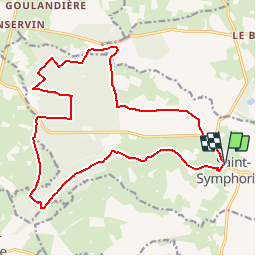
Randonnée V.T.T. de 19,3 km à découvrir à Pays de la Loire, Sarthe, Saint-Symphorien. Cette randonnée est proposée par tracegps.
Description
Circuit avec 6km de route, sinon le reste se trouve en forêt, très agréable et facile. Crédit photos: BORDEAU Alain.
Localisation
Pays :
France
Région :
Pays de la Loire
Département/Province :
Sarthe
Commune :
Saint-Symphorien
Localité :
Unknown
Départ:(Dec)
Départ:(UTM)
714775 ; 5328464 (30U) N.
Commentaires
Randonnées à proximité
![Randonnée V.T.T. Épineu-le-Chevreuil - circuit des passerelles - Photo](https://media.geolcdn.com/t/375/260/ext.jpg?maxdim=2&url=https%3A%2F%2Fstatic1.geolcdn.com%2Fsiteimages%2Fupload%2Ffiles%2F1524743154velo.jpg)
![V.T.T. V.T.T.](https://static1.geolcdn.com/sitytour/trail-icons/202.png)
circuit des passerelles
V.T.T.
Moyen
Épineu-le-Chevreuil,
Pays de la Loire,
Sarthe,
France
![](/images/other/stat-length.png)
17,5 km | 20 km-effort
1h 39min
![](https://static1.geolcdn.com/siteimages/upload/files/16400158638029165_repeat_loop_refresh_sync_direction_icon.png)
Oui
![Randonnée Marche nordique Tennie - FR Tennie 06-04-2021 Solo - Photo](https://media.geolcdn.com/t/375/260/ext.jpg?maxdim=2&url=https%3A%2F%2Fstatic1.geolcdn.com%2Fsiteimages%2Fupload%2Ffiles%2F1545311037marcheuse_200dpi.jpg)
![Marche nordique Marche nordique](https://static1.geolcdn.com/sitytour/trail-icons/102.png)
FR Tennie 06-04-2021 Solo
Marche nordique
Très facile
Tennie,
Pays de la Loire,
Sarthe,
France
![](/images/other/stat-length.png)
11,3 km | 12,8 km-effort
2h 28min
![](https://static1.geolcdn.com/siteimages/upload/files/16400158638029165_repeat_loop_refresh_sync_direction_icon.png)
Oui
![Randonnée Marche nordique Tennie - Fr Tennie G Petite rando 22-10-2019 6.5 Km - Photo](https://media.geolcdn.com/t/375/260/ext.jpg?maxdim=2&url=https%3A%2F%2Fstatic1.geolcdn.com%2Fsiteimages%2Fupload%2Ffiles%2F1545311037marcheuse_200dpi.jpg)
![Marche nordique Marche nordique](https://static1.geolcdn.com/sitytour/trail-icons/102.png)
Fr Tennie G Petite rando 22-10-2019 6.5 Km
Marche nordique
Très facile
Tennie,
Pays de la Loire,
Sarthe,
France
![](/images/other/stat-length.png)
6,4 km | 7,4 km-effort
1h 23min
![](https://static1.geolcdn.com/siteimages/upload/files/16400158638029165_repeat_loop_refresh_sync_direction_icon.png)
Non
![Randonnée Marche nordique Tennie - Tennie C - Photo](https://media.geolcdn.com/t/375/260/ext.jpg?maxdim=2&url=https%3A%2F%2Fstatic1.geolcdn.com%2Fsiteimages%2Fupload%2Ffiles%2F1545311037marcheuse_200dpi.jpg)
![Marche nordique Marche nordique](https://static1.geolcdn.com/sitytour/trail-icons/102.png)
Tennie C
Marche nordique
Très facile
Tennie,
Pays de la Loire,
Sarthe,
France
![](/images/other/stat-length.png)
11,4 km | 12,7 km-effort
Inconnu
![](https://static1.geolcdn.com/siteimages/upload/files/16400158638029165_repeat_loop_refresh_sync_direction_icon.png)
Oui
![Randonnée Marche nordique Tennie - Tennie. MR 13-07-2024 7 km - Photo](https://media.geolcdn.com/t/375/260/ext.jpg?maxdim=2&url=https%3A%2F%2Fstatic1.geolcdn.com%2Fsiteimages%2Fupload%2Ffiles%2F1545311037marcheuse_200dpi.jpg)
![Marche nordique Marche nordique](https://static1.geolcdn.com/sitytour/trail-icons/102.png)
Tennie. MR 13-07-2024 7 km
Marche nordique
Très facile
Tennie,
Pays de la Loire,
Sarthe,
France
![](/images/other/stat-length.png)
6,7 km | 7,6 km-effort
1h 41min
![](https://static1.geolcdn.com/siteimages/upload/files/16400158638029165_repeat_loop_refresh_sync_direction_icon.png)
Non
![Randonnée Marche nordique Bernay-Neuvy-en-Champagne - Fr Bernay 25-06-2025 MR - Photo](https://media.geolcdn.com/t/375/260/ext.jpg?maxdim=2&url=https%3A%2F%2Fstatic1.geolcdn.com%2Fsiteimages%2Fupload%2Ffiles%2F1545311037marcheuse_200dpi.jpg)
![Marche nordique Marche nordique](https://static1.geolcdn.com/sitytour/trail-icons/102.png)
Fr Bernay 25-06-2025 MR
Marche nordique
Très facile
Bernay-Neuvy-en-Champagne,
Pays de la Loire,
Sarthe,
France
![](/images/other/stat-length.png)
7,8 km | 8,6 km-effort
1h 38min
![](https://static1.geolcdn.com/siteimages/upload/files/16400158638029165_repeat_loop_refresh_sync_direction_icon.png)
Oui
![Randonnée Marche Parennes - Sortie en forêt petite charnière - Photo](https://media.geolcdn.com/t/375/260/ext.jpg?maxdim=2&url=https%3A%2F%2Fstatic1.geolcdn.com%2Fsiteimages%2Fupload%2Ffiles%2F1553511878bg_sport_marche.png)
![Marche Marche](https://static1.geolcdn.com/sitytour/trail-icons/101.png)
Sortie en forêt petite charnière
Marche
Moyen
Parennes,
Pays de la Loire,
Sarthe,
France
![](/images/other/stat-length.png)
8,9 km | 10,6 km-effort
1h 59min
![](https://static1.geolcdn.com/siteimages/upload/files/16400158638029165_repeat_loop_refresh_sync_direction_icon.png)
Non
![Randonnée Marche nordique Tennie - Fr Tennie Mr 12-08-2023 8 km... - Photo](https://media.geolcdn.com/t/375/260/ext.jpg?maxdim=2&url=https%3A%2F%2Fstatic1.geolcdn.com%2Fsiteimages%2Fupload%2Ffiles%2F1545311037marcheuse_200dpi.jpg)
![Marche nordique Marche nordique](https://static1.geolcdn.com/sitytour/trail-icons/102.png)
Fr Tennie Mr 12-08-2023 8 km...
Marche nordique
Très facile
Tennie,
Pays de la Loire,
Sarthe,
France
![](/images/other/stat-length.png)
7,7 km | 8,7 km-effort
1h 38min
![](https://static1.geolcdn.com/siteimages/upload/files/16400158638029165_repeat_loop_refresh_sync_direction_icon.png)
Non