![](/images/other/stat-length.png)
![Randonnée Cheval Guipry-Messac - Chevauchée au coeur de la vallée de la Vilaine - Guipry - Photo](https://media.geolcdn.com/t/1900/400/ext.pjpeg?maxdim=2&url=https%3A%2F%2Fservices.sitytrail.com%2FGeolivesWS%2FDownloadMedia.ashx%3FTrailID%3D317252%26Media%3D16434_5.jpg)
Chevauchée au coeur de la vallée de la Vilaine - Guipry
tracegps
Utilisateur
![Longueur](/images/other/stat-length.png)
Longueur
29 km
![Altitude max](https://static1.geolcdn.com/siteimages/upload/files/1508320355ic_sort_altitude_max_24dp.png)
Altitude max
101 m
![Dénivelé positif](https://static1.geolcdn.com/siteimages/upload/files/1508320355ic_sort_den_pos_24dp.png)
Dénivelé positif
496 m
![Km-Effort](/images/other/stat-length.png)
Km-Effort
36 km
![Altitude min](https://static1.geolcdn.com/siteimages/upload/files/1508320355ic_sort_altitude_min_24dp.png)
Altitude min
3 m
![Dénivelé négatif](https://static1.geolcdn.com/siteimages/upload/files/1508320355ic_sort_den_neg_24dp.png)
Dénivelé négatif
497 m
![Boucle](https://static1.geolcdn.com/siteimages/upload/files/16400158638029165_repeat_loop_refresh_sync_direction_icon.png)
Boucle
Oui
Date de création :
2014-12-10 00:00:00.0
Dernière modification :
2014-12-10 00:00:00.0
![Cheval](https://static1.geolcdn.com/sitytour/trail-icons/300.png)
4h00
Difficulté : Difficile
![Scannez ce code QR pour ouvrir la randonnée dans l'application SityTrail](https://capi.geolives.com/qq0zvz2zws4bq2lad0pu/sitytour/trails/317252/qr.png?size=200)
Application GPS de randonnée GRATUITE
À propos
Randonnée Cheval de 29 km à découvrir à Bretagne, Ille-et-Vilaine, Guipry-Messac. Cette randonnée est proposée par tracegps.
Description
Balade présentée par Association A Cheval en Ille-et-Vilaine. Paysages variés et vallonnés du bois de Boeuvres au site des Corbinières vous offrant de magnifiques belvédères sur la Vilaine.
Localisation
Pays :
France
Région :
Bretagne
Département/Province :
Ille-et-Vilaine
Commune :
Guipry-Messac
Localité :
Guipry
Départ:(Dec)
Départ:(UTM)
586375 ; 5292861 (30T) N.
Commentaires
Randonnées à proximité
![Randonnée Cheval Langon - Vallées, landes et mégalithes entre Langon et Cournon - Photo](https://media.geolcdn.com/t/375/260/ext.jpg?maxdim=2&url=https%3A%2F%2Fservices.sitytrail.com%2FGeolivesWS%2FDownloadMedia.ashx%3FTrailID%3D317577%26Media%3D16836_5.jpg)
![Cheval Cheval](https://static1.geolcdn.com/sitytour/trail-icons/300.png)
Vallées, landes et mégalithes entre Langon et Cournon
Cheval
Difficile
Langon,
Bretagne,
Ille-et-Vilaine,
France
![](/images/other/stat-length.png)
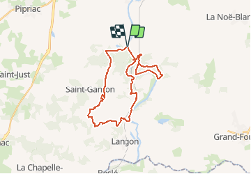
33 km | 39 km-effort
3h 0min
![](https://static1.geolcdn.com/siteimages/upload/files/16400158638029165_repeat_loop_refresh_sync_direction_icon.png)
Non
![Randonnée Marche Langon - Circuit à l'Assaut de Corbinières - Langon - Photo](https://media.geolcdn.com/t/375/260/ext.jpg?maxdim=2&url=https%3A%2F%2Fservices.sitytrail.com%2FGeolivesWS%2FDownloadMedia.ashx%3FTrailID%3D111779%26Media%3D8286_5.jpg)
![Marche Marche](https://static1.geolcdn.com/sitytour/trail-icons/101.png)
Circuit à l'Assaut de Corbinières - Langon
Marche
Difficile
Langon,
Bretagne,
Ille-et-Vilaine,
France
![](/images/other/stat-length.png)
15,6 km | 19,8 km-effort
4h 0min
![](https://static1.geolcdn.com/siteimages/upload/files/16400158638029165_repeat_loop_refresh_sync_direction_icon.png)
Oui
![Randonnée Marche Guipry-Messac - Rochers de Corbiniéres - Messac Guipry - Photo](https://media.geolcdn.com/t/375/260/ext.jpg?maxdim=2&url=https%3A%2F%2Fservices.sitytrail.com%2FGeolivesWS%2FDownloadMedia.ashx%3FTrailID%3D111684%26Media%3D7934_6.jpg)
![Marche Marche](https://static1.geolcdn.com/sitytour/trail-icons/101.png)
Rochers de Corbiniéres - Messac Guipry
Marche
Difficile
Guipry-Messac,
Bretagne,
Ille-et-Vilaine,
France
![](/images/other/stat-length.png)
13,9 km | 17,2 km-effort
3h 45min
![](https://static1.geolcdn.com/siteimages/upload/files/16400158638029165_repeat_loop_refresh_sync_direction_icon.png)
Oui
![Randonnée Marche Guipry-Messac - L'étang et le bois de Baron - Messac Guipry - Photo](https://media.geolcdn.com/t/375/260/ext.jpg?maxdim=2&url=https%3A%2F%2Fservices.sitytrail.com%2FGeolivesWS%2FDownloadMedia.ashx%3FTrailID%3D111683%26Media%3D7933_2.jpg)
![Marche Marche](https://static1.geolcdn.com/sitytour/trail-icons/101.png)
L'étang et le bois de Baron - Messac Guipry
Marche
Moyen
Guipry-Messac,
Bretagne,
Ille-et-Vilaine,
France
![](/images/other/stat-length.png)
8,5 km | 10,9 km-effort
2h 10min
![](https://static1.geolcdn.com/siteimages/upload/files/16400158638029165_repeat_loop_refresh_sync_direction_icon.png)
Oui
![Randonnée Vélo électrique Guipry-Messac - Guipry-Messac à Redon - Photo](https://media.geolcdn.com/t/375/260/ext.jpg?maxdim=2&url=https%3A%2F%2Fstatic1.geolcdn.com%2Fsiteimages%2Fupload%2Ffiles%2F1524743154velo.jpg)
![Vélo électrique Vélo électrique](https://static1.geolcdn.com/sitytour/trail-icons/205.png)
Guipry-Messac à Redon
Vélo électrique
Moyen
Guipry-Messac,
Bretagne,
Ille-et-Vilaine,
France
![](/images/other/stat-length.png)
46 km | 50 km-effort
3h 33min
![](https://static1.geolcdn.com/siteimages/upload/files/16400158638029165_repeat_loop_refresh_sync_direction_icon.png)
Non
![Randonnée Marche Guipry-Messac - vous de baron - Photo](https://media.geolcdn.com/t/375/260/1e029175-1328-4018-9b31-3921eccd22c8.jpg&format=jpg&maxdim=2)
![Marche Marche](https://static1.geolcdn.com/sitytour/trail-icons/101.png)
vous de baron
Marche
Facile
Guipry-Messac,
Bretagne,
Ille-et-Vilaine,
France
![](/images/other/stat-length.png)
9,4 km | 11,8 km-effort
2h 6min
![](https://static1.geolcdn.com/siteimages/upload/files/16400158638029165_repeat_loop_refresh_sync_direction_icon.png)
Oui
![Randonnée Marche Guipry-Messac - 14/07/2024 - Étang Baron à Corbinières - Photo](https://media.geolcdn.com/t/375/260/ext.jpg?maxdim=2&url=https%3A%2F%2Fstatic1.geolcdn.com%2Fsiteimages%2Fupload%2Ffiles%2F1553511878bg_sport_marche.png)
![Marche Marche](https://static1.geolcdn.com/sitytour/trail-icons/101.png)
14/07/2024 - Étang Baron à Corbinières
Marche
Moyen
Guipry-Messac,
Bretagne,
Ille-et-Vilaine,
France
![](/images/other/stat-length.png)
9 km | 11,5 km-effort
2h 34min
![](https://static1.geolcdn.com/siteimages/upload/files/16400158638029165_repeat_loop_refresh_sync_direction_icon.png)
Oui
![Randonnée Cyclotourisme Guipry-Messac - [BRETAGNE 2024] ET 4 - De Guipry à Saint-Nicolas de Redon - Photo](https://media.geolcdn.com/t/375/260/ext.jpg?maxdim=2&url=https%3A%2F%2Fstatic1.geolcdn.com%2Fsiteimages%2Fupload%2Ffiles%2F1524743154velo.jpg)
![Cyclotourisme Cyclotourisme](https://static1.geolcdn.com/sitytour/trail-icons/204.png)
[BRETAGNE 2024] ET 4 - De Guipry à Saint-Nicolas de Redon
Cyclotourisme
Très difficile
Guipry-Messac,
Bretagne,
Ille-et-Vilaine,
France
![](/images/other/stat-length.png)
43 km | 46 km-effort
Inconnu
![](https://static1.geolcdn.com/siteimages/upload/files/16400158638029165_repeat_loop_refresh_sync_direction_icon.png)
Non
![Randonnée A pied Sainte-Anne-sur-Vilaine - 28/08/2023 - De Port de Roche à Corbinières.Virtuel - Photo](https://media.geolcdn.com/t/375/260/ext.jpg?maxdim=2&url=https%3A%2F%2Fstatic1.geolcdn.com%2Fsiteimages%2Fupload%2Ffiles%2F1545311037marcheuse_200dpi.jpg)
![A pied A pied](https://static1.geolcdn.com/sitytour/trail-icons/100.png)
28/08/2023 - De Port de Roche à Corbinières.Virtuel
A pied
Facile
Sainte-Anne-sur-Vilaine,
Bretagne,
Ille-et-Vilaine,
France
![](/images/other/stat-length.png)
9,7 km | 11,4 km-effort
2h 35min
![](https://static1.geolcdn.com/siteimages/upload/files/16400158638029165_repeat_loop_refresh_sync_direction_icon.png)
Oui