


21 km | 25 km-effort


Utilisateur


Application GPS de randonnée GRATUITE
 SityTrail
IGN / Instituts géographiques
SityTrail World
Le monde est à vous
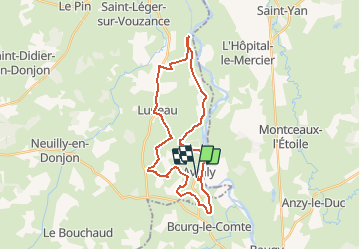
Randonnée V.T.T. de 29 km à découvrir à Auvergne-Rhône-Alpes, Allier, Avrilly. Cette randonnée est proposée par tracegps.
Parking et départ de la salle polyvalente. Éviter de se lancer sur ce parcours quand le terrain est très gras. Pour tracer cet itinéraire je me suis inspiré de 2 circuits du topoguide «Randonnées découverte en Val Libre». Autour d’Avrilly, cette boucle emprunte les contours du Circuit Au fil de l’eau et Autour de Luneau, les contours du Circuit du Chemin du Canal de Roanne. Le parcours est plutôt roulant et il comporte quelques longues liaisons sur de petites routes du réseau secondaire. Le circuit vous fera longer de nombreux étangs et quelques bois, découvrir le bocage et son doux vallonnement verdoyant avec de nombreuses fermes isolées et apercevoir les monts environnants. Topoguide : Randonnées découverte en Val Libre, 14 circuits de balades à pied, à vélo et à cheval, disponible à la Communauté de Communes Le Donjon Val Libre (adresse : 5, Le Plessis 03130 Le Donjon).


Marche
V.T.T.
V.T.T.
V.T.T.
Quad
V.T.T.
Quad
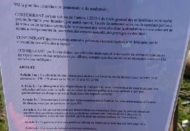
Moteur
Marche