![](/images/other/stat-length.png)
![Randonnée Cheval Guipavas - De Gupavas à la Forêt de Landerneau - Photo](https://media.geolcdn.com/t/1900/400/ext.pjpeg?maxdim=2&url=https%3A%2F%2Fservices.sitytrail.com%2FGeolivesWS%2FDownloadMedia.ashx%3FTrailID%3D317223%26Media%3D16399_2.jpg)
De Gupavas à la Forêt de Landerneau
tracegps
Utilisateur
![Longueur](/images/other/stat-length.png)
Longueur
31 km
![Altitude max](https://static1.geolcdn.com/siteimages/upload/files/1508320355ic_sort_altitude_max_24dp.png)
Altitude max
130 m
![Dénivelé positif](https://static1.geolcdn.com/siteimages/upload/files/1508320355ic_sort_den_pos_24dp.png)
Dénivelé positif
511 m
![Km-Effort](/images/other/stat-length.png)
Km-Effort
38 km
![Altitude min](https://static1.geolcdn.com/siteimages/upload/files/1508320355ic_sort_altitude_min_24dp.png)
Altitude min
0 m
![Dénivelé négatif](https://static1.geolcdn.com/siteimages/upload/files/1508320355ic_sort_den_neg_24dp.png)
Dénivelé négatif
513 m
![Boucle](https://static1.geolcdn.com/siteimages/upload/files/16400158638029165_repeat_loop_refresh_sync_direction_icon.png)
Boucle
Oui
Date de création :
2014-12-10 00:00:00.0
Dernière modification :
2014-12-10 00:00:00.0
![Cheval](https://static1.geolcdn.com/sitytour/trail-icons/300.png)
3h00
Difficulté : Moyen
![Scannez ce code QR pour ouvrir la randonnée dans l'application SityTrail](https://capi.geolives.com/qq0zvz2zws4bq2lad0pu/sitytour/trails/317223/qr.png?size=200)
Application GPS de randonnée GRATUITE
À propos
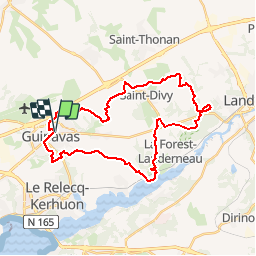
Randonnée Cheval de 31 km à découvrir à Bretagne, Finistère, Guipavas. Cette randonnée est proposée par tracegps.
Description
Circuit typé vtt enduro, comme toujours sur Ainsa, exigeant physiquement et techniquement. Il peut se faire toute l'année, toutefois attention dans les descentes en conditions humides car les dalles pierreuses peuvent être piégeuses!
Localisation
Pays :
France
Région :
Bretagne
Département/Province :
Finistère
Commune :
Guipavas
Localité :
Unknown
Départ:(Dec)
Départ:(UTM)
396631 ; 5365799 (30U) N.
Commentaires
Randonnées à proximité
![Randonnée Marche Kersaint-Plabennec - Coulée verte a Kersaint-Plabennec - Photo](https://media.geolcdn.com/t/375/260/ext.jpg?maxdim=2&url=https%3A%2F%2Fservices.sitytrail.com%2FGeolivesWS%2FDownloadMedia.ashx%3FTrailID%3D210069%26Media%3Dfix__20130804140056.jpg)
![Marche Marche](https://static1.geolcdn.com/sitytour/trail-icons/101.png)
Coulée verte a Kersaint-Plabennec
Marche
Très facile
(1)
Kersaint-Plabennec,
Bretagne,
Finistère,
France
![](/images/other/stat-length.png)
2,6 km | 2,8 km-effort
58min
![](https://static1.geolcdn.com/siteimages/upload/files/16400158638029165_repeat_loop_refresh_sync_direction_icon.png)
Oui
![Randonnée Marche Guipavas - Cotaudon - Brest - Photo](https://media.geolcdn.com/t/375/260/ext.jpg?maxdim=2&url=https%3A%2F%2Fservices.sitytrail.com%2FGeolivesWS%2FDownloadMedia.ashx%3FTrailID%3D109156%26Media%3D3199_1.jpg)
![Marche Marche](https://static1.geolcdn.com/sitytour/trail-icons/101.png)
Cotaudon - Brest
Marche
Moyen
(2)
Guipavas,
Bretagne,
Finistère,
France
![](/images/other/stat-length.png)
10,8 km | 13,2 km-effort
2h 19min
![](https://static1.geolcdn.com/siteimages/upload/files/16400158638029165_repeat_loop_refresh_sync_direction_icon.png)
Oui
![Randonnée Marche nordique Brest - géant, moulin blanc. neovan - Photo](https://media.geolcdn.com/t/375/260/ext.jpg?maxdim=2&url=https%3A%2F%2Fstatic1.geolcdn.com%2Fsiteimages%2Fupload%2Ffiles%2F1545311037marcheuse_200dpi.jpg)
![Marche nordique Marche nordique](https://static1.geolcdn.com/sitytour/trail-icons/102.png)
géant, moulin blanc. neovan
Marche nordique
Facile
(1)
Brest,
Bretagne,
Finistère,
France
![](/images/other/stat-length.png)
9,6 km | 11,7 km-effort
2h 24min
![](https://static1.geolcdn.com/siteimages/upload/files/16400158638029165_repeat_loop_refresh_sync_direction_icon.png)
Non
![Randonnée Marche Le Relecq-Kerhuon - Bois du Costour- port de plaisance - Photo](https://media.geolcdn.com/t/375/260/00dbf269-ff8c-4178-9ed9-3ed5a4b38cc9.jpg&format=jpg&maxdim=2)
![Marche Marche](https://static1.geolcdn.com/sitytour/trail-icons/101.png)
Bois du Costour- port de plaisance
Marche
Difficile
Le Relecq-Kerhuon,
Bretagne,
Finistère,
France
![](/images/other/stat-length.png)
10,6 km | 12,7 km-effort
1h 44min
![](https://static1.geolcdn.com/siteimages/upload/files/16400158638029165_repeat_loop_refresh_sync_direction_icon.png)
Oui
![Randonnée Marche Le Relecq-Kerhuon - Odyssea 2022 - Photo](https://media.geolcdn.com/t/375/260/f5b72737-5ceb-4f94-a5ae-a071ea4d99f4.jpg&format=jpg&maxdim=2)
![Marche Marche](https://static1.geolcdn.com/sitytour/trail-icons/101.png)
Odyssea 2022
Marche
Moyen
Le Relecq-Kerhuon,
Bretagne,
Finistère,
France
![](/images/other/stat-length.png)
7,1 km | 8,2 km-effort
1h 26min
![](https://static1.geolcdn.com/siteimages/upload/files/16400158638029165_repeat_loop_refresh_sync_direction_icon.png)
Oui
![Randonnée Marche Guipavas - Kerhuon-Guipavas-Brest entre mer et forêts - Photo](https://media.geolcdn.com/t/375/260/af9d9627-8d8a-48fe-bed5-cb442ad0d666.jpg&format=jpg&maxdim=2)
![Marche Marche](https://static1.geolcdn.com/sitytour/trail-icons/101.png)
Kerhuon-Guipavas-Brest entre mer et forêts
Marche
Très difficile
Guipavas,
Bretagne,
Finistère,
France
![](/images/other/stat-length.png)
24 km | 30 km-effort
4h 1min
![](https://static1.geolcdn.com/siteimages/upload/files/16400158638029165_repeat_loop_refresh_sync_direction_icon.png)
Non
![Randonnée Marche nordique Guipavas - hôtel cafe chantant st divi guipavas - Photo](https://media.geolcdn.com/t/375/260/1880b21b-949a-4788-b275-62329c398c0c.jpg&format=jpg&maxdim=2)
![Marche nordique Marche nordique](https://static1.geolcdn.com/sitytour/trail-icons/102.png)
hôtel cafe chantant st divi guipavas
Marche nordique
Très facile
Guipavas,
Bretagne,
Finistère,
France
![](/images/other/stat-length.png)
13 km | 15,1 km-effort
3h 14min
![](https://static1.geolcdn.com/siteimages/upload/files/16400158638029165_repeat_loop_refresh_sync_direction_icon.png)
Oui
![Randonnée Marche Brest - Stangalard-Costour - Photo](https://media.geolcdn.com/t/375/260/ext.jpg?maxdim=2&url=https%3A%2F%2Fservices.sitytrail.com%2FGeolivesWS%2FDownloadMedia.ashx%3FTrailID%3D1125537%26Media%3Dfix__20190323111003.jpg)
![Marche Marche](https://static1.geolcdn.com/sitytour/trail-icons/101.png)
Stangalard-Costour
Marche
Facile
Brest,
Bretagne,
Finistère,
France
![](/images/other/stat-length.png)
7,6 km | 8,8 km-effort
1h 43min
![](https://static1.geolcdn.com/siteimages/upload/files/16400158638029165_repeat_loop_refresh_sync_direction_icon.png)
Oui
![Randonnée Marche Guipavas - PR Tour du Douvez Guipavas - Photo](https://media.geolcdn.com/t/375/260/ext.jpg?maxdim=2&url=https%3A%2F%2Fservices.sitytrail.com%2FGeolivesWS%2FDownloadMedia.ashx%3FTrailID%3D882174%26Media%3Dfix__20180101151203.jpg)
![Marche Marche](https://static1.geolcdn.com/sitytour/trail-icons/101.png)
PR Tour du Douvez Guipavas
Marche
Facile
Guipavas,
Bretagne,
Finistère,
France
![](/images/other/stat-length.png)
10,5 km | 12,6 km-effort
2h 44min
![](https://static1.geolcdn.com/siteimages/upload/files/16400158638029165_repeat_loop_refresh_sync_direction_icon.png)
Oui