![](/images/other/stat-length.png)
![Randonnée V.T.T. Arc-et-Senans - Croix de Mesmay par Rennes sur Loue - Photo](https://media.geolcdn.com/t/1900/400/ext.pjpeg?maxdim=2&url=https%3A%2F%2Fservices.sitytrail.com%2FGeolivesWS%2FDownloadMedia.ashx%3FTrailID%3D317204%26Media%3D16373_2.jpg)
Croix de Mesmay par Rennes sur Loue
tracegps
Utilisateur
![Longueur](/images/other/stat-length.png)
![Altitude max](https://static1.geolcdn.com/siteimages/upload/files/1508320355ic_sort_altitude_max_24dp.png)
![Dénivelé positif](https://static1.geolcdn.com/siteimages/upload/files/1508320355ic_sort_den_pos_24dp.png)
![Km-Effort](/images/other/stat-length.png)
![Altitude min](https://static1.geolcdn.com/siteimages/upload/files/1508320355ic_sort_altitude_min_24dp.png)
![Dénivelé négatif](https://static1.geolcdn.com/siteimages/upload/files/1508320355ic_sort_den_neg_24dp.png)
![Boucle](https://static1.geolcdn.com/siteimages/upload/files/16400158638029165_repeat_loop_refresh_sync_direction_icon.png)
![V.T.T.](https://static1.geolcdn.com/sitytour/trail-icons/202.png)
2h00
Difficulté : Moyen
![Scannez ce code QR pour ouvrir la randonnée dans l'application SityTrail](https://capi.geolives.com/qq0zvz2zws4bq2lad0pu/sitytour/trails/317204/qr.png?size=200)
Application GPS de randonnée GRATUITE
À propos
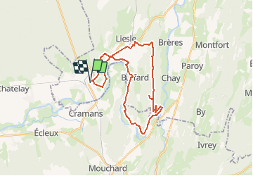
Randonnée V.T.T. de 30 km à découvrir à Bourgogne-Franche-Comté, Doubs, Arc-et-Senans. Cette randonnée est proposée par tracegps.
Description
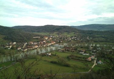
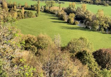
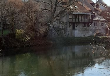
Parcours permettant de cheminer le long de la Loue dans sa première partie, de gravir la colline entre Rennes-Sur-Loue et Mesmay, avant d'entamer le retour par Liesle et le bois de la Pérouse. Dans un premier temps le circuit est plat et roulant (petite route, chemin blanc, sentier roulant), puis il devient pentu et plus difficile avec une montée sur chemin empierré raviné. Arrivé au point culminant, une petite sortie du parcours initial permet de découvrir un oratoire perdu au milieu des bois. Après avoir repris le cheminement initial, le pilotage deviendra plus technique si le terrain est humide, ce qui est souvent le cas, puisque le sentier est sous les buis. La prudence sera de mise et le dégonflage des pneus peut-être nécessaire si le terrain est détrempé. Après un long cheminement jusqu'à la Croix de Mesmay (croix en granit !) la descente sur Liesle demandera un peu de vigilance. La suite du circuit permet un retour "aisé" jusqu'au point de départ.
Localisation
Commentaires
Randonnées à proximité
![Randonnée A pied Chissey-sur-Loue - VTToutrail - Photo](https://media.geolcdn.com/t/375/260/00ee013d-9a44-4a24-8b71-4e7efa590a4c.jpeg&format=jpg&maxdim=2)
![A pied A pied](https://static1.geolcdn.com/sitytour/trail-icons/100.png)
A pied
![](/images/other/stat-length.png)
![](https://static1.geolcdn.com/siteimages/upload/files/16400158638029165_repeat_loop_refresh_sync_direction_icon.png)
![Randonnée A pied Port-Lesney - Val d'Amour - Photo](https://media.geolcdn.com/t/375/260/5cfc7e14-9f65-4fa1-a053-b82c7404ed99.jpeg&format=jpg&maxdim=2)
![A pied A pied](https://static1.geolcdn.com/sitytour/trail-icons/100.png)
A pied
![](/images/other/stat-length.png)
![](https://static1.geolcdn.com/siteimages/upload/files/16400158638029165_repeat_loop_refresh_sync_direction_icon.png)
![Randonnée A pied Villers-Farlay - Four tuilier - Photo](https://media.geolcdn.com/t/375/260/82a10c26-9ed7-4536-8432-445535097e12.jpeg&format=jpg&maxdim=2)
![A pied A pied](https://static1.geolcdn.com/sitytour/trail-icons/100.png)
A pied
![](/images/other/stat-length.png)
![](https://static1.geolcdn.com/siteimages/upload/files/16400158638029165_repeat_loop_refresh_sync_direction_icon.png)
![Randonnée A pied Port-Lesney - Chemin des Gabelous - Photo](https://media.geolcdn.com/t/375/260/09807b3d-6dc5-4f94-a372-f894abc0bac2.jpeg&format=jpg&maxdim=2)
![A pied A pied](https://static1.geolcdn.com/sitytour/trail-icons/100.png)
A pied
![](/images/other/stat-length.png)
![](https://static1.geolcdn.com/siteimages/upload/files/16400158638029165_repeat_loop_refresh_sync_direction_icon.png)
![Randonnée Marche Cramans - Cramans Mochard 2021-02-04 CAF - Photo](https://media.geolcdn.com/t/375/260/42121a58-6316-4979-99db-48595569155b.jpg&format=jpg&maxdim=2)
![Marche Marche](https://static1.geolcdn.com/sitytour/trail-icons/101.png)
Marche
![](/images/other/stat-length.png)
![](https://static1.geolcdn.com/siteimages/upload/files/16400158638029165_repeat_loop_refresh_sync_direction_icon.png)
![Randonnée V.T.T. Arc-et-Senans - Les Baraques du 14 depuis la Saline Royale d'Arc-et-Senans - Photo](https://media.geolcdn.com/t/375/260/ext.jpg?maxdim=2&url=https%3A%2F%2Fservices.sitytrail.com%2FGeolivesWS%2FDownloadMedia.ashx%3FTrailID%3D317255%26Media%3D16439_4.jpg)
![V.T.T. V.T.T.](https://static1.geolcdn.com/sitytour/trail-icons/202.png)
V.T.T.
![](/images/other/stat-length.png)
![](https://static1.geolcdn.com/siteimages/upload/files/16400158638029165_repeat_loop_refresh_sync_direction_icon.png)
![Randonnée Marche Champagne-sur-Loue - champagne sur Loue - Photo](https://media.geolcdn.com/t/375/260/dd8d5849-8e09-4521-8614-bfddc1d7c7ae.jpg&format=jpg&maxdim=2)
![Marche Marche](https://static1.geolcdn.com/sitytour/trail-icons/101.png)
Marche
![](/images/other/stat-length.png)
![](https://static1.geolcdn.com/siteimages/upload/files/16400158638029165_repeat_loop_refresh_sync_direction_icon.png)
![Randonnée Marche Port-Lesney - Vaulgrenan depuis Port Lesney. - Photo](https://media.geolcdn.com/t/375/260/888b9e37-2427-47c6-a53b-dfa1373cf9fa.jpg&format=jpg&maxdim=2)
![Marche Marche](https://static1.geolcdn.com/sitytour/trail-icons/101.png)
Marche
![](/images/other/stat-length.png)
![](https://static1.geolcdn.com/siteimages/upload/files/16400158638029165_repeat_loop_refresh_sync_direction_icon.png)
![Randonnée Marche Arc-et-Senans - Arc et Senans - Photo](https://media.geolcdn.com/t/375/260/2334323b-d438-4b84-9e9e-ba5bf6e226d2.jpg&format=jpg&maxdim=2)
![Marche Marche](https://static1.geolcdn.com/sitytour/trail-icons/101.png)
Marche
![](/images/other/stat-length.png)
![](https://static1.geolcdn.com/siteimages/upload/files/16400158638029165_repeat_loop_refresh_sync_direction_icon.png)
Ballade roulante et sans grand intérêt. Erreur en haut de la côté, le chemin pars à droite et reviens... Aucun intérêt. La dernière partie est non balisée et pas nettoyée.