![](/images/other/stat-length.png)
![Randonnée Marche Courgoul - Le tour du pic de Cluzel - Courgoul - Photo](https://media.geolcdn.com/t/1900/400/ext.pjpeg?maxdim=2&url=https%3A%2F%2Fservices.sitytrail.com%2FGeolivesWS%2FDownloadMedia.ashx%3FTrailID%3D317160%26Media%3D16311_2.jpg)
Le tour du pic de Cluzel - Courgoul
tracegps
Utilisateur
![Longueur](/images/other/stat-length.png)
![Altitude max](https://static1.geolcdn.com/siteimages/upload/files/1508320355ic_sort_altitude_max_24dp.png)
![Dénivelé positif](https://static1.geolcdn.com/siteimages/upload/files/1508320355ic_sort_den_pos_24dp.png)
![Km-Effort](/images/other/stat-length.png)
![Altitude min](https://static1.geolcdn.com/siteimages/upload/files/1508320355ic_sort_altitude_min_24dp.png)
![Dénivelé négatif](https://static1.geolcdn.com/siteimages/upload/files/1508320355ic_sort_den_neg_24dp.png)
![Boucle](https://static1.geolcdn.com/siteimages/upload/files/16400158638029165_repeat_loop_refresh_sync_direction_icon.png)
![Marche](https://static1.geolcdn.com/sitytour/trail-icons/101.png)
3h30
Difficulté : Moyen
![Scannez ce code QR pour ouvrir la randonnée dans l'application SityTrail](https://capi.geolives.com/qq0zvz2zws4bq2lad0pu/sitytour/trails/317160/qr.png?size=200)
Application GPS de randonnée GRATUITE
À propos
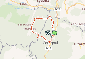
Randonnée Marche de 5,6 km à découvrir à Auvergne-Rhône-Alpes, Puy-de-Dôme, Courgoul. Cette randonnée est proposée par tracegps.
Description
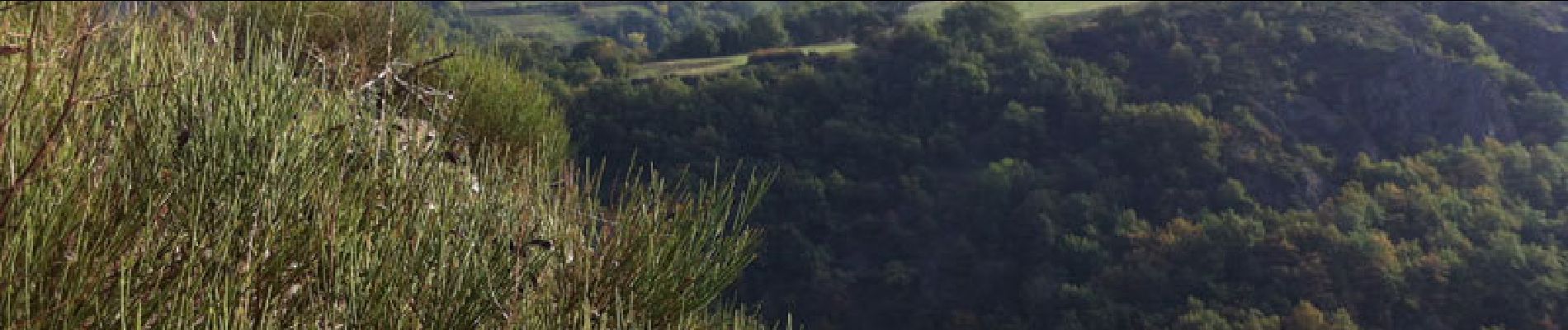
Le tour du pic de Cluzel s'effectue sur un petit sentier s'élevant doucement, épousant les flancs du pic boisés de chênes rabougris. Une végétation qui vers l'Est est presque méditerranéenne. Les vues sur la vallée sont nombreuses. Sur le premier tiers du parcours, deux anciens fours de carbonisation du bois datant des années 1940-1943 rappellent une histoire parfois ignorée des plus jeunes... Une partie presque hors piste, seulement empruntée par les animaux rejoint très aisément un chemin cadastré au dessus que l'on emprunte en descendant vers Pradelle. Le retour à Courgoul emprunte sur tout le reste du parcours un large chemin passant au col à la cote 812. Un bel itinéraire à faire par tout temps.
Localisation
Commentaires
Randonnées à proximité
![Randonnée A pied Dauzat-sur-Vodable - Dauzat-sur-Vodable - Photo](https://media.geolcdn.com/t/375/260/d172e481-65da-4881-bd03-f6cc99def315.jpeg&format=jpg&maxdim=2)
![A pied A pied](https://static1.geolcdn.com/sitytour/trail-icons/100.png)
A pied
![](/images/other/stat-length.png)
![](https://static1.geolcdn.com/siteimages/upload/files/16400158638029165_repeat_loop_refresh_sync_direction_icon.png)
![Randonnée A pied Saint-Diéry - Le Cheix - Photo](https://media.geolcdn.com/t/375/260/cef373ab-41f4-493d-8694-97c838874352.jpeg&format=jpg&maxdim=2)
![A pied A pied](https://static1.geolcdn.com/sitytour/trail-icons/100.png)
A pied
![](/images/other/stat-length.png)
![](https://static1.geolcdn.com/siteimages/upload/files/16400158638029165_repeat_loop_refresh_sync_direction_icon.png)
![Randonnée A pied Saint-Floret - Clemensat - Photo](https://media.geolcdn.com/t/375/260/768fec42-41d9-4005-9393-314a0342ff62.jpeg&format=jpg&maxdim=2)
![A pied A pied](https://static1.geolcdn.com/sitytour/trail-icons/100.png)
A pied
![](/images/other/stat-length.png)
![](https://static1.geolcdn.com/siteimages/upload/files/16400158638029165_repeat_loop_refresh_sync_direction_icon.png)
![Randonnée A pied Valbeleix - Le Plateau de la Chavade et la Roche Nite - Photo](https://media.geolcdn.com/t/375/260/a467407f-a0fb-4883-8852-b6255f6151df.jpeg&format=jpg&maxdim=2)
![A pied A pied](https://static1.geolcdn.com/sitytour/trail-icons/100.png)
A pied
![](/images/other/stat-length.png)
![](https://static1.geolcdn.com/siteimages/upload/files/16400158638029165_repeat_loop_refresh_sync_direction_icon.png)
![Randonnée A pied Saurier - Le Pic de Brionnet - Photo](https://media.geolcdn.com/t/375/260/6e33ab27-c788-4f32-8c30-5bc1de6dd66f.jpeg&format=jpg&maxdim=2)
![A pied A pied](https://static1.geolcdn.com/sitytour/trail-icons/100.png)
A pied
![](/images/other/stat-length.png)
![](https://static1.geolcdn.com/siteimages/upload/files/16400158638029165_repeat_loop_refresh_sync_direction_icon.png)
![Randonnée Marche Courgoul - Les-Gorges-de-Courgoul-Marcenat_T - Photo](https://media.geolcdn.com/t/375/260/78d4684c-2220-458c-aac4-f2b1ac8cba79.jpg&format=jpg&maxdim=2)
![Marche Marche](https://static1.geolcdn.com/sitytour/trail-icons/101.png)
Marche
![](/images/other/stat-length.png)
![](https://static1.geolcdn.com/siteimages/upload/files/16400158638029165_repeat_loop_refresh_sync_direction_icon.png)
![Randonnée Marche Saint-Diéry - St_Diery_Mont_Carmel - Photo](https://media.geolcdn.com/t/375/260/3e3b4de8-74a3-4fde-8693-784ab1979488.jpg&format=jpg&maxdim=2)
![Marche Marche](https://static1.geolcdn.com/sitytour/trail-icons/101.png)
Marche
![](/images/other/stat-length.png)
![](https://static1.geolcdn.com/siteimages/upload/files/16400158638029165_repeat_loop_refresh_sync_direction_icon.png)
![Randonnée A pied Saint-Diéry - Cotteuge - Photo](https://media.geolcdn.com/t/375/260/cef373ab-41f4-493d-8694-97c838874352.jpeg&format=jpg&maxdim=2)
![A pied A pied](https://static1.geolcdn.com/sitytour/trail-icons/100.png)
A pied
![](/images/other/stat-length.png)
![](https://static1.geolcdn.com/siteimages/upload/files/16400158638029165_repeat_loop_refresh_sync_direction_icon.png)
![Randonnée A pied Chassagne - Le Plateau d'Ussel - Photo](https://media.geolcdn.com/t/375/260/56405ee6-4d93-4498-a458-c552d564104f.jpeg&format=jpg&maxdim=2)
![A pied A pied](https://static1.geolcdn.com/sitytour/trail-icons/100.png)
A pied
![](/images/other/stat-length.png)
![](https://static1.geolcdn.com/siteimages/upload/files/16400158638029165_repeat_loop_refresh_sync_direction_icon.png)