![](/images/other/stat-length.png)
![Randonnée Marche Saint-Jean-Saint-Maurice-sur-Loire - La Croix des prés - Photo](https://media.geolcdn.com/t/1900/400/ext.pjpeg?maxdim=2&url=https%3A%2F%2Fstatic1.geolcdn.com%2Fsiteimages%2Fupload%2Ffiles%2F1553511878bg_sport_marche.png)
La Croix des prés
jpc42
Utilisateur
![Longueur](/images/other/stat-length.png)
![Altitude max](https://static1.geolcdn.com/siteimages/upload/files/1508320355ic_sort_altitude_max_24dp.png)
![Dénivelé positif](https://static1.geolcdn.com/siteimages/upload/files/1508320355ic_sort_den_pos_24dp.png)
![Km-Effort](/images/other/stat-length.png)
![Altitude min](https://static1.geolcdn.com/siteimages/upload/files/1508320355ic_sort_altitude_min_24dp.png)
![Dénivelé négatif](https://static1.geolcdn.com/siteimages/upload/files/1508320355ic_sort_den_neg_24dp.png)
![Boucle](https://static1.geolcdn.com/siteimages/upload/files/16400158638029165_repeat_loop_refresh_sync_direction_icon.png)
![Marche](https://static1.geolcdn.com/sitytour/trail-icons/101.png)
5h00
Difficulté : Difficile
![Scannez ce code QR pour ouvrir la randonnée dans l'application SityTrail](https://capi.geolives.com/qq0zvz2zws4bq2lad0pu/sitytour/trails/3171129/qr.png?size=200)
Application GPS de randonnée GRATUITE
À propos
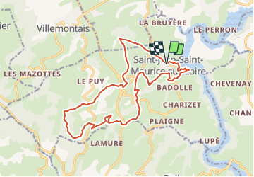
Randonnée Marche de 18,3 km à découvrir à Auvergne-Rhône-Alpes, Loire, Saint-Jean-Saint-Maurice-sur-Loire. Cette randonnée est proposée par jpc42.
Description
Circuit Roanne agglo n°9
Départ St Jean St Maurice parking de la Mairie.
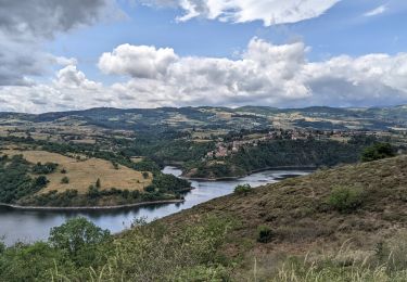
Un parcours sportif qui vous mènera des gorges de la Loire aux Monts de la Madeleine à travers les coteaux viticoles...
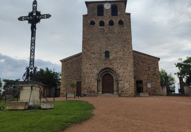
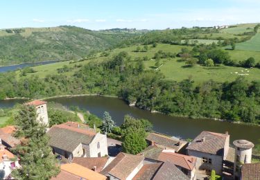
Ce village de caractère est organisé autour de deux centres de vie. Le village de St-Maurice à caractère médiéval, niché sur un promontoire dominant la Loire et le village de St-Jean occupant un territoire moins escarpé. L’église de St-Maurice possède un choeur couvert de fresques du XIIIème.
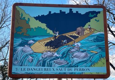
Dans l’embrasure d’une fenêtre, une fresque de St-Jacques atteste que St-Maurice était sur le chemin de Compostelle.
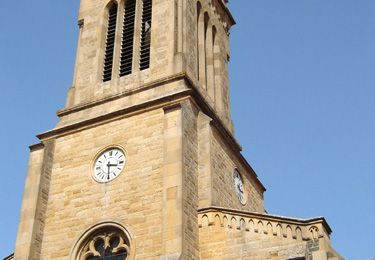
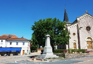
L’église de St-Jean, reconstruite vers 1870, est dominée par un clocher porche du XIIème seul témoin du prieuré bénédictin auquel elle appartenait et qui a été démantelé à la Révolution.
Au XVIème sont bâtis le manoir du Cadran Solaire et celui de « La Mure ».
Localisation
Commentaires
Randonnées à proximité
![Randonnée Marche Saint-Jean-Saint-Maurice-sur-Loire - Autour des Gorges de la Loire - PR N° 9 : Sur le pas des pèlerins - Saint-Jean-Saint-Maurice-sur-Loire - Photo](https://media.geolcdn.com/t/375/260/ext.jpg?maxdim=2&url=https%3A%2F%2Fservices.sitytrail.com%2FGeolivesWS%2FDownloadMedia.ashx%3FTrailID%3D215167%26Media%3D15769_6.jpg)
![Marche Marche](https://static1.geolcdn.com/sitytour/trail-icons/101.png)
Marche
![](/images/other/stat-length.png)
![](https://static1.geolcdn.com/siteimages/upload/files/16400158638029165_repeat_loop_refresh_sync_direction_icon.png)
![Randonnée Marche Saint-Jean-Saint-Maurice-sur-Loire - Saint -Jean Saint -Maurice sur Loire - Photo](https://media.geolcdn.com/t/375/260/1053c594-4557-4a01-9659-5504d28a00d0.jpg&format=jpg&maxdim=2)
![Marche Marche](https://static1.geolcdn.com/sitytour/trail-icons/101.png)
Marche
![](/images/other/stat-length.png)
![](https://static1.geolcdn.com/siteimages/upload/files/16400158638029165_repeat_loop_refresh_sync_direction_icon.png)
![Randonnée sport Saint-Jean-Saint-Maurice-sur-Loire - Retour bis - Photo](https://media.geolcdn.com/t/375/260/ext.jpg?maxdim=2&url=https%3A%2F%2Fsecurestorage.geolives.com%2Fsitytour%2Ftrail-bg%2Fdefault.jpg)
sport
![](/images/other/stat-length.png)
![](https://static1.geolcdn.com/siteimages/upload/files/16400158638029165_repeat_loop_refresh_sync_direction_icon.png)
![Randonnée Marche Cordelle - boucle rilly-9.7 km - Photo](https://media.geolcdn.com/t/375/260/70cbec56-e75d-4971-a31c-1db03be10e15.jpg&format=jpg&maxdim=2)
![Marche Marche](https://static1.geolcdn.com/sitytour/trail-icons/101.png)
Marche
![](/images/other/stat-length.png)
![](https://static1.geolcdn.com/siteimages/upload/files/16400158638029165_repeat_loop_refresh_sync_direction_icon.png)
![Randonnée Marche Villemontais - Villemontais : Chérier et Haut Ste-Agathe - Photo](https://media.geolcdn.com/t/375/260/43288f42-5353-465e-b07f-32492fc85c11.jpg&format=jpg&maxdim=2)
![Marche Marche](https://static1.geolcdn.com/sitytour/trail-icons/101.png)
Marche
![](/images/other/stat-length.png)
![](https://static1.geolcdn.com/siteimages/upload/files/16400158638029165_repeat_loop_refresh_sync_direction_icon.png)
![Randonnée Marche Cordelle - Cordelle : Terrenoire et versant sud - Photo](https://media.geolcdn.com/t/375/260/dfd1ec12-e45d-43ae-9a56-cd1f4a318fa5.jpg&format=jpg&maxdim=2)
![Marche Marche](https://static1.geolcdn.com/sitytour/trail-icons/101.png)
Marche
![](/images/other/stat-length.png)
![](https://static1.geolcdn.com/siteimages/upload/files/16400158638029165_repeat_loop_refresh_sync_direction_icon.png)
![Randonnée A pied Commelle-Vernay - Commelle-Vernay : petit train touristique - Photo](https://media.geolcdn.com/t/375/260/25e5a88d-0a40-4783-a608-61f5fa58e2c4.jpg&format=jpg&maxdim=2)
![A pied A pied](https://static1.geolcdn.com/sitytour/trail-icons/100.png)
A pied
![](/images/other/stat-length.png)
![](https://static1.geolcdn.com/siteimages/upload/files/16400158638029165_repeat_loop_refresh_sync_direction_icon.png)
![Randonnée Marche Saint-Jean-Saint-Maurice-sur-Loire - St Jean-St Maurice 18km - Photo](https://media.geolcdn.com/t/375/260/930956ea-3504-4ab8-b415-5247c26b90ff.jpg&format=jpg&maxdim=2)
![Marche Marche](https://static1.geolcdn.com/sitytour/trail-icons/101.png)
Marche
![](/images/other/stat-length.png)
![](https://static1.geolcdn.com/siteimages/upload/files/16400158638029165_repeat_loop_refresh_sync_direction_icon.png)
![Randonnée V.T.T. Lentigny - Escapade dans les Gouttes de la Loire - Lentigny - Photo](https://media.geolcdn.com/t/375/260/ext.jpg?maxdim=2&url=https%3A%2F%2Fservices.sitytrail.com%2FGeolivesWS%2FDownloadMedia.ashx%3FTrailID%3D318105%26Media%3D17564_6.jpg)
![V.T.T. V.T.T.](https://static1.geolcdn.com/sitytour/trail-icons/202.png)
V.T.T.
![](/images/other/stat-length.png)
![](https://static1.geolcdn.com/siteimages/upload/files/16400158638029165_repeat_loop_refresh_sync_direction_icon.png)