![](/images/other/stat-length.png)
![Randonnée Marche Cubjac-Auvézère-Val d'Ans - Les 4 paroisses - Cubjac - Photo](https://media.geolcdn.com/t/1900/400/ext.pjpeg?maxdim=2&url=https%3A%2F%2Fservices.sitytrail.com%2FGeolivesWS%2FDownloadMedia.ashx%3FTrailID%3D317011%26Media%3D16152_2.jpg)
Les 4 paroisses - Cubjac
tracegps
Utilisateur
![Longueur](/images/other/stat-length.png)
Longueur
12,5 km
![Altitude max](https://static1.geolcdn.com/siteimages/upload/files/1508320355ic_sort_altitude_max_24dp.png)
Altitude max
255 m
![Dénivelé positif](https://static1.geolcdn.com/siteimages/upload/files/1508320355ic_sort_den_pos_24dp.png)
Dénivelé positif
299 m
![Km-Effort](/images/other/stat-length.png)
Km-Effort
16,5 km
![Altitude min](https://static1.geolcdn.com/siteimages/upload/files/1508320355ic_sort_altitude_min_24dp.png)
Altitude min
115 m
![Dénivelé négatif](https://static1.geolcdn.com/siteimages/upload/files/1508320355ic_sort_den_neg_24dp.png)
Dénivelé négatif
300 m
![Boucle](https://static1.geolcdn.com/siteimages/upload/files/16400158638029165_repeat_loop_refresh_sync_direction_icon.png)
Boucle
Oui
Date de création :
2014-12-10 00:00:00.0
Dernière modification :
2014-12-10 00:00:00.0
![Marche](https://static1.geolcdn.com/sitytour/trail-icons/101.png)
3h00
Difficulté : Moyen
![Scannez ce code QR pour ouvrir la randonnée dans l'application SityTrail](https://capi.geolives.com/qq0zvz2zws4bq2lad0pu/sitytour/trails/317011/qr.png?size=200)
Application GPS de randonnée GRATUITE
À propos
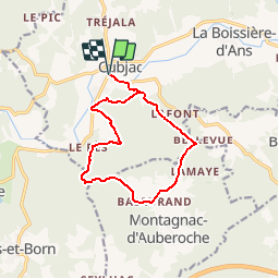
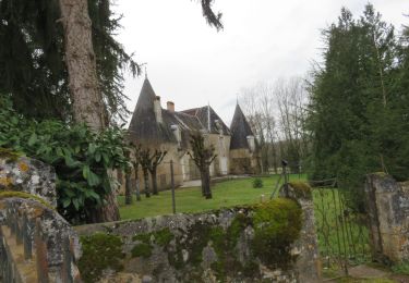
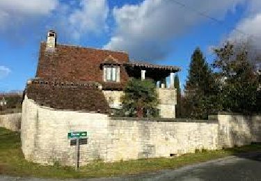
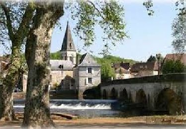
Randonnée Marche de 12,5 km à découvrir à Nouvelle-Aquitaine, Dordogne, Cubjac-Auvézère-Val d'Ans. Cette randonnée est proposée par tracegps.
Description
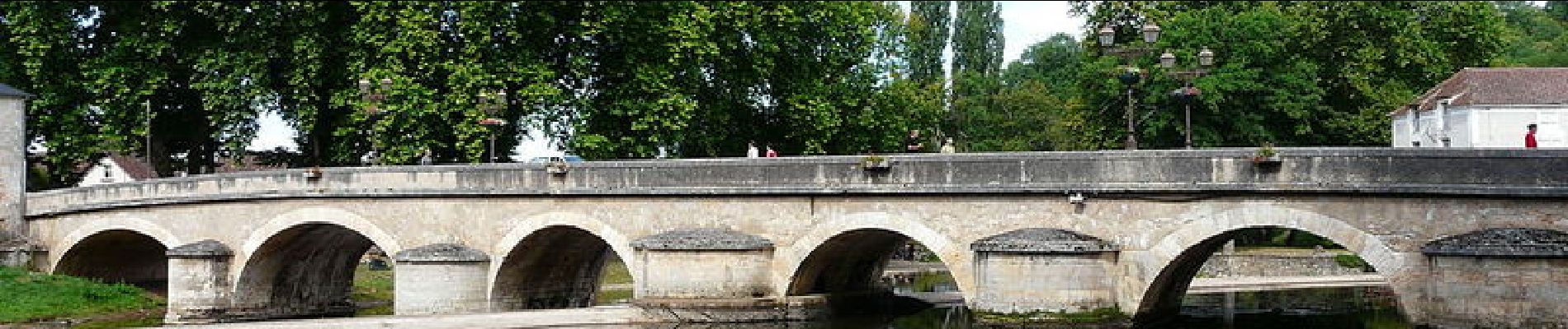
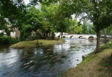
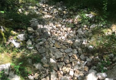
Rando variée et agréable, bien balisée, praticable en tout temps, très peu de route. Départ du pont sur l'Auvézère à Cubjac.
Localisation
Pays :
France
Région :
Nouvelle-Aquitaine
Département/Province :
Dordogne
Commune :
Cubjac-Auvézère-Val d'Ans
Localité :
Cubjac
Départ:(Dec)
Départ:(UTM)
338031 ; 5009540 (31T) N.
Commentaires
Randonnées à proximité
![Randonnée Marche Bassillac et Auberoche - Le Change Roc 9km - Photo](https://media.geolcdn.com/t/375/260/ext.jpg?maxdim=2&url=https%3A%2F%2Fstatic1.geolcdn.com%2Fsiteimages%2Fupload%2Ffiles%2F1553511878bg_sport_marche.png)
![Marche Marche](https://static1.geolcdn.com/sitytour/trail-icons/101.png)
Le Change Roc 9km
Marche
Très facile
(1)
Bassillac et Auberoche,
Nouvelle-Aquitaine,
Dordogne,
France
![](/images/other/stat-length.png)
9,3 km | 12,2 km-effort
2h 43min
![](https://static1.geolcdn.com/siteimages/upload/files/16400158638029165_repeat_loop_refresh_sync_direction_icon.png)
Oui
![Randonnée Marche Bassillac et Auberoche - Le Change Pommiers 9km - Photo](https://media.geolcdn.com/t/375/260/ext.jpg?maxdim=2&url=https%3A%2F%2Fstatic1.geolcdn.com%2Fsiteimages%2Fupload%2Ffiles%2F1553511878bg_sport_marche.png)
![Marche Marche](https://static1.geolcdn.com/sitytour/trail-icons/101.png)
Le Change Pommiers 9km
Marche
Facile
(1)
Bassillac et Auberoche,
Nouvelle-Aquitaine,
Dordogne,
France
![](/images/other/stat-length.png)
9 km | 11,3 km-effort
2h 32min
![](https://static1.geolcdn.com/siteimages/upload/files/16400158638029165_repeat_loop_refresh_sync_direction_icon.png)
Oui
![Randonnée A pied Bassillac et Auberoche - Les chabannes - Photo](https://media.geolcdn.com/t/375/260/ext.jpg?maxdim=2&url=https%3A%2F%2Fmedia.geolcdn.com%2Ff%2Fa8aade46-e147-4b35-b4a7-c1d555488ef4.jpg)
![A pied A pied](https://static1.geolcdn.com/sitytour/trail-icons/100.png)
Les chabannes
A pied
Facile
Bassillac et Auberoche,
Nouvelle-Aquitaine,
Dordogne,
France
![](/images/other/stat-length.png)
6,3 km | 8,2 km-effort
1h 52min
![](https://static1.geolcdn.com/siteimages/upload/files/16400158638029165_repeat_loop_refresh_sync_direction_icon.png)
Oui
![Randonnée Marche Cubjac-Auvézère-Val d'Ans - Le chemin du Causse - Cubjac - Photo](https://media.geolcdn.com/t/375/260/ext.jpg?maxdim=2&url=https%3A%2F%2Fservices.sitytrail.com%2FGeolivesWS%2FDownloadMedia.ashx%3FTrailID%3D111446%26Media%3D7295_3.jpg)
![Marche Marche](https://static1.geolcdn.com/sitytour/trail-icons/101.png)
Le chemin du Causse - Cubjac
Marche
Moyen
Cubjac-Auvézère-Val d'Ans,
Nouvelle-Aquitaine,
Dordogne,
France
![](/images/other/stat-length.png)
7,9 km | 10 km-effort
2h 0min
![](https://static1.geolcdn.com/siteimages/upload/files/16400158638029165_repeat_loop_refresh_sync_direction_icon.png)
Oui
![Randonnée Marche Cubjac-Auvézère-Val d'Ans - Cubjac - Photo](https://media.geolcdn.com/t/375/260/ext.jpg?maxdim=2&url=https%3A%2F%2Fmedia.geolcdn.com%2Ff%2F95906e7d-be53-4c4e-b251-9aa7f2a1ea2d.JPG)
![Marche Marche](https://static1.geolcdn.com/sitytour/trail-icons/101.png)
Cubjac
Marche
Très difficile
Cubjac-Auvézère-Val d'Ans,
Nouvelle-Aquitaine,
Dordogne,
France
![](/images/other/stat-length.png)
15,4 km | 19,7 km-effort
4h 28min
![](https://static1.geolcdn.com/siteimages/upload/files/16400158638029165_repeat_loop_refresh_sync_direction_icon.png)
Oui
![Randonnée Marche nordique Saint-Vincent-sur-l'Isle - Saint Vincent sur l'Isle MN - Photo](https://media.geolcdn.com/t/375/260/ext.jpg?maxdim=2&url=https%3A%2F%2Fmedia.geolcdn.com%2Ff%2Fe2b39c52-2522-47fc-9680-cd801e16f5c3.jpg)
![Marche nordique Marche nordique](https://static1.geolcdn.com/sitytour/trail-icons/102.png)
Saint Vincent sur l'Isle MN
Marche nordique
Moyen
Saint-Vincent-sur-l'Isle,
Nouvelle-Aquitaine,
Dordogne,
France
![](/images/other/stat-length.png)
10,3 km | 12,6 km-effort
Inconnu
![](https://static1.geolcdn.com/siteimages/upload/files/16400158638029165_repeat_loop_refresh_sync_direction_icon.png)
Oui
![Randonnée Marche Montagnac-d'Auberoche - Boucle de la fontaine Marceau ( Montagnac d’ Auberoche) - Photo](https://media.geolcdn.com/t/375/260/ext.jpg?maxdim=2&url=https%3A%2F%2Fmedia.geolcdn.com%2Ff%2Fdcf764e8-3947-4f29-9e0e-bbb82c8d0a4a.jpg)
![Marche Marche](https://static1.geolcdn.com/sitytour/trail-icons/101.png)
Boucle de la fontaine Marceau ( Montagnac d’ Auberoche)
Marche
Facile
Montagnac-d'Auberoche,
Nouvelle-Aquitaine,
Dordogne,
France
![](/images/other/stat-length.png)
6,9 km | 8,6 km-effort
2h 9min
![](https://static1.geolcdn.com/siteimages/upload/files/16400158638029165_repeat_loop_refresh_sync_direction_icon.png)
Oui
![Randonnée Marche Cubjac-Auvézère-Val d'Ans - Boucle des Quatre Paroisses - Photo](https://media.geolcdn.com/t/375/260/ext.jpg?maxdim=2&url=https%3A%2F%2Fmedia.geolcdn.com%2Ff%2F760938ba-4fea-4056-a763-6c0429a09af1.jpg)
![Marche Marche](https://static1.geolcdn.com/sitytour/trail-icons/101.png)
Boucle des Quatre Paroisses
Marche
Difficile
Cubjac-Auvézère-Val d'Ans,
Nouvelle-Aquitaine,
Dordogne,
France
![](/images/other/stat-length.png)
12,3 km | 15,9 km-effort
3h 36min
![](https://static1.geolcdn.com/siteimages/upload/files/16400158638029165_repeat_loop_refresh_sync_direction_icon.png)
Oui