![](/images/other/stat-length.png)
![Randonnée V.T.T. Marmande - De Marmande à Saint Pardoux du Breuil - Photo](https://media.geolcdn.com/t/1900/400/ext.pjpeg?maxdim=2&url=https%3A%2F%2Fservices.sitytrail.com%2FGeolivesWS%2FDownloadMedia.ashx%3FTrailID%3D316981%26Media%3D16105_2.jpg)
De Marmande à Saint Pardoux du Breuil
tracegps
Utilisateur
![Longueur](/images/other/stat-length.png)
Longueur
13,8 km
![Altitude max](https://static1.geolcdn.com/siteimages/upload/files/1508320355ic_sort_altitude_max_24dp.png)
Altitude max
34 m
![Dénivelé positif](https://static1.geolcdn.com/siteimages/upload/files/1508320355ic_sort_den_pos_24dp.png)
Dénivelé positif
109 m
![Km-Effort](/images/other/stat-length.png)
Km-Effort
15,2 km
![Altitude min](https://static1.geolcdn.com/siteimages/upload/files/1508320355ic_sort_altitude_min_24dp.png)
Altitude min
18 m
![Dénivelé négatif](https://static1.geolcdn.com/siteimages/upload/files/1508320355ic_sort_den_neg_24dp.png)
Dénivelé négatif
110 m
![Boucle](https://static1.geolcdn.com/siteimages/upload/files/16400158638029165_repeat_loop_refresh_sync_direction_icon.png)
Boucle
Oui
Date de création :
2014-12-10 00:00:00.0
Dernière modification :
2014-12-10 00:00:00.0
![V.T.T.](https://static1.geolcdn.com/sitytour/trail-icons/202.png)
1h00
Difficulté : Facile
![Scannez ce code QR pour ouvrir la randonnée dans l'application SityTrail](https://capi.geolives.com/qq0zvz2zws4bq2lad0pu/sitytour/trails/316981/qr.png?size=200)
Application GPS de randonnée GRATUITE
À propos
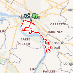
Randonnée V.T.T. de 13,8 km à découvrir à Nouvelle-Aquitaine, Lot-et-Garonne, Marmande. Cette randonnée est proposée par tracegps.
Description
Une balade au départ de Marmande, un maximum de sentiers en forêt. Quelques passages dans la pelouse en bordure de champs, ou sur les digues. La balade se termine par un tour dans le Parc de la Filhole pour terminer en douceur...
Localisation
Pays :
France
Région :
Nouvelle-Aquitaine
Département/Province :
Lot-et-Garonne
Commune :
Marmande
Localité :
Unknown
Départ:(Dec)
Départ:(UTM)
274771 ; 4930881 (31T) N.
Commentaires
Randonnées à proximité
![Randonnée V.T.T. Marmande - Marmande nocturne à VTT - Photo](https://media.geolcdn.com/t/375/260/ext.jpg?maxdim=2&url=https%3A%2F%2Fservices.sitytrail.com%2FGeolivesWS%2FDownloadMedia.ashx%3FTrailID%3D215046%26Media%3D15614_4.jpg)
![V.T.T. V.T.T.](https://static1.geolcdn.com/sitytour/trail-icons/202.png)
Marmande nocturne à VTT
V.T.T.
Facile
Marmande,
Nouvelle-Aquitaine,
Lot-et-Garonne,
France
![](/images/other/stat-length.png)
15,8 km | 17 km-effort
1h 10min
![](https://static1.geolcdn.com/siteimages/upload/files/16400158638029165_repeat_loop_refresh_sync_direction_icon.png)
Oui
![Randonnée Cheval Beaupuy - Beaupuy, randonnée dans les vignobles du Marmandais - Pays Val de Garonne - Gascogne - Photo](https://media.geolcdn.com/t/375/260/ext.jpg?maxdim=2&url=https%3A%2F%2Fservices.sitytrail.com%2FGeolivesWS%2FDownloadMedia.ashx%3FTrailID%3D111790%26Media%3D8330_1.jpg)
![Cheval Cheval](https://static1.geolcdn.com/sitytour/trail-icons/300.png)
Beaupuy, randonnée dans les vignobles du Marmandais - Pays Val de Garonne - G...
Cheval
Difficile
Beaupuy,
Nouvelle-Aquitaine,
Lot-et-Garonne,
France
![](/images/other/stat-length.png)
15 km | 19 km-effort
2h 34min
![](https://static1.geolcdn.com/siteimages/upload/files/16400158638029165_repeat_loop_refresh_sync_direction_icon.png)
Oui
![Randonnée V.T.T. Beaupuy - Beaupuy, randonnée dans les vignobles du Marmandais - Pays Val de Garonne - Gascogne - Photo](https://media.geolcdn.com/t/375/260/ext.jpg?maxdim=2&url=https%3A%2F%2Fservices.sitytrail.com%2FGeolivesWS%2FDownloadMedia.ashx%3FTrailID%3D111789%26Media%3D8330_1.jpg)
![V.T.T. V.T.T.](https://static1.geolcdn.com/sitytour/trail-icons/202.png)
Beaupuy, randonnée dans les vignobles du Marmandais - Pays Val de Garonne - G...
V.T.T.
Moyen
Beaupuy,
Nouvelle-Aquitaine,
Lot-et-Garonne,
France
![](/images/other/stat-length.png)
15 km | 19 km-effort
1h 55min
![](https://static1.geolcdn.com/siteimages/upload/files/16400158638029165_repeat_loop_refresh_sync_direction_icon.png)
Oui
![Randonnée Marche Beaupuy - Beaupuy, randonnée dans les vignobles du Marmandais - Pays Val de Garonne - Gascogne - Photo](https://media.geolcdn.com/t/375/260/ext.jpg?maxdim=2&url=https%3A%2F%2Fservices.sitytrail.com%2FGeolivesWS%2FDownloadMedia.ashx%3FTrailID%3D111788%26Media%3D8330_1.jpg)
![Marche Marche](https://static1.geolcdn.com/sitytour/trail-icons/101.png)
Beaupuy, randonnée dans les vignobles du Marmandais - Pays Val de Garonne - G...
Marche
Difficile
Beaupuy,
Nouvelle-Aquitaine,
Lot-et-Garonne,
France
![](/images/other/stat-length.png)
15 km | 19 km-effort
3h 49min
![](https://static1.geolcdn.com/siteimages/upload/files/16400158638029165_repeat_loop_refresh_sync_direction_icon.png)
Oui
![Randonnée V.T.T. Gaujac - Gaujac, un village de plaine entre la Garonne et son Canal - Pays Val de Garonne - Gascogne - Photo](https://media.geolcdn.com/t/375/260/ext.jpg?maxdim=2&url=https%3A%2F%2Fservices.sitytrail.com%2FGeolivesWS%2FDownloadMedia.ashx%3FTrailID%3D110705%26Media%3D6248_1.jpg)
![V.T.T. V.T.T.](https://static1.geolcdn.com/sitytour/trail-icons/202.png)
Gaujac, un village de plaine entre la Garonne et son Canal - Pays Val de Garo...
V.T.T.
Moyen
Gaujac,
Nouvelle-Aquitaine,
Lot-et-Garonne,
France
![](/images/other/stat-length.png)
9,2 km | 10,1 km-effort
1h 19min
![](https://static1.geolcdn.com/siteimages/upload/files/16400158638029165_repeat_loop_refresh_sync_direction_icon.png)
Oui
![Randonnée Marche Gaujac - Gaujac, un village de plaine entre la Garonne et son Canal - Pays Val de Garonne - Gascogne - Photo](https://media.geolcdn.com/t/375/260/ext.jpg?maxdim=2&url=https%3A%2F%2Fservices.sitytrail.com%2FGeolivesWS%2FDownloadMedia.ashx%3FTrailID%3D110704%26Media%3D6248_1.jpg)
![Marche Marche](https://static1.geolcdn.com/sitytour/trail-icons/101.png)
Gaujac, un village de plaine entre la Garonne et son Canal - Pays Val de Garo...
Marche
Moyen
Gaujac,
Nouvelle-Aquitaine,
Lot-et-Garonne,
France
![](/images/other/stat-length.png)
9,2 km | 10,1 km-effort
2h 45min
![](https://static1.geolcdn.com/siteimages/upload/files/16400158638029165_repeat_loop_refresh_sync_direction_icon.png)
Oui
![Randonnée Marche Marmande - piste cyclable - Photo](https://media.geolcdn.com/t/375/260/ext.jpg?maxdim=2&url=https%3A%2F%2Fstatic1.geolcdn.com%2Fsiteimages%2Fupload%2Ffiles%2F1553511878bg_sport_marche.png)
![Marche Marche](https://static1.geolcdn.com/sitytour/trail-icons/101.png)
piste cyclable
Marche
Facile
Marmande,
Nouvelle-Aquitaine,
Lot-et-Garonne,
France
![](/images/other/stat-length.png)
5,3 km | 5,8 km-effort
1h 2min
![](https://static1.geolcdn.com/siteimages/upload/files/16400158638029165_repeat_loop_refresh_sync_direction_icon.png)
Non
![Randonnée V.T.T. Marmande - Castelnau. 24 mai 2020 - Photo](https://media.geolcdn.com/t/375/260/ext.jpg?maxdim=2&url=https%3A%2F%2Fstatic1.geolcdn.com%2Fsiteimages%2Fupload%2Ffiles%2F1524743154velo.jpg)
![V.T.T. V.T.T.](https://static1.geolcdn.com/sitytour/trail-icons/202.png)
Castelnau. 24 mai 2020
V.T.T.
Marmande,
Nouvelle-Aquitaine,
Lot-et-Garonne,
France
![](/images/other/stat-length.png)
44 km | 53 km-effort
4h 8min
![](https://static1.geolcdn.com/siteimages/upload/files/16400158638029165_repeat_loop_refresh_sync_direction_icon.png)
Non
![Randonnée Vélo de route Marmande - Vélo - Photo](https://media.geolcdn.com/t/375/260/ext.jpg?maxdim=2&url=https%3A%2F%2Fstatic1.geolcdn.com%2Fsiteimages%2Fupload%2Ffiles%2F1524743154velo.jpg)
![Vélo de route Vélo de route](https://static1.geolcdn.com/sitytour/trail-icons/201.png)
Vélo
Vélo de route
Marmande,
Nouvelle-Aquitaine,
Lot-et-Garonne,
France
![](/images/other/stat-length.png)
9,9 km | 10,5 km-effort
50min
![](https://static1.geolcdn.com/siteimages/upload/files/16400158638029165_repeat_loop_refresh_sync_direction_icon.png)
Oui