![](/images/other/stat-length.png)
![Randonnée Marche Saint-Étienne-de-Tinée - Mont Ténibre en boucle depuis Saint Etienne de Tinée - Photo](https://media.geolcdn.com/t/1900/400/ext.pjpeg?maxdim=2&url=https%3A%2F%2Fservices.sitytrail.com%2FGeolivesWS%2FDownloadMedia.ashx%3FTrailID%3D316962%26Media%3D16081_1.jpg)
Mont Ténibre en boucle depuis Saint Etienne de Tinée
tracegps
Utilisateur
![Longueur](/images/other/stat-length.png)
![Altitude max](https://static1.geolcdn.com/siteimages/upload/files/1508320355ic_sort_altitude_max_24dp.png)
![Dénivelé positif](https://static1.geolcdn.com/siteimages/upload/files/1508320355ic_sort_den_pos_24dp.png)
![Km-Effort](/images/other/stat-length.png)
![Altitude min](https://static1.geolcdn.com/siteimages/upload/files/1508320355ic_sort_altitude_min_24dp.png)
![Dénivelé négatif](https://static1.geolcdn.com/siteimages/upload/files/1508320355ic_sort_den_neg_24dp.png)
![Boucle](https://static1.geolcdn.com/siteimages/upload/files/16400158638029165_repeat_loop_refresh_sync_direction_icon.png)
![Marche](https://static1.geolcdn.com/sitytour/trail-icons/101.png)
10h00
Difficulté : Très difficile
![Scannez ce code QR pour ouvrir la randonnée dans l'application SityTrail](https://capi.geolives.com/qq0zvz2zws4bq2lad0pu/sitytour/trails/316962/qr.png?size=200)
Application GPS de randonnée GRATUITE
À propos
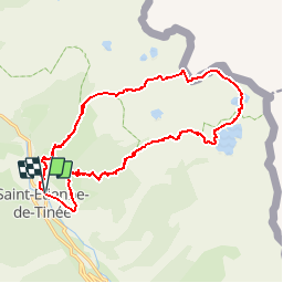
Randonnée Marche de 18 km à découvrir à Provence-Alpes-Côte d'Azur, Alpes-Maritimes, Saint-Étienne-de-Tinée. Cette randonnée est proposée par tracegps.
Description
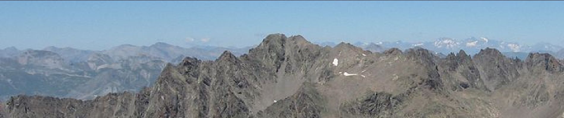
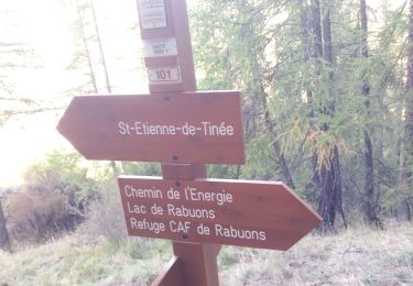
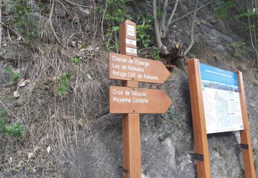
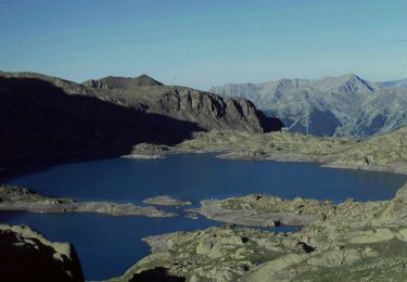
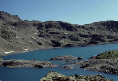
Le Ténibre, qui culmine à 3031 mètres, est le point culminant de la Haute Tinée. Le circuit, en boucle depuis Saint-Etienne-de-Tinée, y accède par le Lac des Rabuons, le plus grand lac des Alpes Maritimes, et en revient par Plan de Ténibre. Cette randonnée peut s'effectuer en 1 ou 2 jours en couchant au Refuge des Rabuons. Il s'agit d'un circuit pour randonneur expérimenté sachant qu'il ya quelques pas d'escalade F peu avant l'arrivée au sommet du Ténibre. Description complète sur toujoursplushaut .
Points d'intérêt
Localisation
Commentaires
Randonnées à proximité
![Randonnée Marche Saint-Étienne-de-Tinée - MERCANTOUR - Lac de rabuons - Photo](https://media.geolcdn.com/t/375/260/9be970a9-36fb-4800-8850-f3d8a283d146.jpg&format=jpg&maxdim=2)
![Marche Marche](https://static1.geolcdn.com/sitytour/trail-icons/101.png)
Marche
![](/images/other/stat-length.png)
![](https://static1.geolcdn.com/siteimages/upload/files/16400158638029165_repeat_loop_refresh_sync_direction_icon.png)
![Randonnée Marche Saint-Étienne-de-Tinée - Lacs de Rabuons et Chaffour - Photo](https://media.geolcdn.com/t/375/260/3c095966-4d41-4343-af9e-eff2f1957790.jpg&format=jpg&maxdim=2)
![Marche Marche](https://static1.geolcdn.com/sitytour/trail-icons/101.png)
Marche
![](/images/other/stat-length.png)
![](https://static1.geolcdn.com/siteimages/upload/files/16400158638029165_repeat_loop_refresh_sync_direction_icon.png)
![Randonnée Marche Saint-Étienne-de-Tinée - Refuge du Rabuons -- Mt Ténibre A/R -- St Etienne de Tinée - Photo](https://media.geolcdn.com/t/375/260/994ef0cf-20db-466f-991e-cc6124ac559b.jpg&format=jpg&maxdim=2)
![Marche Marche](https://static1.geolcdn.com/sitytour/trail-icons/101.png)
Marche
![](/images/other/stat-length.png)
![](https://static1.geolcdn.com/siteimages/upload/files/16400158638029165_repeat_loop_refresh_sync_direction_icon.png)
![Randonnée A pied Saint-Étienne-de-Tinée - Circuit du Bois d'Anelle - Photo](https://media.geolcdn.com/t/375/260/33170b65-b2a2-4258-939b-53929311e4fe.jpeg&format=jpg&maxdim=2)
![A pied A pied](https://static1.geolcdn.com/sitytour/trail-icons/100.png)
A pied
![](/images/other/stat-length.png)
![](https://static1.geolcdn.com/siteimages/upload/files/16400158638029165_repeat_loop_refresh_sync_direction_icon.png)
![Randonnée A pied Saint-Étienne-de-Tinée - Circuit de Selasse - Photo](https://media.geolcdn.com/t/375/260/dfb717e2-6ad9-4c5c-8a23-b53a05088fa8.jpeg&format=jpg&maxdim=2)
![A pied A pied](https://static1.geolcdn.com/sitytour/trail-icons/100.png)
A pied
![](/images/other/stat-length.png)
![](https://static1.geolcdn.com/siteimages/upload/files/16400158638029165_repeat_loop_refresh_sync_direction_icon.png)
![Randonnée A pied Saint-Étienne-de-Tinée - Cime de la Bercha - Photo](https://media.geolcdn.com/t/375/260/06e4d46f-e317-406d-bd2c-01041e541c38.jpeg&format=jpg&maxdim=2)
![A pied A pied](https://static1.geolcdn.com/sitytour/trail-icons/100.png)
A pied
![](/images/other/stat-length.png)
![](https://static1.geolcdn.com/siteimages/upload/files/16400158638029165_repeat_loop_refresh_sync_direction_icon.png)
![Randonnée A pied Saint-Étienne-de-Tinée - Chemin de l'Energie - Etape 3 - Photo](https://media.geolcdn.com/t/375/260/45dc2ef9-a27b-439a-8012-c03ab217c2f9.jpeg&format=jpg&maxdim=2)
![A pied A pied](https://static1.geolcdn.com/sitytour/trail-icons/100.png)
A pied
![](/images/other/stat-length.png)
![](https://static1.geolcdn.com/siteimages/upload/files/16400158638029165_repeat_loop_refresh_sync_direction_icon.png)
![Randonnée A pied Saint-Étienne-de-Tinée - Mont Ténibre - Photo](https://media.geolcdn.com/t/375/260/e4d2ef1c-7332-48ac-8d35-d330e68b6f30.jpeg&format=jpg&maxdim=2)
![A pied A pied](https://static1.geolcdn.com/sitytour/trail-icons/100.png)
A pied
![](/images/other/stat-length.png)
![](https://static1.geolcdn.com/siteimages/upload/files/16400158638029165_repeat_loop_refresh_sync_direction_icon.png)
![Randonnée A pied Saint-Étienne-de-Tinée - Mont Ténibre - Etape 1 - Photo](https://media.geolcdn.com/t/375/260/0ae9acc1-b5e7-475c-ba30-b123ec5f057b.jpeg&format=jpg&maxdim=2)
![A pied A pied](https://static1.geolcdn.com/sitytour/trail-icons/100.png)
A pied
![](/images/other/stat-length.png)
![](https://static1.geolcdn.com/siteimages/upload/files/16400158638029165_repeat_loop_refresh_sync_direction_icon.png)