![](/images/other/stat-length.png)
![Randonnée Marche nordique Jarrie - Au départ de l'Eglise de Saint-Etienne, circuit par Montchaboud - Photo](https://media.geolcdn.com/t/1900/400/c4f92672-0fc8-4366-972f-0eadf8a2b929.jpg&format=pjpeg&maxdim=2)
Au départ de l'Eglise de Saint-Etienne, circuit par Montchaboud
Emelle
Utilisateur
![Longueur](/images/other/stat-length.png)
Longueur
9,3 km
![Altitude max](https://static1.geolcdn.com/siteimages/upload/files/1508320355ic_sort_altitude_max_24dp.png)
Altitude max
588 m
![Dénivelé positif](https://static1.geolcdn.com/siteimages/upload/files/1508320355ic_sort_den_pos_24dp.png)
Dénivelé positif
321 m
![Km-Effort](/images/other/stat-length.png)
Km-Effort
13,6 km
![Altitude min](https://static1.geolcdn.com/siteimages/upload/files/1508320355ic_sort_altitude_min_24dp.png)
Altitude min
356 m
![Dénivelé négatif](https://static1.geolcdn.com/siteimages/upload/files/1508320355ic_sort_den_neg_24dp.png)
Dénivelé négatif
320 m
![Boucle](https://static1.geolcdn.com/siteimages/upload/files/16400158638029165_repeat_loop_refresh_sync_direction_icon.png)
Boucle
Oui
Date de création :
2022-03-16 08:02:10.315
Dernière modification :
2022-03-16 14:11:49.591
![Marche nordique](https://static1.geolcdn.com/sitytour/trail-icons/102.png)
3h10
Difficulté : Facile
![Scannez ce code QR pour ouvrir la randonnée dans l'application SityTrail](https://capi.geolives.com/qq0zvz2zws4bq2lad0pu/sitytour/trails/3168916/qr.png?size=200)
Application GPS de randonnée GRATUITE
À propos
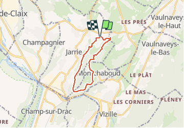
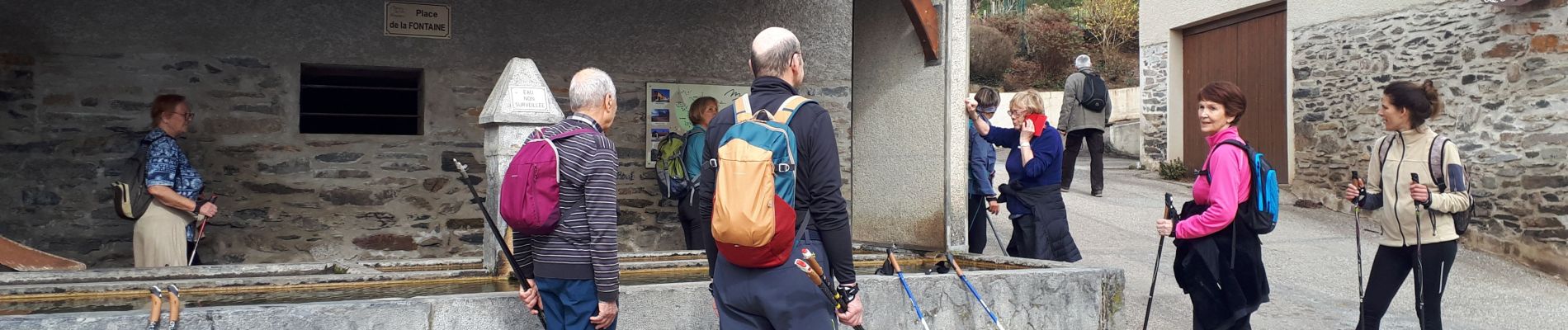
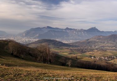
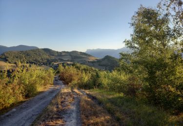
Randonnée Marche nordique de 9,3 km à découvrir à Auvergne-Rhône-Alpes, Isère, Jarrie. Cette randonnée est proposée par Emelle.
Description
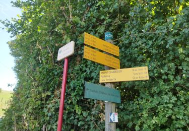
Une remontée sur la fin assez raide peu compatible avec la MN à éviter la prochaine fois en coupant avant.
Sinon de belles portions se prêtent bien dans l'ensemble à l'activité Marche Nordique.
Localisation
Pays :
France
Région :
Auvergne-Rhône-Alpes
Département/Province :
Isère
Commune :
Jarrie
Localité :
Unknown
Départ:(Dec)
Départ:(UTM)
717626 ; 4999172 (31T) N.
Commentaires
Randonnées à proximité
![Randonnée A pied Saint-Martin-d'Uriage - Circuit des Curistes - Photo](https://media.geolcdn.com/t/375/260/884736af-6d5e-4498-9816-404871d42486.jpeg&format=jpg&maxdim=2)
![A pied A pied](https://static1.geolcdn.com/sitytour/trail-icons/100.png)
Circuit des Curistes
A pied
Facile
Saint-Martin-d'Uriage,
Auvergne-Rhône-Alpes,
Isère,
France
![](/images/other/stat-length.png)
5,9 km | 7,8 km-effort
1h 46min
![](https://static1.geolcdn.com/siteimages/upload/files/16400158638029165_repeat_loop_refresh_sync_direction_icon.png)
Oui
![Randonnée A pied Saint-Martin-d'Uriage - Circuit des Crêtes - Photo](https://media.geolcdn.com/t/375/260/a077f9fa-48e4-483f-a273-f9f858afd6d0.jpeg&format=jpg&maxdim=2)
![A pied A pied](https://static1.geolcdn.com/sitytour/trail-icons/100.png)
Circuit des Crêtes
A pied
Facile
Saint-Martin-d'Uriage,
Auvergne-Rhône-Alpes,
Isère,
France
![](/images/other/stat-length.png)
9,5 km | 13,6 km-effort
3h 5min
![](https://static1.geolcdn.com/siteimages/upload/files/16400158638029165_repeat_loop_refresh_sync_direction_icon.png)
Oui
![Randonnée Course à pied Vizille - Echappée Belle 2013 - Photo](https://media.geolcdn.com/t/375/260/ext.jpg?maxdim=2&url=https%3A%2F%2Fstatic1.geolcdn.com%2Fsiteimages%2Fupload%2Ffiles%2F1524743154running.jpg)
![Course à pied Course à pied](https://static1.geolcdn.com/sitytour/trail-icons/103.png)
Echappée Belle 2013
Course à pied
Très difficile
(1)
Vizille,
Auvergne-Rhône-Alpes,
Isère,
France
![](/images/other/stat-length.png)
136 km | 279 km-effort
60h 0min
![](https://static1.geolcdn.com/siteimages/upload/files/16400158638029165_repeat_loop_refresh_sync_direction_icon.png)
Non
![Randonnée Marche Champ-sur-Drac - 38 Couvent St Michel Champ / drac - Photo](https://media.geolcdn.com/t/375/260/2541c209-e2b9-4fc5-ac0c-29659bf67ee5.jpg&format=jpg&maxdim=2)
![Marche Marche](https://static1.geolcdn.com/sitytour/trail-icons/101.png)
38 Couvent St Michel Champ / drac
Marche
Moyen
Champ-sur-Drac,
Auvergne-Rhône-Alpes,
Isère,
France
![](/images/other/stat-length.png)
9,4 km | 19,7 km-effort
3h 0min
![](https://static1.geolcdn.com/siteimages/upload/files/16400158638029165_repeat_loop_refresh_sync_direction_icon.png)
Oui
![Randonnée Marche Varces-Allières-et-Risset - Les Etangs de Reymure réaménagés en 2023. - Photo](https://media.geolcdn.com/t/375/260/a9036917-cc32-4324-8d0a-4d872f501612.jpg&format=jpg&maxdim=2)
![Marche Marche](https://static1.geolcdn.com/sitytour/trail-icons/101.png)
Les Etangs de Reymure réaménagés en 2023.
Marche
Moyen
Varces-Allières-et-Risset,
Auvergne-Rhône-Alpes,
Isère,
France
![](/images/other/stat-length.png)
7,9 km | 8,6 km-effort
2h 35min
![](https://static1.geolcdn.com/siteimages/upload/files/16400158638029165_repeat_loop_refresh_sync_direction_icon.png)
Oui
![Randonnée Marche nordique Jarrie - Mon chabou -haut jarret - Photo](https://media.geolcdn.com/t/375/260/8d9b08e7-4849-40d2-bae6-1be2c82dc5a3.jpg&format=jpg&maxdim=2)
![Marche nordique Marche nordique](https://static1.geolcdn.com/sitytour/trail-icons/102.png)
Mon chabou -haut jarret
Marche nordique
Très facile
Jarrie,
Auvergne-Rhône-Alpes,
Isère,
France
![](/images/other/stat-length.png)
10,2 km | 14,6 km-effort
2h 21min
![](https://static1.geolcdn.com/siteimages/upload/files/16400158638029165_repeat_loop_refresh_sync_direction_icon.png)
Oui
![Randonnée Marche Brié-et-Angonnes - Brié - Montchabout - Sommet de Pravena - Photo](https://media.geolcdn.com/t/375/260/0f2df736-86ba-41cf-8335-b76275aca73b.jpg&format=jpg&maxdim=2)
![Marche Marche](https://static1.geolcdn.com/sitytour/trail-icons/101.png)
Brié - Montchabout - Sommet de Pravena
Marche
Moyen
Brié-et-Angonnes,
Auvergne-Rhône-Alpes,
Isère,
France
![](/images/other/stat-length.png)
14,5 km | 23 km-effort
4h 19min
![](https://static1.geolcdn.com/siteimages/upload/files/16400158638029165_repeat_loop_refresh_sync_direction_icon.png)
Oui
![Randonnée Marche Vaulnaveys-le-Bas - Montchaffrey/chartreuse de premol - Photo](https://media.geolcdn.com/t/375/260/bb0c8a32-d481-4cd5-bf35-438acdb94f2e.jpg&format=jpg&maxdim=2)
![Marche Marche](https://static1.geolcdn.com/sitytour/trail-icons/101.png)
Montchaffrey/chartreuse de premol
Marche
Très difficile
Vaulnaveys-le-Bas,
Auvergne-Rhône-Alpes,
Isère,
France
![](/images/other/stat-length.png)
15 km | 23 km-effort
3h 54min
![](https://static1.geolcdn.com/siteimages/upload/files/16400158638029165_repeat_loop_refresh_sync_direction_icon.png)
Oui
![Randonnée Marche Brié-et-Angonnes - Brié- Table d'orientation - Photo](https://media.geolcdn.com/t/375/260/7bbbe70d-bffa-4966-9f56-9fa776cf97b0.jpg&format=jpg&maxdim=2)
![Marche Marche](https://static1.geolcdn.com/sitytour/trail-icons/101.png)
Brié- Table d'orientation
Marche
Très facile
Brié-et-Angonnes,
Auvergne-Rhône-Alpes,
Isère,
France
![](/images/other/stat-length.png)
3,1 km | 4,3 km-effort
59min
![](https://static1.geolcdn.com/siteimages/upload/files/16400158638029165_repeat_loop_refresh_sync_direction_icon.png)
Oui