![](/images/other/stat-length.png)
![Randonnée Marche Esparron - Rocher de Saint-Pierre - Photo](https://media.geolcdn.com/t/1900/400/9d0b67b9-2311-4064-b840-1168dbdf7ac7.jpg&format=pjpeg&maxdim=2)
Rocher de Saint-Pierre
PapouBertrand
Utilisateur
![Longueur](/images/other/stat-length.png)
Longueur
6,8 km
![Altitude max](https://static1.geolcdn.com/siteimages/upload/files/1508320355ic_sort_altitude_max_24dp.png)
Altitude max
1423 m
![Dénivelé positif](https://static1.geolcdn.com/siteimages/upload/files/1508320355ic_sort_den_pos_24dp.png)
Dénivelé positif
465 m
![Km-Effort](/images/other/stat-length.png)
Km-Effort
13 km
![Altitude min](https://static1.geolcdn.com/siteimages/upload/files/1508320355ic_sort_altitude_min_24dp.png)
Altitude min
968 m
![Dénivelé négatif](https://static1.geolcdn.com/siteimages/upload/files/1508320355ic_sort_den_neg_24dp.png)
Dénivelé négatif
466 m
![Boucle](https://static1.geolcdn.com/siteimages/upload/files/16400158638029165_repeat_loop_refresh_sync_direction_icon.png)
Boucle
Oui
Date de création :
2022-03-15 08:26:16.045
Dernière modification :
2022-03-16 15:16:10.99
![Marche](https://static1.geolcdn.com/sitytour/trail-icons/101.png)
4h06
Difficulté : Moyen
![Scannez ce code QR pour ouvrir la randonnée dans l'application SityTrail](https://capi.geolives.com/qq0zvz2zws4bq2lad0pu/sitytour/trails/3168584/qr.png?size=200)
Application GPS de randonnée GRATUITE
À propos
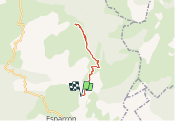
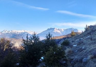
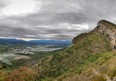
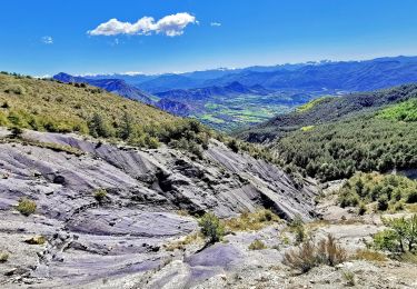
Randonnée Marche de 6,8 km à découvrir à Provence-Alpes-Côte d'Azur, Hautes-Alpes, Esparron. Cette randonnée est proposée par PapouBertrand.
Description
Rocher de Saint-Pierre via Esparron. Pour éviter les broussailles, prendre à gauche avant le col de la Baume (versant Ouest) puis prendre versant Est à partir de la chapelle St-Pierre.
Localisation
Pays :
France
Région :
Provence-Alpes-Côte d'Azur
Département/Province :
Hautes-Alpes
Commune :
Esparron
Localité :
Unknown
Départ:(Dec)
Départ:(UTM)
731495 ; 4926973 (31T) N.
Commentaires
Randonnées à proximité
![Randonnée Trail Châteauneuf-d'Oze - Tour et sommet petite Céüse - Photo](https://media.geolcdn.com/t/375/260/35ba00a4-91ec-4796-9ff5-ca90e4bc8831.jpg&format=jpg&maxdim=2)
![Trail Trail](https://static1.geolcdn.com/sitytour/trail-icons/104.png)
Tour et sommet petite Céüse
Trail
Moyen
Châteauneuf-d'Oze,
Provence-Alpes-Côte d'Azur,
Hautes-Alpes,
France
![](/images/other/stat-length.png)
11,8 km | 22 km-effort
2h 10min
![](https://static1.geolcdn.com/siteimages/upload/files/16400158638029165_repeat_loop_refresh_sync_direction_icon.png)
Oui
![Randonnée Marche Sigoyer - corniche de Ceüze tour - Photo](https://media.geolcdn.com/t/375/260/606b8b0a-ef0b-4016-a35b-711cbf3016a8.jpg&format=jpg&maxdim=2)
![Marche Marche](https://static1.geolcdn.com/sitytour/trail-icons/101.png)
corniche de Ceüze tour
Marche
Moyen
Sigoyer,
Provence-Alpes-Côte d'Azur,
Hautes-Alpes,
France
![](/images/other/stat-length.png)
15,7 km | 28 km-effort
4h 13min
![](https://static1.geolcdn.com/siteimages/upload/files/16400158638029165_repeat_loop_refresh_sync_direction_icon.png)
Oui
![Randonnée Marche Vitrolles - Pic de Crigne - Photo](https://media.geolcdn.com/t/375/260/8de24f96-abb9-4a59-92c3-86b70c658bb0.jpg&format=jpg&maxdim=2)
![Marche Marche](https://static1.geolcdn.com/sitytour/trail-icons/101.png)
Pic de Crigne
Marche
Moyen
Vitrolles,
Provence-Alpes-Côte d'Azur,
Hautes-Alpes,
France
![](/images/other/stat-length.png)
5,9 km | 14,3 km-effort
3h 14min
![](https://static1.geolcdn.com/siteimages/upload/files/16400158638029165_repeat_loop_refresh_sync_direction_icon.png)
Oui
![Randonnée Marche Sigoyer - Petite Ceüze - Photo](https://media.geolcdn.com/t/375/260/a4aca269-bd26-4bc0-bc52-b9c9a64b1557.jpg&format=jpg&maxdim=2)
![Marche Marche](https://static1.geolcdn.com/sitytour/trail-icons/101.png)
Petite Ceüze
Marche
Moyen
Sigoyer,
Provence-Alpes-Côte d'Azur,
Hautes-Alpes,
France
![](/images/other/stat-length.png)
11,6 km | 22 km-effort
4h 54min
![](https://static1.geolcdn.com/siteimages/upload/files/16400158638029165_repeat_loop_refresh_sync_direction_icon.png)
Oui
![Randonnée Marche Esparron - ESPARON 05 . Lac de Peyssier . Col de Peyssier o s - Photo](https://media.geolcdn.com/t/375/260/0f9bb5cb-cbd8-4244-8a0b-6a9c6c8c6e0b.jpg&format=jpg&maxdim=2)
![Marche Marche](https://static1.geolcdn.com/sitytour/trail-icons/101.png)
ESPARON 05 . Lac de Peyssier . Col de Peyssier o s
Marche
Difficile
Esparron,
Provence-Alpes-Côte d'Azur,
Hautes-Alpes,
France
![](/images/other/stat-length.png)
15,9 km | 25 km-effort
4h 38min
![](https://static1.geolcdn.com/siteimages/upload/files/16400158638029165_repeat_loop_refresh_sync_direction_icon.png)
Oui
![Randonnée Course à pied Saint-Auban-d'Oze - Trail 01 - Le Cirque de Villauret - Photo](https://media.geolcdn.com/t/375/260/11438a15-97de-46a3-a3f1-adac73a9fffe.jpg&format=jpg&maxdim=2)
![Course à pied Course à pied](https://static1.geolcdn.com/sitytour/trail-icons/103.png)
Trail 01 - Le Cirque de Villauret
Course à pied
Difficile
Saint-Auban-d'Oze,
Provence-Alpes-Côte d'Azur,
Hautes-Alpes,
France
![](/images/other/stat-length.png)
9,6 km | 19,9 km-effort
2h 0min
![](https://static1.geolcdn.com/siteimages/upload/files/16400158638029165_repeat_loop_refresh_sync_direction_icon.png)
Oui
![Randonnée Marche Vitrolles - Pic de Crigne - Photo](https://media.geolcdn.com/t/375/260/c57ec1d9-7b0a-459e-886f-cd7864baade1.jpg&format=jpg&maxdim=2)
![Marche Marche](https://static1.geolcdn.com/sitytour/trail-icons/101.png)
Pic de Crigne
Marche
Très difficile
Vitrolles,
Provence-Alpes-Côte d'Azur,
Hautes-Alpes,
France
![](/images/other/stat-length.png)
11,6 km | 21 km-effort
5h 33min
![](https://static1.geolcdn.com/siteimages/upload/files/16400158638029165_repeat_loop_refresh_sync_direction_icon.png)
Non
![Randonnée Marche Sigoyer - Montee de la petite Ceüz - Photo](https://media.geolcdn.com/t/375/260/c451b738-3373-4def-b17a-1e98f6c7c0dd.jpg&format=jpg&maxdim=2)
![Marche Marche](https://static1.geolcdn.com/sitytour/trail-icons/101.png)
Montee de la petite Ceüz
Marche
Facile
Sigoyer,
Provence-Alpes-Côte d'Azur,
Hautes-Alpes,
France
![](/images/other/stat-length.png)
3 km | 6,8 km-effort
1h 27min
![](https://static1.geolcdn.com/siteimages/upload/files/16400158638029165_repeat_loop_refresh_sync_direction_icon.png)
Non
![Randonnée Marche Esparron - Montagne de Rochefort via Esparron - Photo](https://media.geolcdn.com/t/375/260/a9afae64-dc46-4a24-9d5a-88e4f626d203.jpg&format=jpg&maxdim=2)
![Marche Marche](https://static1.geolcdn.com/sitytour/trail-icons/101.png)
Montagne de Rochefort via Esparron
Marche
Très difficile
Esparron,
Provence-Alpes-Côte d'Azur,
Hautes-Alpes,
France
![](/images/other/stat-length.png)
12,6 km | 24 km-effort
6h 12min
![](https://static1.geolcdn.com/siteimages/upload/files/16400158638029165_repeat_loop_refresh_sync_direction_icon.png)
Oui