![](/images/other/stat-length.png)
![Randonnée Marche Verchaix - La Pointe d'Angolon 2090 m, depuis les Chalets de Joux Plane - Photo](https://media.geolcdn.com/t/1900/400/ext.pjpeg?maxdim=2&url=https%3A%2F%2Fservices.sitytrail.com%2FGeolivesWS%2FDownloadMedia.ashx%3FTrailID%3D316829%26Media%3D15889_1.jpg)
La Pointe d'Angolon 2090 m, depuis les Chalets de Joux Plane
tracegps
Utilisateur
![Longueur](/images/other/stat-length.png)
![Altitude max](https://static1.geolcdn.com/siteimages/upload/files/1508320355ic_sort_altitude_max_24dp.png)
![Dénivelé positif](https://static1.geolcdn.com/siteimages/upload/files/1508320355ic_sort_den_pos_24dp.png)
![Km-Effort](/images/other/stat-length.png)
![Altitude min](https://static1.geolcdn.com/siteimages/upload/files/1508320355ic_sort_altitude_min_24dp.png)
![Dénivelé négatif](https://static1.geolcdn.com/siteimages/upload/files/1508320355ic_sort_den_neg_24dp.png)
![Boucle](https://static1.geolcdn.com/siteimages/upload/files/16400158638029165_repeat_loop_refresh_sync_direction_icon.png)
![Marche](https://static1.geolcdn.com/sitytour/trail-icons/101.png)
4h00
Difficulté : Difficile
![Scannez ce code QR pour ouvrir la randonnée dans l'application SityTrail](https://capi.geolives.com/qq0zvz2zws4bq2lad0pu/sitytour/trails/316829/qr.png?size=200)
Application GPS de randonnée GRATUITE
À propos
Randonnée Marche de 6,9 km à découvrir à Auvergne-Rhône-Alpes, Haute-Savoie, Verchaix. Cette randonnée est proposée par tracegps.
Description
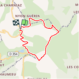
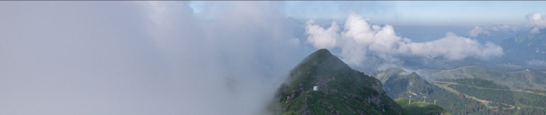
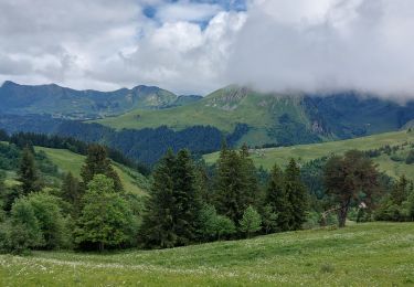
Sans un brouillard persistant, la Pointe d'Angolon aurait offert une vue intéressante sur les Dents du Midi et la Tête de Bostan. La traversée de la Pointe d'Angolon est une courte randonnée intéressante qui présente un dénivelé équilibré en partant des Chalets de Joux Plane. Passant par le Col de Joux Plane, l'itinéraire rejoint la crête de la Pointe de Chamossière au point 1804 pour la suivre en direction du Collu et enfin de la Pointe d'Angolon. La descente de l'arête Nord Ouest permet un circuit varié qui passe par le Lac de Nyon Guérin pour retrouver le pointe de départ. Description complète sur sentier-nature.com : La Pointe d'Angolon 2090 m, depuis les Chalets de Joux Plane Avertissement [Franchissement 1/3 ; Exposition 2/3 ; Pénibilité 2/3]. Certains passages de cet itinéraire de montagne sont escarpés et/ou exposés, il est déconseillé aux enfants non accompagnés et aux personnes sujettes au vertige. Pour votre sécurité, nous vous invitons à respecter les règles suivantes : être bien chaussé, ne pas s'engager par mauvais temps, ne pas s'écarter de l'itinéraire ni des sentiers. Il apparaît souhaitable de réaliser cette course par temps sec.
Localisation
Commentaires
Randonnées à proximité
![Randonnée Marche Morzine - Les Hauts-Forts, Col de l'Encarnette, 2359m - Photo](https://media.geolcdn.com/t/375/260/ext.jpg?maxdim=2&url=https%3A%2F%2Fservices.sitytrail.com%2FGeolivesWS%2FDownloadMedia.ashx%3FTrailID%3D172633%26Media%3D14002_1.jpg)
![Marche Marche](https://static1.geolcdn.com/sitytour/trail-icons/101.png)
Marche
![](/images/other/stat-length.png)
![](https://static1.geolcdn.com/siteimages/upload/files/16400158638029165_repeat_loop_refresh_sync_direction_icon.png)
![Randonnée Marche Samoëns - La Tête de Bostan - Photo](https://media.geolcdn.com/t/375/260/ext.jpg?maxdim=2&url=https%3A%2F%2Fstatic1.geolcdn.com%2Fsiteimages%2Fupload%2Ffiles%2F1553511878bg_sport_marche.png)
![Marche Marche](https://static1.geolcdn.com/sitytour/trail-icons/101.png)
Marche
![](/images/other/stat-length.png)
![](https://static1.geolcdn.com/siteimages/upload/files/16400158638029165_repeat_loop_refresh_sync_direction_icon.png)
![Randonnée Ski de randonnée Samoëns - 2025-01-30 Sortie Ski de Rando Col de la Golese - Photo](https://media.geolcdn.com/t/375/260/5172d417-9875-43d9-89bb-031c8ee85781.jpg&format=jpg&maxdim=2)
![Ski de randonnée Ski de randonnée](https://static1.geolcdn.com/sitytour/trail-icons/503.png)
Ski de randonnée
![](/images/other/stat-length.png)
![](https://static1.geolcdn.com/siteimages/upload/files/16400158638029165_repeat_loop_refresh_sync_direction_icon.png)
![Randonnée Marche Verchaix - col de joux plane - Photo](https://media.geolcdn.com/t/375/260/f5f22de2-b8d8-4ec7-857b-352656491634.jpg&format=jpg&maxdim=2)
![Marche Marche](https://static1.geolcdn.com/sitytour/trail-icons/101.png)
Marche
![](/images/other/stat-length.png)
![](https://static1.geolcdn.com/siteimages/upload/files/16400158638029165_repeat_loop_refresh_sync_direction_icon.png)
![Randonnée Marche Samoëns - La tête de Bostan - Photo](https://media.geolcdn.com/t/375/260/c42830f7-a262-4abd-8f00-d269896222b2.jpg&format=jpg&maxdim=2)
![Marche Marche](https://static1.geolcdn.com/sitytour/trail-icons/101.png)
Marche
![](/images/other/stat-length.png)
![](https://static1.geolcdn.com/siteimages/upload/files/16400158638029165_repeat_loop_refresh_sync_direction_icon.png)
![Randonnée Marche Morzine - morzine la cime de Nyon - Photo](https://media.geolcdn.com/t/375/260/9cf9770f-202e-49ec-8ef9-b204d4b5c2e6.jpg&format=jpg&maxdim=2)
![Marche Marche](https://static1.geolcdn.com/sitytour/trail-icons/101.png)
Marche
![](/images/other/stat-length.png)
![](https://static1.geolcdn.com/siteimages/upload/files/16400158638029165_repeat_loop_refresh_sync_direction_icon.png)
![Randonnée Marche Les Gets - morzine col du mont chery - Photo](https://media.geolcdn.com/t/375/260/15b7d016-07a2-4cc1-9bc8-ccf4c00982d5.jpg&format=jpg&maxdim=2)
![Marche Marche](https://static1.geolcdn.com/sitytour/trail-icons/101.png)
Marche
![](/images/other/stat-length.png)
![](https://static1.geolcdn.com/siteimages/upload/files/16400158638029165_repeat_loop_refresh_sync_direction_icon.png)
![Randonnée Marche Samoëns - SAMOENS: LES ALLAMANDS - BOSTAN (CHALETS - REFUGE - COL - TETE) - GOLESE - Photo](https://media.geolcdn.com/t/375/260/c5ba1cee-0408-4163-a2ab-ac65d7121802.jpg&format=jpg&maxdim=2)
![Marche Marche](https://static1.geolcdn.com/sitytour/trail-icons/101.png)
Marche
![](/images/other/stat-length.png)
![](https://static1.geolcdn.com/siteimages/upload/files/16400158638029165_repeat_loop_refresh_sync_direction_icon.png)
![Randonnée Marche Samoëns - SAMOENS: LAC DES CHAMBRES - Photo](https://media.geolcdn.com/t/375/260/cd8f3e5f-51d1-4c9a-9456-e0bd19938b89.jpg&format=jpg&maxdim=2)
![Marche Marche](https://static1.geolcdn.com/sitytour/trail-icons/101.png)
Marche
![](/images/other/stat-length.png)
![](https://static1.geolcdn.com/siteimages/upload/files/16400158638029165_repeat_loop_refresh_sync_direction_icon.png)