![](/images/other/stat-length.png)
![Randonnée Marche Lanildut - GR 34® de Lanildut au Conquet - Photo](https://media.geolcdn.com/t/1900/400/ext.pjpeg?maxdim=2&url=https%3A%2F%2Fservices.sitytrail.com%2FGeolivesWS%2FDownloadMedia.ashx%3FTrailID%3D316782%26Media%3D5188_1.jpg)
GR 34® de Lanildut au Conquet
tracegps
Utilisateur
![Longueur](/images/other/stat-length.png)
![Altitude max](https://static1.geolcdn.com/siteimages/upload/files/1508320355ic_sort_altitude_max_24dp.png)
![Dénivelé positif](https://static1.geolcdn.com/siteimages/upload/files/1508320355ic_sort_den_pos_24dp.png)
![Km-Effort](/images/other/stat-length.png)
![Altitude min](https://static1.geolcdn.com/siteimages/upload/files/1508320355ic_sort_altitude_min_24dp.png)
![Dénivelé négatif](https://static1.geolcdn.com/siteimages/upload/files/1508320355ic_sort_den_neg_24dp.png)
![Boucle](https://static1.geolcdn.com/siteimages/upload/files/16400158638029165_repeat_loop_refresh_sync_direction_icon.png)
![Marche](https://static1.geolcdn.com/sitytour/trail-icons/101.png)
8h00
Difficulté : Très difficile
![Scannez ce code QR pour ouvrir la randonnée dans l'application SityTrail](https://capi.geolives.com/qq0zvz2zws4bq2lad0pu/sitytour/trails/316782/qr.png?size=200)
Application GPS de randonnée GRATUITE
À propos
Randonnée Marche de 36 km à découvrir à Bretagne, Finistère, Lanildut. Cette randonnée est proposée par tracegps.
Description
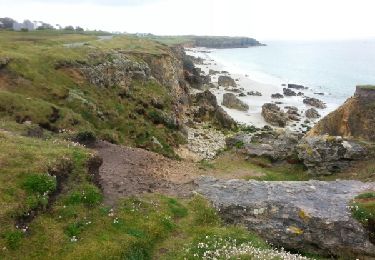
GR 34® de Lanildut au Conquet. Port crabier important, Le Conquet est également devenu un lieu de production réputé pour le poisson noble. Depuis quelques années, la flottille a diversifié ses activités : à côté des caseyeurs traditionnels pratiquant la pêche au tourteau se sont développés les fileyeurs qui ramènent lotte, raie, barbue, turbot ou langouste ainsi que du poisson de petite pêche, frais du jour. Le tourteau demeure néanmoins le symbole du port du bout du monde.(source Wikipédia) Vous trouverez le descriptif détaillé de cette randonnée dans le Topo-guide® de la Fédération Française de la Randonnée Pédestre. Le découpage proposé ici est donné à titre indicatif pour équilibrer la distance de chaque tronçon. Chacun peut l’adapter à son niveau. Pour toute information complémentaire sur la randonnée: Comité départemental du Finistère: 4 ROUTE DE ST RENAN BP 02 29810 PLOUARZEL Tél. : 0298896006
Localisation
Commentaires
Randonnées à proximité
![Randonnée Marche Lanildut - Autour de Lanildut - Photo](https://media.geolcdn.com/t/375/260/ext.jpg?maxdim=2&url=https%3A%2F%2Fservices.sitytrail.com%2FGeolivesWS%2FDownloadMedia.ashx%3FTrailID%3D112681%26Media%3D11473_5.jpg)
![Marche Marche](https://static1.geolcdn.com/sitytour/trail-icons/101.png)
Marche
![](/images/other/stat-length.png)
![](https://static1.geolcdn.com/siteimages/upload/files/16400158638029165_repeat_loop_refresh_sync_direction_icon.png)
![Randonnée Marche Lampaul-Plouarzel - N°12a Lampaul-Plouarzel (Plage de Porspaul) - Conquet - Photo](https://media.geolcdn.com/t/375/260/ext.jpg?maxdim=2&url=https%3A%2F%2Fstatic1.geolcdn.com%2Fsiteimages%2Fupload%2Ffiles%2F1553511878bg_sport_marche.png)
![Marche Marche](https://static1.geolcdn.com/sitytour/trail-icons/101.png)
Marche
![](/images/other/stat-length.png)
![](https://static1.geolcdn.com/siteimages/upload/files/16400158638029165_repeat_loop_refresh_sync_direction_icon.png)
![Randonnée Marche Lampaul-Plouarzel - 09.09.23 Lampaul- Plouarzel -- Le Conquet - Photo](https://media.geolcdn.com/t/375/260/888d86e8-0fc8-4dcf-a126-61bf014bddca.jpg&format=jpg&maxdim=2)
![Marche Marche](https://static1.geolcdn.com/sitytour/trail-icons/101.png)
Marche
![](/images/other/stat-length.png)
![](https://static1.geolcdn.com/siteimages/upload/files/16400158638029165_repeat_loop_refresh_sync_direction_icon.png)
![Randonnée Marche Lampaul-Plouarzel - Lanpaul - Lochrist - Photo](https://media.geolcdn.com/t/375/260/ef6f4209-61ed-4c81-8584-8b20cf3e3c1d.jpg&format=jpg&maxdim=2)
![Marche Marche](https://static1.geolcdn.com/sitytour/trail-icons/101.png)
Marche
![](/images/other/stat-length.png)
![](https://static1.geolcdn.com/siteimages/upload/files/16400158638029165_repeat_loop_refresh_sync_direction_icon.png)
![Randonnée Marche nordique Porspoder - porspoder - Photo](https://media.geolcdn.com/t/375/260/ca08756e-88ee-4f60-a720-df9bbcb94795.jpg&format=jpg&maxdim=2)
![Marche nordique Marche nordique](https://static1.geolcdn.com/sitytour/trail-icons/102.png)
Marche nordique
![](/images/other/stat-length.png)
![](https://static1.geolcdn.com/siteimages/upload/files/16400158638029165_repeat_loop_refresh_sync_direction_icon.png)
![Randonnée Marche Lanildut - Aber Ildut - Tremazan - Photo](https://media.geolcdn.com/t/375/260/ext.jpg?maxdim=2&url=https%3A%2F%2Fservices.sitytrail.com%2FGeolivesWS%2FDownloadMedia.ashx%3FTrailID%3D968872%26Media%3Dfix__20180518160311.jpg)
![Marche Marche](https://static1.geolcdn.com/sitytour/trail-icons/101.png)
Marche
![](/images/other/stat-length.png)
![](https://static1.geolcdn.com/siteimages/upload/files/16400158638029165_repeat_loop_refresh_sync_direction_icon.png)
![Randonnée Marche Porspoder - Circuit de la pointe Garchine par les terres. - Photo](https://media.geolcdn.com/t/375/260/ext.jpg?maxdim=2&url=https%3A%2F%2Fservices.sitytrail.com%2FGeolivesWS%2FDownloadMedia.ashx%3FTrailID%3D791378%26Media%3Dfix__20170717183807.jpg)
![Marche Marche](https://static1.geolcdn.com/sitytour/trail-icons/101.png)
Marche
![](/images/other/stat-length.png)
![](https://static1.geolcdn.com/siteimages/upload/files/16400158638029165_repeat_loop_refresh_sync_direction_icon.png)
![Randonnée Marche Porspoder - GR 34 étape 32 - Photo](https://media.geolcdn.com/t/375/260/ext.jpg?maxdim=2&url=https%3A%2F%2Fservices.sitytrail.com%2FGeolivesWS%2FDownloadMedia.ashx%3FTrailID%3D318937%26Media%3Dfix__20140522170512.jpg)
![Marche Marche](https://static1.geolcdn.com/sitytour/trail-icons/101.png)
Marche
![](/images/other/stat-length.png)
![](https://static1.geolcdn.com/siteimages/upload/files/16400158638029165_repeat_loop_refresh_sync_direction_icon.png)
![Randonnée Marche Lanildut - Lanildut Porspoder - Photo](https://media.geolcdn.com/t/375/260/ext.jpg?maxdim=2&url=https%3A%2F%2Fstatic1.geolcdn.com%2Fsiteimages%2Fupload%2Ffiles%2F1553511878bg_sport_marche.png)
![Marche Marche](https://static1.geolcdn.com/sitytour/trail-icons/101.png)
Marche
![](/images/other/stat-length.png)
![](https://static1.geolcdn.com/siteimages/upload/files/16400158638029165_repeat_loop_refresh_sync_direction_icon.png)