![](/images/other/stat-length.png)
![Randonnée Marche Blancafort - Le Canal de la Sauldre - Blancafort - Photo](https://media.geolcdn.com/t/1900/400/ext.pjpeg?maxdim=2&url=https%3A%2F%2Fservices.sitytrail.com%2FGeolivesWS%2FDownloadMedia.ashx%3FTrailID%3D316756%26Media%3D4668_1.jpg)
Le Canal de la Sauldre - Blancafort
tracegps
Utilisateur
![Longueur](/images/other/stat-length.png)
Longueur
16,2 km
![Altitude max](https://static1.geolcdn.com/siteimages/upload/files/1508320355ic_sort_altitude_max_24dp.png)
Altitude max
222 m
![Dénivelé positif](https://static1.geolcdn.com/siteimages/upload/files/1508320355ic_sort_den_pos_24dp.png)
Dénivelé positif
124 m
![Km-Effort](/images/other/stat-length.png)
Km-Effort
17,9 km
![Altitude min](https://static1.geolcdn.com/siteimages/upload/files/1508320355ic_sort_altitude_min_24dp.png)
Altitude min
163 m
![Dénivelé négatif](https://static1.geolcdn.com/siteimages/upload/files/1508320355ic_sort_den_neg_24dp.png)
Dénivelé négatif
124 m
![Boucle](https://static1.geolcdn.com/siteimages/upload/files/16400158638029165_repeat_loop_refresh_sync_direction_icon.png)
Boucle
Oui
Date de création :
2014-12-10 00:00:00.0
Dernière modification :
2014-12-10 00:00:00.0
![Marche](https://static1.geolcdn.com/sitytour/trail-icons/101.png)
4h00
Difficulté : Moyen
![Scannez ce code QR pour ouvrir la randonnée dans l'application SityTrail](https://capi.geolives.com/qq0zvz2zws4bq2lad0pu/sitytour/trails/316756/qr.png?size=200)
Application GPS de randonnée GRATUITE
À propos
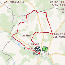
Randonnée Marche de 16,2 km à découvrir à Centre-Val de Loire, Cher, Blancafort. Cette randonnée est proposée par tracegps.
Description
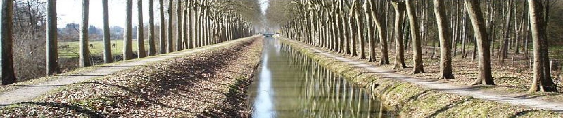
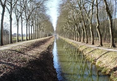
Ce tronçon isolé de 45km conserve le charme suranné des projets démesurés d’aménagements fonciers du XIXè siècle, et offre la découverte d’une Sologne sauvage et secrète, que Maurice Genevoix a si joliment contée.
Localisation
Pays :
France
Région :
Centre-Val de Loire
Département/Province :
Cher
Commune :
Blancafort
Localité :
Unknown
Départ:(Dec)
Départ:(UTM)
464620 ; 5264419 (31T) N.
Commentaires
Randonnées à proximité
![Randonnée Cheval Blancafort - Le Canal de la Sauldre - Blancafort - Photo](https://media.geolcdn.com/t/375/260/ext.jpg?maxdim=2&url=https%3A%2F%2Fservices.sitytrail.com%2FGeolivesWS%2FDownloadMedia.ashx%3FTrailID%3D316758%26Media%3D4668_1.jpg)
![Cheval Cheval](https://static1.geolcdn.com/sitytour/trail-icons/300.png)
Le Canal de la Sauldre - Blancafort
Cheval
Difficile
Blancafort,
Centre-Val de Loire,
Cher,
France
![](/images/other/stat-length.png)
16,2 km | 17,9 km-effort
3h 0min
![](https://static1.geolcdn.com/siteimages/upload/files/16400158638029165_repeat_loop_refresh_sync_direction_icon.png)
Oui
![Randonnée V.T.T. Blancafort - Le Canal de la Sauldre - Blancafort - Photo](https://media.geolcdn.com/t/375/260/ext.jpg?maxdim=2&url=https%3A%2F%2Fservices.sitytrail.com%2FGeolivesWS%2FDownloadMedia.ashx%3FTrailID%3D316757%26Media%3D4668_1.jpg)
![V.T.T. V.T.T.](https://static1.geolcdn.com/sitytour/trail-icons/202.png)
Le Canal de la Sauldre - Blancafort
V.T.T.
Moyen
Blancafort,
Centre-Val de Loire,
Cher,
France
![](/images/other/stat-length.png)
16,2 km | 17,9 km-effort
2h 0min
![](https://static1.geolcdn.com/siteimages/upload/files/16400158638029165_repeat_loop_refresh_sync_direction_icon.png)
Oui
![Randonnée Marche Blancafort - Blancafort - Photo](https://media.geolcdn.com/t/375/260/ext.jpg?maxdim=2&url=https%3A%2F%2Fstatic1.geolcdn.com%2Fsiteimages%2Fupload%2Ffiles%2F1553511878bg_sport_marche.png)
![Marche Marche](https://static1.geolcdn.com/sitytour/trail-icons/101.png)
Blancafort
Marche
Très facile
Blancafort,
Centre-Val de Loire,
Cher,
France
![](/images/other/stat-length.png)
9,7 km | 10,6 km-effort
2h 22min
![](https://static1.geolcdn.com/siteimages/upload/files/16400158638029165_repeat_loop_refresh_sync_direction_icon.png)
Oui
![Randonnée Marche Concressault - Ballade dans la campagne du Cher - Photo](https://media.geolcdn.com/t/375/260/ext.jpg?maxdim=2&url=https%3A%2F%2Fstatic1.geolcdn.com%2Fsiteimages%2Fupload%2Ffiles%2F1553511878bg_sport_marche.png)
![Marche Marche](https://static1.geolcdn.com/sitytour/trail-icons/101.png)
Ballade dans la campagne du Cher
Marche
Très facile
Concressault,
Centre-Val de Loire,
Cher,
France
![](/images/other/stat-length.png)
8,9 km | 10,5 km-effort
2h 33min
![](https://static1.geolcdn.com/siteimages/upload/files/16400158638029165_repeat_loop_refresh_sync_direction_icon.png)
Oui
![Randonnée Marche Blancafort - BMF-160903.2 - Aubigny-Blancafort - Photo](https://media.geolcdn.com/t/375/260/ext.jpg?maxdim=2&url=https%3A%2F%2Fservices.sitytrail.com%2FGeolivesWS%2FDownloadMedia.ashx%3FTrailID%3D627865%26Media%3Dfix__20160903162736.jpg)
![Marche Marche](https://static1.geolcdn.com/sitytour/trail-icons/101.png)
BMF-160903.2 - Aubigny-Blancafort
Marche
Très facile
Blancafort,
Centre-Val de Loire,
Cher,
France
![](/images/other/stat-length.png)
2,6 km | 2,9 km-effort
50min
![](https://static1.geolcdn.com/siteimages/upload/files/16400158638029165_repeat_loop_refresh_sync_direction_icon.png)
Oui
![Randonnée Marche Blancafort - Blancafort 25 04 2021 - Photo](https://media.geolcdn.com/t/375/260/ext.jpg?maxdim=2&url=https%3A%2F%2Fstatic1.geolcdn.com%2Fsiteimages%2Fupload%2Ffiles%2F1553511878bg_sport_marche.png)
![Marche Marche](https://static1.geolcdn.com/sitytour/trail-icons/101.png)
Blancafort 25 04 2021
Marche
Facile
Blancafort,
Centre-Val de Loire,
Cher,
France
![](/images/other/stat-length.png)
10,8 km | 12 km-effort
2h 25min
![](https://static1.geolcdn.com/siteimages/upload/files/16400158638029165_repeat_loop_refresh_sync_direction_icon.png)
Oui
![Randonnée Marche Blancafort - aubigny - Photo](https://media.geolcdn.com/t/375/260/ext.jpg?maxdim=2&url=https%3A%2F%2Fstatic1.geolcdn.com%2Fsiteimages%2Fupload%2Ffiles%2F1553511878bg_sport_marche.png)
![Marche Marche](https://static1.geolcdn.com/sitytour/trail-icons/101.png)
aubigny
Marche
Très facile
Blancafort,
Centre-Val de Loire,
Cher,
France
![](/images/other/stat-length.png)
28 km | 32 km-effort
7h 4min
![](https://static1.geolcdn.com/siteimages/upload/files/16400158638029165_repeat_loop_refresh_sync_direction_icon.png)
Non
très belle randonnée avec beaucoup de chemin bordé de haies