![](/images/other/stat-length.png)
![Randonnée Marche Gazeran - Le sentier d'Orphin de Gazeran à Rambouillet - Photo](https://media.geolcdn.com/t/1900/400/ext.pjpeg?maxdim=2&url=https%3A%2F%2Fservices.sitytrail.com%2FGeolivesWS%2FDownloadMedia.ashx%3FTrailID%3D316685%26Media%3D3816_1.jpg)
Le sentier d'Orphin de Gazeran à Rambouillet
tracegps
Utilisateur
![Longueur](/images/other/stat-length.png)
Longueur
25 km
![Altitude max](https://static1.geolcdn.com/siteimages/upload/files/1508320355ic_sort_altitude_max_24dp.png)
Altitude max
172 m
![Dénivelé positif](https://static1.geolcdn.com/siteimages/upload/files/1508320355ic_sort_den_pos_24dp.png)
Dénivelé positif
264 m
![Km-Effort](/images/other/stat-length.png)
Km-Effort
29 km
![Altitude min](https://static1.geolcdn.com/siteimages/upload/files/1508320355ic_sort_altitude_min_24dp.png)
Altitude min
130 m
![Dénivelé négatif](https://static1.geolcdn.com/siteimages/upload/files/1508320355ic_sort_den_neg_24dp.png)
Dénivelé négatif
268 m
![Boucle](https://static1.geolcdn.com/siteimages/upload/files/16400158638029165_repeat_loop_refresh_sync_direction_icon.png)
Boucle
Non
Date de création :
2014-12-10 00:00:00.0
Dernière modification :
2014-12-10 00:00:00.0
![Marche](https://static1.geolcdn.com/sitytour/trail-icons/101.png)
6h15
Difficulté : Difficile
![Scannez ce code QR pour ouvrir la randonnée dans l'application SityTrail](https://capi.geolives.com/qq0zvz2zws4bq2lad0pu/sitytour/trails/316685/qr.png?size=200)
Application GPS de randonnée GRATUITE
À propos
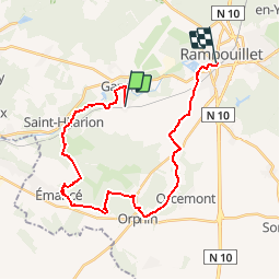
Randonnée Marche de 25 km à découvrir à Île-de-France, Yvelines, Gazeran. Cette randonnée est proposée par tracegps.
Description
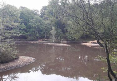
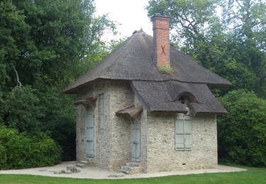
De Gazeran à Rambouillet, une randonnée champêtre où les sentiers et les bois jouent à cache-cache. Passage au Parc de Rambouillet.
Localisation
Pays :
France
Région :
Île-de-France
Département/Province :
Yvelines
Commune :
Gazeran
Localité :
Unknown
Départ:(Dec)
Départ:(UTM)
409555 ; 5386614 (31U) N.
Commentaires
Randonnées à proximité
![Randonnée V.T.T. Rambouillet - _Les étangs de Hollande - Photo](https://media.geolcdn.com/t/375/260/ext.jpg?maxdim=2&url=https%3A%2F%2Fservices.sitytrail.com%2FGeolivesWS%2FDownloadMedia.ashx%3FTrailID%3D800162%26Media%3D52612154-f602-4842-8786-57578e341d5c.jpg)
![V.T.T. V.T.T.](https://static1.geolcdn.com/sitytour/trail-icons/202.png)
_Les étangs de Hollande
V.T.T.
Moyen
(2)
Rambouillet,
Île-de-France,
Yvelines,
France
![](/images/other/stat-length.png)
29 km | 33 km-effort
2h 9min
![](https://static1.geolcdn.com/siteimages/upload/files/16400158638029165_repeat_loop_refresh_sync_direction_icon.png)
Oui
![Randonnée A pied Rambouillet - *De Rambouillet au Perray en Yveline - Photo](https://media.geolcdn.com/t/375/260/ext.jpg?maxdim=2&url=https%3A%2F%2Fstatic1.geolcdn.com%2Fsiteimages%2Fupload%2Ffiles%2F1545311037marcheuse_200dpi.jpg)
![A pied A pied](https://static1.geolcdn.com/sitytour/trail-icons/100.png)
*De Rambouillet au Perray en Yveline
A pied
Très facile
(1)
Rambouillet,
Île-de-France,
Yvelines,
France
![](/images/other/stat-length.png)
14,2 km | 15,7 km-effort
Inconnu
![](https://static1.geolcdn.com/siteimages/upload/files/16400158638029165_repeat_loop_refresh_sync_direction_icon.png)
Non
![Randonnée Marche Gazeran - 20190714 boucle Gazeran - Photo](https://media.geolcdn.com/t/375/260/ext.jpg?maxdim=2&url=https%3A%2F%2Fstatic1.geolcdn.com%2Fsiteimages%2Fupload%2Ffiles%2F1553511878bg_sport_marche.png)
![Marche Marche](https://static1.geolcdn.com/sitytour/trail-icons/101.png)
20190714 boucle Gazeran
Marche
Très difficile
(1)
Gazeran,
Île-de-France,
Yvelines,
France
![](/images/other/stat-length.png)
25 km | 30 km-effort
6h 28min
![](https://static1.geolcdn.com/siteimages/upload/files/16400158638029165_repeat_loop_refresh_sync_direction_icon.png)
Oui
![Randonnée Marche Rambouillet - _Les fabuleux trésors du Parc de Rambouillet - Photo](https://media.geolcdn.com/t/375/260/ext.jpg?maxdim=2&url=https%3A%2F%2Fservices.sitytrail.com%2FGeolivesWS%2FDownloadMedia.ashx%3FTrailID%3D784682%26Media%3Dfa7055db-3b58-41dc-94c6-5f3ecfa2372f.JPG)
![Marche Marche](https://static1.geolcdn.com/sitytour/trail-icons/101.png)
_Les fabuleux trésors du Parc de Rambouillet
Marche
Moyen
Rambouillet,
Île-de-France,
Yvelines,
France
![](/images/other/stat-length.png)
6,8 km | 7,9 km-effort
1h 30min
![](https://static1.geolcdn.com/siteimages/upload/files/16400158638029165_repeat_loop_refresh_sync_direction_icon.png)
Oui
![Randonnée Marche Rambouillet - Le tour du Grand paris via le GR1étape 19 - Rambouillet - Montfort l'Amaury - Photo](https://media.geolcdn.com/t/375/260/452c5d4e-6b62-4fbb-82fe-9f719960127e.jpg&format=jpg&maxdim=2)
![Marche Marche](https://static1.geolcdn.com/sitytour/trail-icons/101.png)
Le tour du Grand paris via le GR1étape 19 - Rambouillet - Montfort l'Amaury
Marche
Difficile
Rambouillet,
Île-de-France,
Yvelines,
France
![](/images/other/stat-length.png)
38 km | 45 km-effort
6h 48min
![](https://static1.geolcdn.com/siteimages/upload/files/16400158638029165_repeat_loop_refresh_sync_direction_icon.png)
Non
![Randonnée Marche Rambouillet - Promenade ludique dans le Parc de Rambouillet - Photo](https://media.geolcdn.com/t/375/260/5bfcca4f-2bd2-4018-9086-9ddfa055f479.jpg&format=jpg&maxdim=2)
![Marche Marche](https://static1.geolcdn.com/sitytour/trail-icons/101.png)
Promenade ludique dans le Parc de Rambouillet
Marche
Facile
Rambouillet,
Île-de-France,
Yvelines,
France
![](/images/other/stat-length.png)
7,7 km | 8,6 km-effort
2h 7min
![](https://static1.geolcdn.com/siteimages/upload/files/16400158638029165_repeat_loop_refresh_sync_direction_icon.png)
Oui
![Randonnée A pied Rambouillet - Rambouillet- etang de la tour - Photo](https://media.geolcdn.com/t/375/260/ext.jpg?maxdim=2&url=https%3A%2F%2Fstatic1.geolcdn.com%2Fsiteimages%2Fupload%2Ffiles%2F1545311037marcheuse_200dpi.jpg)
![A pied A pied](https://static1.geolcdn.com/sitytour/trail-icons/100.png)
Rambouillet- etang de la tour
A pied
Facile
(1)
Rambouillet,
Île-de-France,
Yvelines,
France
![](/images/other/stat-length.png)
14,5 km | 16 km-effort
Inconnu
![](https://static1.geolcdn.com/siteimages/upload/files/16400158638029165_repeat_loop_refresh_sync_direction_icon.png)
Oui
![Randonnée Marche Rambouillet - Rambouillet Poigny la Foret - Photo](https://media.geolcdn.com/t/375/260/ext.jpg?maxdim=2&url=https%3A%2F%2Fstatic1.geolcdn.com%2Fsiteimages%2Fupload%2Ffiles%2F1553511878bg_sport_marche.png)
![Marche Marche](https://static1.geolcdn.com/sitytour/trail-icons/101.png)
Rambouillet Poigny la Foret
Marche
Facile
(1)
Rambouillet,
Île-de-France,
Yvelines,
France
![](/images/other/stat-length.png)
24 km | 28 km-effort
6h 2min
![](https://static1.geolcdn.com/siteimages/upload/files/16400158638029165_repeat_loop_refresh_sync_direction_icon.png)
Oui
![Randonnée Marche Gazeran - adal 20160315 RAMBOUILLET - Photo](https://media.geolcdn.com/t/375/260/ext.jpg?maxdim=2&url=https%3A%2F%2Fstatic1.geolcdn.com%2Fsiteimages%2Fupload%2Ffiles%2F1553511878bg_sport_marche.png)
![Marche Marche](https://static1.geolcdn.com/sitytour/trail-icons/101.png)
adal 20160315 RAMBOUILLET
Marche
Moyen
(1)
Gazeran,
Île-de-France,
Yvelines,
France
![](/images/other/stat-length.png)
18 km | 20 km-effort
4h 25min
![](https://static1.geolcdn.com/siteimages/upload/files/16400158638029165_repeat_loop_refresh_sync_direction_icon.png)
Oui