![](/images/other/stat-length.png)
![Randonnée A pied Peyreleau - Peyreleau : La corniche du causse Noir - Photo](https://media.geolcdn.com/t/1900/400/ext.pjpeg?maxdim=2&url=https%3A%2F%2Fstatic1.geolcdn.com%2Fsiteimages%2Fupload%2Ffiles%2F1545311037marcheuse_200dpi.jpg)
Peyreleau : La corniche du causse Noir
tercla
Utilisateur
![Longueur](/images/other/stat-length.png)
Longueur
13,5 km
![Altitude max](https://static1.geolcdn.com/siteimages/upload/files/1508320355ic_sort_altitude_max_24dp.png)
Altitude max
902 m
![Dénivelé positif](https://static1.geolcdn.com/siteimages/upload/files/1508320355ic_sort_den_pos_24dp.png)
Dénivelé positif
721 m
![Km-Effort](/images/other/stat-length.png)
Km-Effort
23 km
![Altitude min](https://static1.geolcdn.com/siteimages/upload/files/1508320355ic_sort_altitude_min_24dp.png)
Altitude min
404 m
![Dénivelé négatif](https://static1.geolcdn.com/siteimages/upload/files/1508320355ic_sort_den_neg_24dp.png)
Dénivelé négatif
715 m
![Boucle](https://static1.geolcdn.com/siteimages/upload/files/16400158638029165_repeat_loop_refresh_sync_direction_icon.png)
Boucle
Oui
Date de création :
2022-03-13 19:30:43.044
Dernière modification :
2022-03-13 19:37:10.113
![A pied](https://static1.geolcdn.com/sitytour/trail-icons/100.png)
5h14
Difficulté : Moyen
![Scannez ce code QR pour ouvrir la randonnée dans l'application SityTrail](https://capi.geolives.com/qq0zvz2zws4bq2lad0pu/sitytour/trails/3166024/qr.png?size=200)
Application GPS de randonnée GRATUITE
À propos
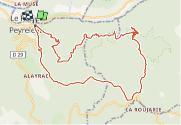
Randonnée A pied de 13,5 km à découvrir à Occitanie, Aveyron, Peyreleau. Cette randonnée est proposée par tercla.
Description
Dans Le Rozier, prendre direction Peyreleau, traverser le pont sur la Jonte et 100 mètres après, prendre à gauche une toute petite route sans aucune indication. Parking en bas de la descente, au niveau du panneau de rando ou alors un peu plus loin.
Localisation
Pays :
France
Région :
Occitanie
Département/Province :
Aveyron
Commune :
Peyreleau
Localité :
Unknown
Départ:(Dec)
Départ:(UTM)
516866 ; 4892878 (31T) N.
Commentaires
Randonnées à proximité
![Randonnée Marche Mostuéjouls - Cirque de Saint Marcellin - Mostuéjouls - Liaucous - Photo](https://media.geolcdn.com/t/375/260/ext.jpg?maxdim=2&url=https%3A%2F%2Fservices.sitytrail.com%2FGeolivesWS%2FDownloadMedia.ashx%3FTrailID%3D173134%26Media%3D14690_6.jpg)
![Marche Marche](https://static1.geolcdn.com/sitytour/trail-icons/101.png)
Cirque de Saint Marcellin - Mostuéjouls - Liaucous
Marche
Moyen
(1)
Mostuéjouls,
Occitanie,
Aveyron,
France
![](/images/other/stat-length.png)
15,4 km | 24 km-effort
5h 0min
![](https://static1.geolcdn.com/siteimages/upload/files/16400158638029165_repeat_loop_refresh_sync_direction_icon.png)
Oui
![Randonnée Marche Le Rozier - Causse et gorges au pays des vautours - Photo](https://media.geolcdn.com/t/375/260/ext.jpg?maxdim=2&url=https%3A%2F%2Fmedia.geolcdn.com%2Ff%2Fcab4842f-73f8-42f5-b236-9c9a4da22964.jpg)
![Marche Marche](https://static1.geolcdn.com/sitytour/trail-icons/101.png)
Causse et gorges au pays des vautours
Marche
Difficile
Le Rozier,
Occitanie,
Lozère,
France
![](/images/other/stat-length.png)
27 km | 40 km-effort
7h 48min
![](https://static1.geolcdn.com/siteimages/upload/files/16400158638029165_repeat_loop_refresh_sync_direction_icon.png)
Non
![Randonnée Marche Saint-Pierre-des-Tripiers - Cassagnes crête vallée Jonte et Tarn 12,2 km - Photo](https://media.geolcdn.com/t/375/260/ext.jpg?maxdim=2&url=https%3A%2F%2Fmedia.geolcdn.com%2Ff%2F9473c7ff-c94b-41a9-84a9-d12f53c1c0cb.jpg)
![Marche Marche](https://static1.geolcdn.com/sitytour/trail-icons/101.png)
Cassagnes crête vallée Jonte et Tarn 12,2 km
Marche
Moyen
Saint-Pierre-des-Tripiers,
Occitanie,
Lozère,
France
![](/images/other/stat-length.png)
12,6 km | 20 km-effort
5h 38min
![](https://static1.geolcdn.com/siteimages/upload/files/16400158638029165_repeat_loop_refresh_sync_direction_icon.png)
Non
![Randonnée Marche Veyreau - J3 St Jean des Balmes Ermitage St Michel - Photo](https://media.geolcdn.com/t/375/260/ext.jpg?maxdim=2&url=https%3A%2F%2Fstatic1.geolcdn.com%2Fsiteimages%2Fupload%2Ffiles%2F1553511878bg_sport_marche.png)
![Marche Marche](https://static1.geolcdn.com/sitytour/trail-icons/101.png)
J3 St Jean des Balmes Ermitage St Michel
Marche
Facile
(2)
Veyreau,
Occitanie,
Aveyron,
France
![](/images/other/stat-length.png)
9,6 km | 13,9 km-effort
3h 18min
![](https://static1.geolcdn.com/siteimages/upload/files/16400158638029165_repeat_loop_refresh_sync_direction_icon.png)
Oui
![Randonnée Marche Saint-Pierre-des-Tripiers - Les corniches du Méjean - Photo](https://media.geolcdn.com/t/375/260/ext.jpg?maxdim=2&url=https%3A%2F%2Fstatic1.geolcdn.com%2Fsiteimages%2Fupload%2Ffiles%2F1553511878bg_sport_marche.png)
![Marche Marche](https://static1.geolcdn.com/sitytour/trail-icons/101.png)
Les corniches du Méjean
Marche
Moyen
(3)
Saint-Pierre-des-Tripiers,
Occitanie,
Lozère,
France
![](/images/other/stat-length.png)
6 km | 9,5 km-effort
2h 31min
![](https://static1.geolcdn.com/siteimages/upload/files/16400158638029165_repeat_loop_refresh_sync_direction_icon.png)
Oui
![Randonnée Marche Saint-Pierre-des-Tripiers - LL34-Corniches du Méjean - Photo](https://media.geolcdn.com/t/375/260/ext.jpg?maxdim=2&url=https%3A%2F%2Fstatic1.geolcdn.com%2Fsiteimages%2Fupload%2Ffiles%2F1553511878bg_sport_marche.png)
![Marche Marche](https://static1.geolcdn.com/sitytour/trail-icons/101.png)
LL34-Corniches du Méjean
Marche
Difficile
(1)
Saint-Pierre-des-Tripiers,
Occitanie,
Lozère,
France
![](/images/other/stat-length.png)
12,1 km | 25 km-effort
4h 51min
![](https://static1.geolcdn.com/siteimages/upload/files/16400158638029165_repeat_loop_refresh_sync_direction_icon.png)
Oui
![Randonnée Marche Saint-Pierre-des-Tripiers - vautour - Photo](https://media.geolcdn.com/t/375/260/ext.jpg?maxdim=2&url=https%3A%2F%2Fstatic1.geolcdn.com%2Fsiteimages%2Fupload%2Ffiles%2F1553511878bg_sport_marche.png)
![Marche Marche](https://static1.geolcdn.com/sitytour/trail-icons/101.png)
vautour
Marche
Moyen
(1)
Saint-Pierre-des-Tripiers,
Occitanie,
Lozère,
France
![](/images/other/stat-length.png)
7,1 km | 12,3 km-effort
2h 59min
![](https://static1.geolcdn.com/siteimages/upload/files/16400158638029165_repeat_loop_refresh_sync_direction_icon.png)
Oui
![Randonnée Marche Le Rozier - Sur Les Hauteurs De Peyreleau - Photo](https://media.geolcdn.com/t/375/260/ext.jpg?maxdim=2&url=https%3A%2F%2Fstatic1.geolcdn.com%2Fsiteimages%2Fupload%2Ffiles%2F1553511878bg_sport_marche.png)
![Marche Marche](https://static1.geolcdn.com/sitytour/trail-icons/101.png)
Sur Les Hauteurs De Peyreleau
Marche
Difficile
(2)
Le Rozier,
Occitanie,
Lozère,
France
![](/images/other/stat-length.png)
10,4 km | 18,2 km-effort
4h 0min
![](https://static1.geolcdn.com/siteimages/upload/files/16400158638029165_repeat_loop_refresh_sync_direction_icon.png)
Oui
![Randonnée Marche Peyreleau - Le 815 - Peyreleau - Photo](https://media.geolcdn.com/t/375/260/ext.jpg?maxdim=2&url=https%3A%2F%2Fstatic1.geolcdn.com%2Fsiteimages%2Fupload%2Ffiles%2F1553511878bg_sport_marche.png)
![Marche Marche](https://static1.geolcdn.com/sitytour/trail-icons/101.png)
Le 815 - Peyreleau
Marche
Facile
(1)
Peyreleau,
Occitanie,
Aveyron,
France
![](/images/other/stat-length.png)
5,5 km | 10,5 km-effort
2h 0min
![](https://static1.geolcdn.com/siteimages/upload/files/16400158638029165_repeat_loop_refresh_sync_direction_icon.png)
Oui