![](/images/other/stat-length.png)
![Randonnée Marche Flirey - FLIREY - LES VIGNOTTES - Photo](https://media.geolcdn.com/t/1900/400/de47ed9d-65ac-480e-bd61-08d60d3088fd.jpg&format=pjpeg&maxdim=2)
FLIREY - LES VIGNOTTES
jean-marie.parachini
Utilisateur
![Longueur](/images/other/stat-length.png)
Longueur
11,5 km
![Altitude max](https://static1.geolcdn.com/siteimages/upload/files/1508320355ic_sort_altitude_max_24dp.png)
Altitude max
314 m
![Dénivelé positif](https://static1.geolcdn.com/siteimages/upload/files/1508320355ic_sort_den_pos_24dp.png)
Dénivelé positif
141 m
![Km-Effort](/images/other/stat-length.png)
Km-Effort
13,3 km
![Altitude min](https://static1.geolcdn.com/siteimages/upload/files/1508320355ic_sort_altitude_min_24dp.png)
Altitude min
246 m
![Dénivelé négatif](https://static1.geolcdn.com/siteimages/upload/files/1508320355ic_sort_den_neg_24dp.png)
Dénivelé négatif
141 m
![Boucle](https://static1.geolcdn.com/siteimages/upload/files/16400158638029165_repeat_loop_refresh_sync_direction_icon.png)
Boucle
Oui
Date de création :
2022-03-08 12:33:08.221
Dernière modification :
2022-03-08 17:31:44.856
![Marche](https://static1.geolcdn.com/sitytour/trail-icons/101.png)
4h40
Difficulté : Facile
![Scannez ce code QR pour ouvrir la randonnée dans l'application SityTrail](https://capi.geolives.com/qq0zvz2zws4bq2lad0pu/sitytour/trails/3159969/qr.png?size=200)
Application GPS de randonnée GRATUITE
À propos
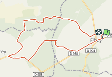
Randonnée Marche de 11,5 km à découvrir à Grand Est, Meurthe-et-Moselle, Flirey. Cette randonnée est proposée par jean-marie.parachini.
Description
Parcours au départ des ruines de l'ancienne église de Flirey détruite pendant la 1ère guerre mondiale puis passage par les tranchées allemandes de Saint Baussant.
Retour par les abords de Seicheprey et retour au point de départ.
Localisation
Pays :
France
Région :
Grand Est
Département/Province :
Meurthe-et-Moselle
Commune :
Flirey
Localité :
Unknown
Départ:(Dec)
Départ:(UTM)
709022 ; 5417564 (31U) N.
Commentaires
Randonnées à proximité
![Randonnée Vélo Mandres-aux-Quatre-Tours - La forêt de la Reine et ses mystères - Circuit n° 8 - Photo](https://media.geolcdn.com/t/375/260/ext.jpg?maxdim=2&url=https%3A%2F%2Fservices.sitytrail.com%2FGeolivesWS%2FDownloadMedia.ashx%3FTrailID%3D111708%26Media%3D8016_5.jpg)
![Vélo Vélo](https://static1.geolcdn.com/sitytour/trail-icons/200.png)
La forêt de la Reine et ses mystères - Circuit n° 8
Vélo
Difficile
Mandres-aux-Quatre-Tours,
Grand Est,
Meurthe-et-Moselle,
France
![](/images/other/stat-length.png)
50 km | 56 km-effort
3h 30min
![](https://static1.geolcdn.com/siteimages/upload/files/16400158638029165_repeat_loop_refresh_sync_direction_icon.png)
Oui
![Randonnée Marche Flirey - Flirey circuit des Vignottes - Photo](https://media.geolcdn.com/t/375/260/eb8d6a7e-130d-4b39-b5b1-4d3fceadb7ca.jpg&format=jpg&maxdim=2)
![Marche Marche](https://static1.geolcdn.com/sitytour/trail-icons/101.png)
Flirey circuit des Vignottes
Marche
Moyen
Flirey,
Grand Est,
Meurthe-et-Moselle,
France
![](/images/other/stat-length.png)
11,5 km | 13,4 km-effort
4h 43min
![](https://static1.geolcdn.com/siteimages/upload/files/16400158638029165_repeat_loop_refresh_sync_direction_icon.png)
Oui
![Randonnée Vélo électrique Lironville - lironville madine - Photo](https://media.geolcdn.com/t/375/260/ext.jpg?maxdim=2&url=https%3A%2F%2Fstatic1.geolcdn.com%2Fsiteimages%2Fupload%2Ffiles%2F1524743154velo.jpg)
![Vélo électrique Vélo électrique](https://static1.geolcdn.com/sitytour/trail-icons/205.png)
lironville madine
Vélo électrique
Très facile
Lironville,
Grand Est,
Meurthe-et-Moselle,
France
![](/images/other/stat-length.png)
55 km | 64 km-effort
3h 12min
![](https://static1.geolcdn.com/siteimages/upload/files/16400158638029165_repeat_loop_refresh_sync_direction_icon.png)
Non
![Randonnée Marche Manonville - 8/8/32 Manon Ille petite Suisse lorrainepluie - Photo](https://media.geolcdn.com/t/375/260/ext.jpg?maxdim=2&url=https%3A%2F%2Fstatic1.geolcdn.com%2Fsiteimages%2Fupload%2Ffiles%2F1553511878bg_sport_marche.png)
![Marche Marche](https://static1.geolcdn.com/sitytour/trail-icons/101.png)
8/8/32 Manon Ille petite Suisse lorrainepluie
Marche
Moyen
Manonville,
Grand Est,
Meurthe-et-Moselle,
France
![](/images/other/stat-length.png)
10,5 km | 12,8 km-effort
3h 21min
![](https://static1.geolcdn.com/siteimages/upload/files/16400158638029165_repeat_loop_refresh_sync_direction_icon.png)
Oui
![Randonnée V.T.T. Lironville - Lironville domevre - Photo](https://media.geolcdn.com/t/375/260/ext.jpg?maxdim=2&url=https%3A%2F%2Fstatic1.geolcdn.com%2Fsiteimages%2Fupload%2Ffiles%2F1524743154velo.jpg)
![V.T.T. V.T.T.](https://static1.geolcdn.com/sitytour/trail-icons/202.png)
Lironville domevre
V.T.T.
Facile
Lironville,
Grand Est,
Meurthe-et-Moselle,
France
![](/images/other/stat-length.png)
25 km | 30 km-effort
2h 19min
![](https://static1.geolcdn.com/siteimages/upload/files/16400158638029165_repeat_loop_refresh_sync_direction_icon.png)
Oui
![Randonnée Marche Flirey - mort marre - Photo](https://media.geolcdn.com/t/375/260/ext.jpg?maxdim=2&url=https%3A%2F%2Fstatic1.geolcdn.com%2Fsiteimages%2Fupload%2Ffiles%2F1553511878bg_sport_marche.png)
![Marche Marche](https://static1.geolcdn.com/sitytour/trail-icons/101.png)
mort marre
Marche
Très facile
Flirey,
Grand Est,
Meurthe-et-Moselle,
France
![](/images/other/stat-length.png)
6,6 km | 7,9 km-effort
1h 34min
![](https://static1.geolcdn.com/siteimages/upload/files/16400158638029165_repeat_loop_refresh_sync_direction_icon.png)
Non
![Randonnée V.T.T. Mandres-aux-Quatre-Tours - forêt de la reine - Photo](https://media.geolcdn.com/t/375/260/ext.jpg?maxdim=2&url=https%3A%2F%2Fstatic1.geolcdn.com%2Fsiteimages%2Fupload%2Ffiles%2F1524743154velo.jpg)
![V.T.T. V.T.T.](https://static1.geolcdn.com/sitytour/trail-icons/202.png)
forêt de la reine
V.T.T.
Très facile
Mandres-aux-Quatre-Tours,
Grand Est,
Meurthe-et-Moselle,
France
![](/images/other/stat-length.png)
30 km | 33 km-effort
2h 51min
![](https://static1.geolcdn.com/siteimages/upload/files/16400158638029165_repeat_loop_refresh_sync_direction_icon.png)
Oui
![Randonnée V.T.T. Seicheprey - Secheprey - les paroches - Photo](https://media.geolcdn.com/t/375/260/ext.jpg?maxdim=2&url=https%3A%2F%2Fstatic1.geolcdn.com%2Fsiteimages%2Fupload%2Ffiles%2F1524743154velo.jpg)
![V.T.T. V.T.T.](https://static1.geolcdn.com/sitytour/trail-icons/202.png)
Secheprey - les paroches
V.T.T.
Difficile
Seicheprey,
Grand Est,
Meurthe-et-Moselle,
France
![](/images/other/stat-length.png)
32 km | 38 km-effort
2h 38min
![](https://static1.geolcdn.com/siteimages/upload/files/16400158638029165_repeat_loop_refresh_sync_direction_icon.png)
Non
![Randonnée V.T.T. Limey-Remenauville - mussi5 - Photo](https://media.geolcdn.com/t/375/260/ext.jpg?maxdim=2&url=https%3A%2F%2Fstatic1.geolcdn.com%2Fsiteimages%2Fupload%2Ffiles%2F1524743154velo.jpg)
![V.T.T. V.T.T.](https://static1.geolcdn.com/sitytour/trail-icons/202.png)
mussi5
V.T.T.
Moyen
Limey-Remenauville,
Grand Est,
Meurthe-et-Moselle,
France
![](/images/other/stat-length.png)
21 km | 26 km-effort
2h 3min
![](https://static1.geolcdn.com/siteimages/upload/files/16400158638029165_repeat_loop_refresh_sync_direction_icon.png)
Non