![](/images/other/stat-length.png)
![Randonnée Marche Lokeren - Anders Reizen 2021 Eksaarde - Moervaart wandeling - Photo](https://media.geolcdn.com/t/1900/400/ee3c04a5-5954-4537-bea7-1b13a127d945.jpg&format=pjpeg&maxdim=2)
Anders Reizen 2021 Eksaarde - Moervaart wandeling
Geert H.
Utilisateur
![Longueur](/images/other/stat-length.png)
Longueur
17,5 km
![Altitude max](https://static1.geolcdn.com/siteimages/upload/files/1508320355ic_sort_altitude_max_24dp.png)
Altitude max
12 m
![Dénivelé positif](https://static1.geolcdn.com/siteimages/upload/files/1508320355ic_sort_den_pos_24dp.png)
Dénivelé positif
81 m
![Km-Effort](/images/other/stat-length.png)
Km-Effort
18,6 km
![Altitude min](https://static1.geolcdn.com/siteimages/upload/files/1508320355ic_sort_altitude_min_24dp.png)
Altitude min
-2 m
![Dénivelé négatif](https://static1.geolcdn.com/siteimages/upload/files/1508320355ic_sort_den_neg_24dp.png)
Dénivelé négatif
82 m
![Boucle](https://static1.geolcdn.com/siteimages/upload/files/16400158638029165_repeat_loop_refresh_sync_direction_icon.png)
Boucle
Oui
Date de création :
2022-03-06 17:29:50.345
Dernière modification :
2022-03-07 17:09:38.382
![Marche](https://static1.geolcdn.com/sitytour/trail-icons/101.png)
4h13
Difficulté : Difficile
![Scannez ce code QR pour ouvrir la randonnée dans l'application SityTrail](https://capi.geolives.com/qq0zvz2zws4bq2lad0pu/sitytour/trails/3157548/qr.png?size=200)
Application GPS de randonnée GRATUITE
À propos
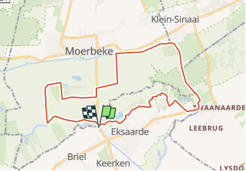
Randonnée Marche de 17,5 km à découvrir à Flandre, Flandre orientale, Lokeren. Cette randonnée est proposée par Geert H..
Description
Via Eksaarde via het reservaatproject 'De Linie'. Dan vervolgens via de Moervaart met zijn pittoreske bruggtjes richting Moerbeke, om terug te keren via de Moerbeekse meersen terug naar Eksaarde.
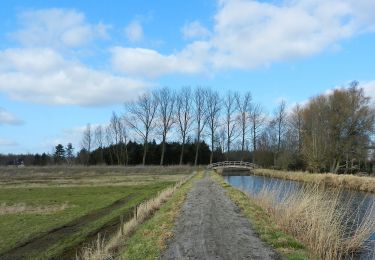
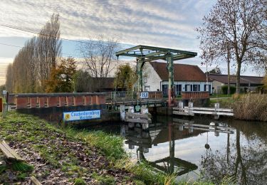
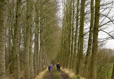
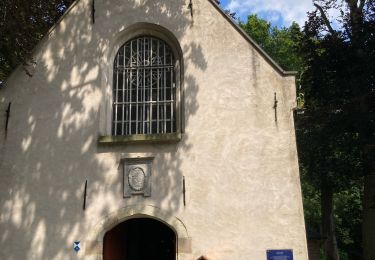
Localisation
Pays :
Belgique
Région :
Flandre
Département/Province :
Flandre orientale
Commune :
Lokeren
Localité :
Unknown
Départ:(Dec)
Départ:(UTM)
566450 ; 5666938 (31U) N.
Commentaires
Randonnées à proximité
![Vélo électrique Vélo électrique](https://static1.geolcdn.com/sitytour/trail-icons/205.png)
fietstocht ten zuiden van wachtebeke 47.8 km
Vélo électrique
Très facile
(1)
Wachtebeke,
Flandre,
Flandre orientale,
Belgique
![](/images/other/stat-length.png)
48 km | 51 km-effort
Inconnu
![](https://static1.geolcdn.com/siteimages/upload/files/16400158638029165_repeat_loop_refresh_sync_direction_icon.png)
Oui
![Randonnée A pied Lokeren - Liniewegelroute - Photo](https://media.geolcdn.com/t/375/260/62ae4cc3-6e72-4c51-bc3b-95bdff6e887b.jpeg&format=jpg&maxdim=2)
![A pied A pied](https://static1.geolcdn.com/sitytour/trail-icons/100.png)
Liniewegelroute
A pied
Facile
Lokeren,
Flandre,
Flandre orientale,
Belgique
![](/images/other/stat-length.png)
8,4 km | 9 km-effort
2h 2min
![](https://static1.geolcdn.com/siteimages/upload/files/16400158638029165_repeat_loop_refresh_sync_direction_icon.png)
Oui
![Randonnée Marche Stekene - Wullebos - Klein Sinaai (6km) (StepAway.be) - Photo](https://media.geolcdn.com/t/375/260/ext.jpg?maxdim=2&url=https%3A%2F%2Fstatic1.geolcdn.com%2Fsiteimages%2Fupload%2Ffiles%2F1553511878bg_sport_marche.png)
![Marche Marche](https://static1.geolcdn.com/sitytour/trail-icons/101.png)
Wullebos - Klein Sinaai (6km) (StepAway.be)
Marche
Facile
(1)
Stekene,
Flandre,
Flandre orientale,
Belgique
![](/images/other/stat-length.png)
5,9 km | 6,5 km-effort
1h 26min
![](https://static1.geolcdn.com/siteimages/upload/files/16400158638029165_repeat_loop_refresh_sync_direction_icon.png)
Oui
![Randonnée Marche Lokeren - DAKNAM Durmeland Lokeren - 14 km RT - Photo](https://media.geolcdn.com/t/375/260/ext.jpg?maxdim=2&url=https%3A%2F%2Fstatic1.geolcdn.com%2Fsiteimages%2Fupload%2Ffiles%2F1553511878bg_sport_marche.png)
![Marche Marche](https://static1.geolcdn.com/sitytour/trail-icons/101.png)
DAKNAM Durmeland Lokeren - 14 km RT
Marche
Très facile
(1)
Lokeren,
Flandre,
Flandre orientale,
Belgique
![](/images/other/stat-length.png)
13,7 km | 14,6 km-effort
Inconnu
![](https://static1.geolcdn.com/siteimages/upload/files/16400158638029165_repeat_loop_refresh_sync_direction_icon.png)
Oui
![Randonnée Marche Moerbeke - Moerbeke 26,5 km - Photo](https://media.geolcdn.com/t/375/260/35628380-609b-479d-af04-77325e1722d8.jpg&format=jpg&maxdim=2)
![Marche Marche](https://static1.geolcdn.com/sitytour/trail-icons/101.png)
Moerbeke 26,5 km
Marche
Moyen
Moerbeke,
Flandre,
Flandre orientale,
Belgique
![](/images/other/stat-length.png)
27 km | 28 km-effort
5h 44min
![](https://static1.geolcdn.com/siteimages/upload/files/16400158638029165_repeat_loop_refresh_sync_direction_icon.png)
Oui
![Randonnée A pied Saint-Nicolas - Fondatie van Boudeloroute - Photo](https://media.geolcdn.com/t/375/260/8e5b7271-48e9-4cd7-899b-9ae7b9cc4a80.jpeg&format=jpg&maxdim=2)
![A pied A pied](https://static1.geolcdn.com/sitytour/trail-icons/100.png)
Fondatie van Boudeloroute
A pied
Facile
Saint-Nicolas,
Flandre,
Flandre orientale,
Belgique
![](/images/other/stat-length.png)
6 km | 6,5 km-effort
1h 28min
![](https://static1.geolcdn.com/siteimages/upload/files/16400158638029165_repeat_loop_refresh_sync_direction_icon.png)
Oui
![Randonnée Marche Lokeren - liniewegel - Photo](https://media.geolcdn.com/t/375/260/ext.jpg?maxdim=2&url=https%3A%2F%2Fstatic1.geolcdn.com%2Fsiteimages%2Fupload%2Ffiles%2F1553511878bg_sport_marche.png)
![Marche Marche](https://static1.geolcdn.com/sitytour/trail-icons/101.png)
liniewegel
Marche
Très facile
(1)
Lokeren,
Flandre,
Flandre orientale,
Belgique
![](/images/other/stat-length.png)
8,4 km | 9 km-effort
Inconnu
![](https://static1.geolcdn.com/siteimages/upload/files/16400158638029165_repeat_loop_refresh_sync_direction_icon.png)
Oui
![Randonnée Vélo électrique Wachtebeke - Sterretrappers gefietst Wachtebeke - Photo](https://media.geolcdn.com/t/375/260/b966c27e-bf0d-4342-9da9-7188e9d72bea.jpg&format=jpg&maxdim=2)
![Vélo électrique Vélo électrique](https://static1.geolcdn.com/sitytour/trail-icons/205.png)
Sterretrappers gefietst Wachtebeke
Vélo électrique
Facile
Wachtebeke,
Flandre,
Flandre orientale,
Belgique
![](/images/other/stat-length.png)
51 km | 54 km-effort
4h 19min
![](https://static1.geolcdn.com/siteimages/upload/files/16400158638029165_repeat_loop_refresh_sync_direction_icon.png)
Oui
![Randonnée Marche Moerbeke - Heidebos - Photo](https://media.geolcdn.com/t/375/260/ext.jpg?maxdim=2&url=https%3A%2F%2Fservices.sitytrail.com%2FGeolivesWS%2FDownloadMedia.ashx%3FTrailID%3D263941%26Media%3D)
![Marche Marche](https://static1.geolcdn.com/sitytour/trail-icons/101.png)
Heidebos
Marche
Facile
Moerbeke,
Flandre,
Flandre orientale,
Belgique
![](/images/other/stat-length.png)
6,2 km | 6,9 km-effort
1h 31min
![](https://static1.geolcdn.com/siteimages/upload/files/16400158638029165_repeat_loop_refresh_sync_direction_icon.png)
Oui