![](/images/other/stat-length.png)
![Randonnée Marche Profondeville - PROFONDEVILLE ... Petite et Grande Hulle. - Photo](https://media.geolcdn.com/t/1900/400/2884a55e-78a0-4db3-b2c6-41fc1bff4bf5.jpg&format=pjpeg&maxdim=2)
PROFONDEVILLE ... Petite et Grande Hulle.
GerardBouche
Utilisateur
![Longueur](/images/other/stat-length.png)
Longueur
8,9 km
![Altitude max](https://static1.geolcdn.com/siteimages/upload/files/1508320355ic_sort_altitude_max_24dp.png)
Altitude max
219 m
![Dénivelé positif](https://static1.geolcdn.com/siteimages/upload/files/1508320355ic_sort_den_pos_24dp.png)
Dénivelé positif
240 m
![Km-Effort](/images/other/stat-length.png)
Km-Effort
12,1 km
![Altitude min](https://static1.geolcdn.com/siteimages/upload/files/1508320355ic_sort_altitude_min_24dp.png)
Altitude min
81 m
![Dénivelé négatif](https://static1.geolcdn.com/siteimages/upload/files/1508320355ic_sort_den_neg_24dp.png)
Dénivelé négatif
241 m
![Boucle](https://static1.geolcdn.com/siteimages/upload/files/16400158638029165_repeat_loop_refresh_sync_direction_icon.png)
Boucle
Oui
Date de création :
2022-02-27 13:04:39.573
Dernière modification :
2022-02-28 08:24:02.111
![Marche](https://static1.geolcdn.com/sitytour/trail-icons/101.png)
2h06
Difficulté : Facile
![Scannez ce code QR pour ouvrir la randonnée dans l'application SityTrail](https://capi.geolives.com/qq0zvz2zws4bq2lad0pu/sitytour/trails/3148456/qr.png?size=200)
Application GPS de randonnée GRATUITE
À propos
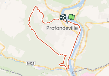
Randonnée Marche de 8,9 km à découvrir à Wallonie, Namur, Profondeville. Cette randonnée est proposée par GerardBouche.
Description
Très beau parcours depuis le Centre Culturel ... par la Petite Hulle, le centre sportif, le quartier de Roquebrune, le sentier en palier de la Grande Hulle, la rive gauche de la Meuse et les très belles petites ruelles du centre de Profondeville.
Localisation
Pays :
Belgique
Région :
Wallonie
Département/Province :
Namur
Commune :
Profondeville
Localité :
Profondeville
Départ:(Dec)
Départ:(UTM)
632995 ; 5582292 (31U) N.
Commentaires
Randonnées à proximité
![Randonnée Marche Profondeville - RL-GG-19 - Lustin - Namur - 2025-02-11 - Photo](https://media.geolcdn.com/t/375/260/88a86cfe-b235-4765-8490-790641831c6f.jpg&format=jpg&maxdim=2)
![Marche Marche](https://static1.geolcdn.com/sitytour/trail-icons/101.png)
RL-GG-19 - Lustin - Namur - 2025-02-11
Marche
Très difficile
(13)
Profondeville,
Wallonie,
Namur,
Belgique
![](/images/other/stat-length.png)
22 km | 29 km-effort
6h 30min
![](https://static1.geolcdn.com/siteimages/upload/files/16400158638029165_repeat_loop_refresh_sync_direction_icon.png)
Non
![Marche Marche](https://static1.geolcdn.com/sitytour/trail-icons/101.png)
RB-Na-21_Mont
Marche
Très difficile
(6)
Yvoir,
Wallonie,
Namur,
Belgique
![](/images/other/stat-length.png)
22 km | 30 km-effort
6h 51min
![](https://static1.geolcdn.com/siteimages/upload/files/16400158638029165_repeat_loop_refresh_sync_direction_icon.png)
Oui
![Marche Marche](https://static1.geolcdn.com/sitytour/trail-icons/101.png)
RB-Na-20_Profondeville_via-racc-2
Marche
Très difficile
(11)
Profondeville,
Wallonie,
Namur,
Belgique
![](/images/other/stat-length.png)
14,6 km | 22 km-effort
4h 53min
![](https://static1.geolcdn.com/siteimages/upload/files/16400158638029165_repeat_loop_refresh_sync_direction_icon.png)
Oui
![Marche Marche](https://static1.geolcdn.com/sitytour/trail-icons/101.png)
RB-Na-20_Profondeville
Marche
Très difficile
(16)
Profondeville,
Wallonie,
Namur,
Belgique
![](/images/other/stat-length.png)
18,5 km | 26 km-effort
5h 55min
![](https://static1.geolcdn.com/siteimages/upload/files/16400158638029165_repeat_loop_refresh_sync_direction_icon.png)
Oui
![Randonnée Marche Yvoir - RL-GG-38_Godinne_Dinant - Photo](https://media.geolcdn.com/t/375/260/4b7f8162-b405-4557-afe1-7567462c4aff.jpg&format=jpg&maxdim=2)
![Marche Marche](https://static1.geolcdn.com/sitytour/trail-icons/101.png)
RL-GG-38_Godinne_Dinant
Marche
Très difficile
(6)
Yvoir,
Wallonie,
Namur,
Belgique
![](/images/other/stat-length.png)
19,5 km | 27 km-effort
6h 13min
![](https://static1.geolcdn.com/siteimages/upload/files/16400158638029165_repeat_loop_refresh_sync_direction_icon.png)
Non
![Randonnée Marche Anhée - RF-Na-05 Annevoie, côté Jardins_Grande-boucle - Photo](https://media.geolcdn.com/t/375/260/ext.jpg?maxdim=2&url=https%3A%2F%2Fservices.sitytrail.com%2FGeolivesWS%2FDownloadMedia.ashx%3FTrailID%3D545753%26Media%3D5d973c83-4a6c-40fc-a026-25de6c754887.JPG)
![Marche Marche](https://static1.geolcdn.com/sitytour/trail-icons/101.png)
RF-Na-05 Annevoie, côté Jardins_Grande-boucle
Marche
Moyen
(11)
Anhée,
Wallonie,
Namur,
Belgique
![](/images/other/stat-length.png)
11,3 km | 14,5 km-effort
3h 6min
![](https://static1.geolcdn.com/siteimages/upload/files/16400158638029165_repeat_loop_refresh_sync_direction_icon.png)
Oui
![Randonnée Marche Anhée - RF-Na-05 Annevoie, côté Jardins_Petite-boucle - Photo](https://media.geolcdn.com/t/375/260/ext.jpg?maxdim=2&url=https%3A%2F%2Fservices.sitytrail.com%2FGeolivesWS%2FDownloadMedia.ashx%3FTrailID%3D545751%26Media%3D5d973c83-4a6c-40fc-a026-25de6c754887.JPG)
![Marche Marche](https://static1.geolcdn.com/sitytour/trail-icons/101.png)
RF-Na-05 Annevoie, côté Jardins_Petite-boucle
Marche
Facile
(7)
Anhée,
Wallonie,
Namur,
Belgique
![](/images/other/stat-length.png)
7,4 km | 10 km-effort
2h 7min
![](https://static1.geolcdn.com/siteimages/upload/files/16400158638029165_repeat_loop_refresh_sync_direction_icon.png)
Oui
![Randonnée Marche Namur - De Naninne vers Dave par les Fonds de Lustin et les Bois d'Acremont - Photo](https://media.geolcdn.com/t/375/260/ext.jpg?maxdim=2&url=https%3A%2F%2Fstatic1.geolcdn.com%2Fsiteimages%2Fupload%2Ffiles%2F1553511878bg_sport_marche.png)
![Marche Marche](https://static1.geolcdn.com/sitytour/trail-icons/101.png)
De Naninne vers Dave par les Fonds de Lustin et les Bois d'Acremont
Marche
Moyen
(5)
Namur,
Wallonie,
Namur,
Belgique
![](/images/other/stat-length.png)
19 km | 25 km-effort
5h 0min
![](https://static1.geolcdn.com/siteimages/upload/files/16400158638029165_repeat_loop_refresh_sync_direction_icon.png)
Oui
![Randonnée Marche Profondeville - Profondeville - Photo](https://media.geolcdn.com/t/375/260/f2691757-ffd7-4f68-a5e0-1d2bff857008.jpg&format=jpg&maxdim=2)
![Marche Marche](https://static1.geolcdn.com/sitytour/trail-icons/101.png)
Profondeville
Marche
Moyen
(1)
Profondeville,
Wallonie,
Namur,
Belgique
![](/images/other/stat-length.png)
16,7 km | 25 km-effort
3h 49min
![](https://static1.geolcdn.com/siteimages/upload/files/16400158638029165_repeat_loop_refresh_sync_direction_icon.png)
Oui