Randonnée Marche La Robine-sur-Galabre - Rando1063 - Photo
 Escondido
Escondido

Utilisateur

© OpenStreetMap contributors
Longueur
Longueur
23 km
Altitude max
Altitude max
1269 m
Dénivelé positif
Dénivelé positif
1428 m
Km-Effort
Km-Effort  
42 km
Altitude min
Altitude min
727 m
Dénivelé négatif
Dénivelé négatif
1430 m
Boucle
Boucle
Oui
Date de création :
2022-02-25 09:02:43.625
Dernière modification :
2022-02-25 20:22:51.944

(0 Avis)

Marche
Marche
5h56
Difficulté : Très difficile

Scannez ce code QR pour ouvrir la randonnée dans l'application SityTrail

Application GPS de randonnée GRATUITE

Logo SityTrail SityTrail

IGN / Instituts géographiques

Télécharger SityTrail sur l'App Store Télécharger SityTrail sur Google Play

Logo SityTrail SityTrail World

Le monde est à vous

Télécharger SityTrail sur l'App Store Télécharger SityTrail sur Google Play Télécharger SityTrail sur Huawei AppGallery

À propos

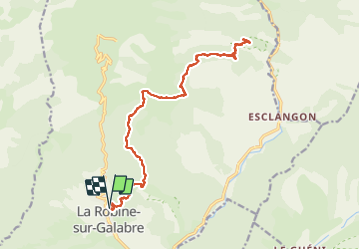
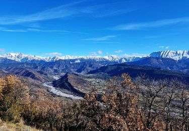
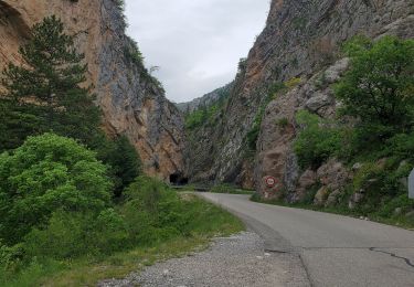
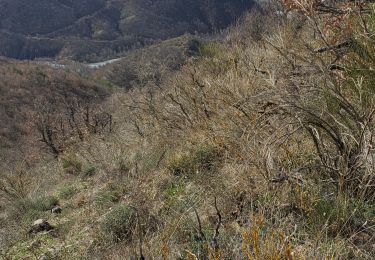
Randonnée Marche de 23 km à découvrir à Provence-Alpes-Côte d'Azur, Alpes-de-Haute-Provence, La Robine-sur-Galabre. Cette randonnée est proposée par Escondido.

Description

AR La Robine- Chapelle St Jean du Désert

Profil altimétrique

Localisation

Pays :
France
Région :
Provence-Alpes-Côte d'Azur
Département/Province :
Alpes-de-Haute-Provence
Commune :
La Robine-sur-Galabre
Localité :
Unknown
Départ:(UTM)
277598 ; 4894904 (32T) N.

Randonnées à proximité

Randonnée Marche Hautes-Duyes - geruen sentier des chamois  - Photo
Marche
GUIDE
Danielba

Marche

Très difficile
(1)
Hautes-Duyes, Provence-Alpes-Côte d'Azur, Alpes-de-Haute-Provence, France
11 km | 22 km-effort
7h 15min
Oui
Randonnée Marche Hautes-Duyes - Crête de Géruën descente sud Est - Photo
Marche
GUIDE
nadd73

Marche

Difficile
Hautes-Duyes, Provence-Alpes-Côte d'Azur, Alpes-de-Haute-Provence, France
11,6 km | 22 km-effort
5h 18min
Oui
Randonnée Marche Hautes-Duyes - sommet Geruen et son pas - Photo
Marche
GUIDE
nadd73

Marche

Difficile
Hautes-Duyes, Provence-Alpes-Côte d'Azur, Alpes-de-Haute-Provence, France
14 km | 28 km-effort
7h 6min
Oui
Randonnée Marche La Robine-sur-Galabre - LAMBERT mourre du barri  o - Photo
Marche
RobinMicheline

Marche

Très facile
(1)
La Robine-sur-Galabre, Provence-Alpes-Côte d'Azur, Alpes-de-Haute-Provence, France
12,6 km | 21 km-effort
4h 18min
Oui
Randonnée Marche La Javie - vélodrome esclangon 17kms 1049m - Photo
Marche
GUIDE
Danielba

Marche

Difficile
La Javie, Provence-Alpes-Côte d'Azur, Alpes-de-Haute-Provence, France
15,5 km | 29 km-effort
7h 28min
Oui
Randonnée Marche Marcoux - Marcoux crete de liman 950m 15kms  - Photo
Marche
GUIDE
Danielba

Marche

Moyen
Marcoux, Provence-Alpes-Côte d'Azur, Alpes-de-Haute-Provence, France
14,7 km | 25 km-effort
7h 31min
Non
Randonnée Marche La Robine-sur-Galabre - LA ROBINE . Les Pharaons Au fil de l eau o m s - Photo
Marche
RobinMicheline

Marche

Facile
(1)
La Robine-sur-Galabre, Provence-Alpes-Côte d'Azur, Alpes-de-Haute-Provence, France
8,4 km | 14,3 km-effort
3h 7min
Oui
Randonnée A pied Marcoux - La Crête de Liman - Photo
A pied
PRO

A pied

Facile
Marcoux, Provence-Alpes-Côte d'Azur, Alpes-de-Haute-Provence, France
10 km | 18,5 km-effort
4h 12min
Non
Randonnée Marche La Robine-sur-Galabre - AINAC Col S Antoine . Feissal o s  - Photo
Marche
RobinMicheline

Marche

Moyen
La Robine-sur-Galabre, Provence-Alpes-Côte d'Azur, Alpes-de-Haute-Provence, France
12,7 km | 19,3 km-effort
3h 47min
Oui


Fermer
Mes abonnements