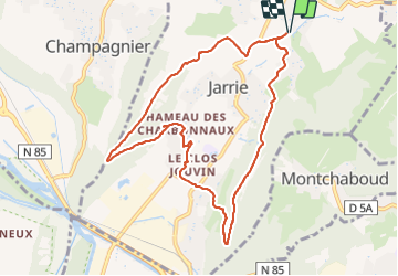
![](/images/other/stat-length.png)
![Randonnée Marche nordique Jarrie - Reconnaissance d'une MN au départ du Château de Bon Repos - Photo](https://media.geolcdn.com/t/1900/400/fb5c32af-77b4-4559-a85c-cbd0f496df1f.jpg&format=pjpeg&maxdim=2)
Reconnaissance d'une MN au départ du Château de Bon Repos
Emelle
Utilisateur
![Longueur](/images/other/stat-length.png)
![Altitude max](https://static1.geolcdn.com/siteimages/upload/files/1508320355ic_sort_altitude_max_24dp.png)
![Dénivelé positif](https://static1.geolcdn.com/siteimages/upload/files/1508320355ic_sort_den_pos_24dp.png)
![Km-Effort](/images/other/stat-length.png)
![Altitude min](https://static1.geolcdn.com/siteimages/upload/files/1508320355ic_sort_altitude_min_24dp.png)
![Dénivelé négatif](https://static1.geolcdn.com/siteimages/upload/files/1508320355ic_sort_den_neg_24dp.png)
![Boucle](https://static1.geolcdn.com/siteimages/upload/files/16400158638029165_repeat_loop_refresh_sync_direction_icon.png)
![Marche nordique](https://static1.geolcdn.com/sitytour/trail-icons/102.png)
3h31
Difficulté : Facile
![Scannez ce code QR pour ouvrir la randonnée dans l'application SityTrail](https://capi.geolives.com/qq0zvz2zws4bq2lad0pu/sitytour/trails/3144526/qr.png?size=200)
Application GPS de randonnée GRATUITE
À propos
Randonnée Marche nordique de 9,9 km à découvrir à Auvergne-Rhône-Alpes, Isère, Jarrie. Cette randonnée est proposée par Emelle.
Description
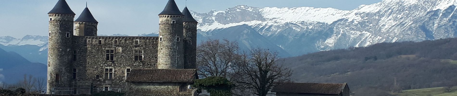
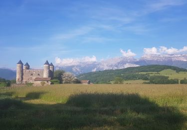
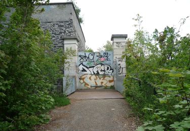
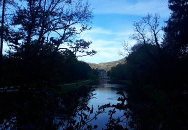
Une marche nordique qui permet de découvrir le château de Bon Repas et le Clos Jouvin avec son parc et ses arbres remarquables.
Le retour par le Saut du Moine permet de faire un circuit complet.
Une seule portion un peu raide à la descente qui doit pouvoir être contourner (à vérifier).
Localisation
Commentaires
Randonnées à proximité
![Randonnée Course à pied Vizille - Echappée Belle 2013 - Photo](https://media.geolcdn.com/t/375/260/ext.jpg?maxdim=2&url=https%3A%2F%2Fstatic1.geolcdn.com%2Fsiteimages%2Fupload%2Ffiles%2F1524743154running.jpg)
![Course à pied Course à pied](https://static1.geolcdn.com/sitytour/trail-icons/103.png)
Course à pied
![](/images/other/stat-length.png)
![](https://static1.geolcdn.com/siteimages/upload/files/16400158638029165_repeat_loop_refresh_sync_direction_icon.png)
![Randonnée Marche Champ-sur-Drac - 38 Couvent St Michel Champ / drac - Photo](https://media.geolcdn.com/t/375/260/2541c209-e2b9-4fc5-ac0c-29659bf67ee5.jpg&format=jpg&maxdim=2)
![Marche Marche](https://static1.geolcdn.com/sitytour/trail-icons/101.png)
Marche
![](/images/other/stat-length.png)
![](https://static1.geolcdn.com/siteimages/upload/files/16400158638029165_repeat_loop_refresh_sync_direction_icon.png)
![Randonnée Marche Varces-Allières-et-Risset - Les Etangs de Reymure réaménagés en 2023. - Photo](https://media.geolcdn.com/t/375/260/a9036917-cc32-4324-8d0a-4d872f501612.jpg&format=jpg&maxdim=2)
![Marche Marche](https://static1.geolcdn.com/sitytour/trail-icons/101.png)
Marche
![](/images/other/stat-length.png)
![](https://static1.geolcdn.com/siteimages/upload/files/16400158638029165_repeat_loop_refresh_sync_direction_icon.png)
![Randonnée Marche nordique Jarrie - Mon chabou -haut jarret - Photo](https://media.geolcdn.com/t/375/260/8d9b08e7-4849-40d2-bae6-1be2c82dc5a3.jpg&format=jpg&maxdim=2)
![Marche nordique Marche nordique](https://static1.geolcdn.com/sitytour/trail-icons/102.png)
Marche nordique
![](/images/other/stat-length.png)
![](https://static1.geolcdn.com/siteimages/upload/files/16400158638029165_repeat_loop_refresh_sync_direction_icon.png)
![Randonnée Marche Brié-et-Angonnes - Brié - Montchabout - Sommet de Pravena - Photo](https://media.geolcdn.com/t/375/260/0f2df736-86ba-41cf-8335-b76275aca73b.jpg&format=jpg&maxdim=2)
![Marche Marche](https://static1.geolcdn.com/sitytour/trail-icons/101.png)
Marche
![](/images/other/stat-length.png)
![](https://static1.geolcdn.com/siteimages/upload/files/16400158638029165_repeat_loop_refresh_sync_direction_icon.png)
![Randonnée Marche Brié-et-Angonnes - Brié- Table d'orientation - Photo](https://media.geolcdn.com/t/375/260/7bbbe70d-bffa-4966-9f56-9fa776cf97b0.jpg&format=jpg&maxdim=2)
![Marche Marche](https://static1.geolcdn.com/sitytour/trail-icons/101.png)
Marche
![](/images/other/stat-length.png)
![](https://static1.geolcdn.com/siteimages/upload/files/16400158638029165_repeat_loop_refresh_sync_direction_icon.png)
![Randonnée Marche nordique Jarrie - Château de Bon Repos, Bois de Bouchassey, Saut du Moine - Photo](https://media.geolcdn.com/t/375/260/6035c0cd-abfc-41ef-b589-8891c45ae620.jpg&format=jpg&maxdim=2)
![Marche nordique Marche nordique](https://static1.geolcdn.com/sitytour/trail-icons/102.png)
Marche nordique
![](/images/other/stat-length.png)
![](https://static1.geolcdn.com/siteimages/upload/files/16400158638029165_repeat_loop_refresh_sync_direction_icon.png)
![Randonnée A pied Herbeys - Les Quatre Seigneurs - Photo](https://media.geolcdn.com/t/375/260/7d1fc475-0f5f-4582-bfe6-51446b41eee2.jpeg&format=jpg&maxdim=2)
![A pied A pied](https://static1.geolcdn.com/sitytour/trail-icons/100.png)
A pied
![](/images/other/stat-length.png)
![](https://static1.geolcdn.com/siteimages/upload/files/16400158638029165_repeat_loop_refresh_sync_direction_icon.png)
![Randonnée Marche nordique Vizille - Circuit en MN dans le parc de Vizille - Photo](https://media.geolcdn.com/t/375/260/51f9bff4-5f52-4fb6-a1e9-0e5556296f34.jpg&format=jpg&maxdim=2)
![Marche nordique Marche nordique](https://static1.geolcdn.com/sitytour/trail-icons/102.png)
Marche nordique
![](/images/other/stat-length.png)
![](https://static1.geolcdn.com/siteimages/upload/files/16400158638029165_repeat_loop_refresh_sync_direction_icon.png)