![](/images/other/stat-length.png)
![Randonnée A pied Nagyréde - Mária Út M56-02 - Photo](https://media.geolcdn.com/t/1900/400/45d757cc-93a4-49fe-871f-80afae3ee0c4.jpeg&format=pjpeg&maxdim=2)
Mária Út M56-02
SityTrail - itinéraires balisés pédestres
Tous les sentiers balisés d’Europe GUIDE+
![Longueur](/images/other/stat-length.png)
Longueur
19,6 km
![Altitude max](https://static1.geolcdn.com/siteimages/upload/files/1508320355ic_sort_altitude_max_24dp.png)
Altitude max
421 m
![Dénivelé positif](https://static1.geolcdn.com/siteimages/upload/files/1508320355ic_sort_den_pos_24dp.png)
Dénivelé positif
446 m
![Km-Effort](/images/other/stat-length.png)
Km-Effort
25 km
![Altitude min](https://static1.geolcdn.com/siteimages/upload/files/1508320355ic_sort_altitude_min_24dp.png)
Altitude min
130 m
![Dénivelé négatif](https://static1.geolcdn.com/siteimages/upload/files/1508320355ic_sort_den_neg_24dp.png)
Dénivelé négatif
398 m
![Boucle](https://static1.geolcdn.com/siteimages/upload/files/16400158638029165_repeat_loop_refresh_sync_direction_icon.png)
Boucle
Non
Balise
Date de création :
2022-02-21 11:21:02.646
Dernière modification :
2022-03-09 03:23:06.201
![A pied](https://static1.geolcdn.com/sitytour/trail-icons/100.png)
5h45
Difficulté : Moyen
![Scannez ce code QR pour ouvrir la randonnée dans l'application SityTrail](https://capi.geolives.com/qq0zvz2zws4bq2lad0pu/sitytour/trails/3140745/qr.png?size=200)
Application GPS de randonnée GRATUITE
À propos
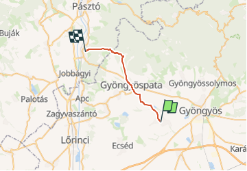
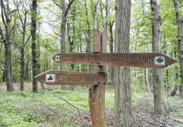
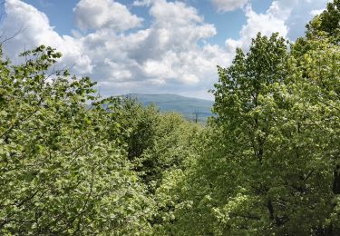
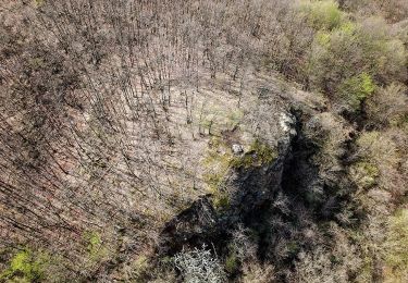
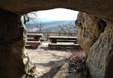
Randonnée A pied de 19,6 km à découvrir à Grande plaine et nord, Heves megye, Nagyréde. Cette randonnée est proposée par SityTrail - itinéraires balisés pédestres.
Description
Randonnée créée par MUTKE.
Localisation
Pays :
Hongrie
Région :
Grande plaine et nord
Département/Province :
Heves megye
Commune :
Nagyréde
Localité :
Unknown
Départ:(Dec)
Départ:(UTM)
413742 ; 5290799 (34T) N.
Commentaires
Randonnées à proximité
![Randonnée A pied Szurdokpüspöki - Mária Út M56-01 - Photo](https://media.geolcdn.com/t/375/260/2bc93b56-8d7b-4a64-b65d-8ffada04e206.jpeg&format=jpg&maxdim=2)
![A pied A pied](https://static1.geolcdn.com/sitytour/trail-icons/100.png)
Mária Út M56-01
A pied
Facile
Szurdokpüspöki,
Grande plaine et nord,
Nógrád megye,
Hongrie
![](/images/other/stat-length.png)
14,4 km | 15,6 km-effort
3h 32min
![](https://static1.geolcdn.com/siteimages/upload/files/16400158638029165_repeat_loop_refresh_sync_direction_icon.png)
Non
![Randonnée A pied Jászárokszállás - Mária Út M56-03 - Photo](https://media.geolcdn.com/t/375/260/32a97334-9531-4a8d-96b7-5494edcd8f86.jpeg&format=jpg&maxdim=2)
![A pied A pied](https://static1.geolcdn.com/sitytour/trail-icons/100.png)
Mária Út M56-03
A pied
Moyen
Jászárokszállás,
Grande plaine et nord,
Jász-Nagykun-Szolnok megye,
Hongrie
![](/images/other/stat-length.png)
21 km | 22 km-effort
5h 1min
![](https://static1.geolcdn.com/siteimages/upload/files/16400158638029165_repeat_loop_refresh_sync_direction_icon.png)
Non
![Randonnée A pied Parád - S+ - Photo](https://media.geolcdn.com/t/375/260/9ca43b40-9011-4135-a1cf-0773701c74ef.jpeg&format=jpg&maxdim=2)
![A pied A pied](https://static1.geolcdn.com/sitytour/trail-icons/100.png)
S+
A pied
Facile
Parád,
Grande plaine et nord,
Heves megye,
Hongrie
![](/images/other/stat-length.png)
5,2 km | 6,8 km-effort
1h 32min
![](https://static1.geolcdn.com/siteimages/upload/files/16400158638029165_repeat_loop_refresh_sync_direction_icon.png)
Non
![Randonnée A pied Markaz - ZL (Hegyes-tető-Markazi várrom) - Photo](https://media.geolcdn.com/t/375/260/1129ceab-95b3-4fea-af78-2eb562019c5b.jpeg&format=jpg&maxdim=2)
![A pied A pied](https://static1.geolcdn.com/sitytour/trail-icons/100.png)
ZL (Hegyes-tető-Markazi várrom)
A pied
Facile
Markaz,
Grande plaine et nord,
Heves megye,
Hongrie
![](/images/other/stat-length.png)
5,7 km | 7,7 km-effort
1h 44min
![](https://static1.geolcdn.com/siteimages/upload/files/16400158638029165_repeat_loop_refresh_sync_direction_icon.png)
Non
![Randonnée A pied Gyöngyöspata - S+ (Tóthegyes-János-vára) - Photo](https://media.geolcdn.com/t/375/260/9e64f252-51a3-49e9-b9f1-330402f89d90.jpeg&format=jpg&maxdim=2)
![A pied A pied](https://static1.geolcdn.com/sitytour/trail-icons/100.png)
S+ (Tóthegyes-János-vára)
A pied
Moyen
Gyöngyöspata,
Grande plaine et nord,
Heves megye,
Hongrie
![](/images/other/stat-length.png)
12,6 km | 22 km-effort
5h 4min
![](https://static1.geolcdn.com/siteimages/upload/files/16400158638029165_repeat_loop_refresh_sync_direction_icon.png)
Non
![Randonnée A pied Szurdokpüspöki - P3 (Pásztó-Muzsla tető) - Photo](https://media.geolcdn.com/t/375/260/30a210c6-3454-4688-be41-523ead2c5efe.jpeg&format=jpg&maxdim=2)
![A pied A pied](https://static1.geolcdn.com/sitytour/trail-icons/100.png)
P3 (Pásztó-Muzsla tető)
A pied
Facile
Szurdokpüspöki,
Grande plaine et nord,
Nógrád megye,
Hongrie
![](/images/other/stat-length.png)
7,6 km | 9,9 km-effort
2h 15min
![](https://static1.geolcdn.com/siteimages/upload/files/16400158638029165_repeat_loop_refresh_sync_direction_icon.png)
Non
![Randonnée A pied Pásztó - Z+ (Pásztó-Keresztesi nyereg) - Photo](https://media.geolcdn.com/t/375/260/458a34b0-255a-428f-91c9-43319923121d.jpeg&format=jpg&maxdim=2)
![A pied A pied](https://static1.geolcdn.com/sitytour/trail-icons/100.png)
Z+ (Pásztó-Keresztesi nyereg)
A pied
Moyen
Pásztó,
Grande plaine et nord,
Nógrád megye,
Hongrie
![](/images/other/stat-length.png)
15 km | 24 km-effort
5h 21min
![](https://static1.geolcdn.com/siteimages/upload/files/16400158638029165_repeat_loop_refresh_sync_direction_icon.png)
Non
![Randonnée A pied Gyöngyössolymos - S3 (Lajosháza - Őrlőmű - Dezsővár - Csigéd-farok) - Photo](https://media.geolcdn.com/t/375/260/4d7c1c93-3826-481b-8351-49a62c6524aa.jpeg&format=jpg&maxdim=2)
![A pied A pied](https://static1.geolcdn.com/sitytour/trail-icons/100.png)
S3 (Lajosháza - Őrlőmű - Dezsővár - Csigéd-farok)
A pied
Facile
Gyöngyössolymos,
Grande plaine et nord,
Heves megye,
Hongrie
![](/images/other/stat-length.png)
3,8 km | 5,2 km-effort
1h 10min
![](https://static1.geolcdn.com/siteimages/upload/files/16400158638029165_repeat_loop_refresh_sync_direction_icon.png)
Non
![Randonnée A pied Mátraszentimre - Mária út M10/10 Mátraverebély-Szentkút - Fallóskút - Photo](https://media.geolcdn.com/t/375/260/d3309216-208b-4b94-9293-4bd45d671121.jpeg&format=jpg&maxdim=2)
![A pied A pied](https://static1.geolcdn.com/sitytour/trail-icons/100.png)
Mária út M10/10 Mátraverebély-Szentkút - Fallóskút
A pied
Moyen
Mátraszentimre,
Grande plaine et nord,
Heves megye,
Hongrie
![](/images/other/stat-length.png)
22 km | 29 km-effort
6h 31min
![](https://static1.geolcdn.com/siteimages/upload/files/16400158638029165_repeat_loop_refresh_sync_direction_icon.png)
Non