![](/images/other/stat-length.png)
![Randonnée A pied okres Lučenec - Mučínska jaskyňa - Photo](https://media.geolcdn.com/t/1900/400/ext.pjpeg?maxdim=2&url=https%3A%2F%2Fstatic1.geolcdn.com%2Fsiteimages%2Fupload%2Ffiles%2F1545311037marcheuse_200dpi.jpg)
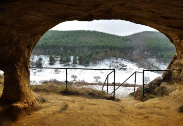
Mučínska jaskyňa
SityTrail - itinéraires balisés pédestres
Tous les sentiers balisés d’Europe GUIDE+
![Longueur](/images/other/stat-length.png)
Longueur
3,2 km
![Altitude max](https://static1.geolcdn.com/siteimages/upload/files/1508320355ic_sort_altitude_max_24dp.png)
Altitude max
331 m
![Dénivelé positif](https://static1.geolcdn.com/siteimages/upload/files/1508320355ic_sort_den_pos_24dp.png)
Dénivelé positif
143 m
![Km-Effort](/images/other/stat-length.png)
Km-Effort
4,6 km
![Altitude min](https://static1.geolcdn.com/siteimages/upload/files/1508320355ic_sort_altitude_min_24dp.png)
Altitude min
188 m
![Dénivelé négatif](https://static1.geolcdn.com/siteimages/upload/files/1508320355ic_sort_den_neg_24dp.png)
Dénivelé négatif
7 m
![Boucle](https://static1.geolcdn.com/siteimages/upload/files/16400158638029165_repeat_loop_refresh_sync_direction_icon.png)
Boucle
Non
Balise
Date de création :
2022-02-21 10:58:07.369
Dernière modification :
2022-02-21 10:58:07.369
![A pied](https://static1.geolcdn.com/sitytour/trail-icons/100.png)
1h03
Difficulté : Facile
![Scannez ce code QR pour ouvrir la randonnée dans l'application SityTrail](https://capi.geolives.com/qq0zvz2zws4bq2lad0pu/sitytour/trails/3139922/qr.png?size=200)
Application GPS de randonnée GRATUITE
À propos
Randonnée A pied de 3,2 km à découvrir à Région de Banská Bystrica, Inconnu, okres Lučenec. Cette randonnée est proposée par SityTrail - itinéraires balisés pédestres.
Description
Randonnée créée par Obec Mučín.
Symbole: education
Localisation
Pays :
Slovaquie
Région :
Région de Banská Bystrica
Département/Province :
Inconnu
Commune :
okres Lučenec
Localité :
Mučín
Départ:(Dec)
Départ:(UTM)
403389 ; 5344538 (34U) N.
Commentaires
Randonnées à proximité
![Randonnée A pied Salgótarján - Bányász körút - Photo](https://media.geolcdn.com/t/375/260/aac96509-b9ce-4f0d-b83e-bece29d9db4a.jpeg&format=jpg&maxdim=2)
![A pied A pied](https://static1.geolcdn.com/sitytour/trail-icons/100.png)
Bányász körút
A pied
Très difficile
Salgótarján,
Grande plaine et nord,
Nógrád megye,
Hongrie
![](/images/other/stat-length.png)
37 km | 55 km-effort
12h 23min
![](https://static1.geolcdn.com/siteimages/upload/files/16400158638029165_repeat_loop_refresh_sync_direction_icon.png)
Oui
![Randonnée A pied Salgótarján - Eresztvényi bányák tanösvény - Photo](https://media.geolcdn.com/t/375/260/76eb28a4-95d2-4843-a03d-28b127786b9f.jpeg&format=jpg&maxdim=2)
![A pied A pied](https://static1.geolcdn.com/sitytour/trail-icons/100.png)
Eresztvényi bányák tanösvény
A pied
Facile
Salgótarján,
Grande plaine et nord,
Nógrád megye,
Hongrie
![](/images/other/stat-length.png)
5,1 km | 6,8 km-effort
1h 33min
![](https://static1.geolcdn.com/siteimages/upload/files/16400158638029165_repeat_loop_refresh_sync_direction_icon.png)
Non
![Randonnée A pied Salgótarján - P■ - Photo](https://media.geolcdn.com/t/375/260/feb61641-05bd-4d28-9e24-a963ae19dd3c.jpeg&format=jpg&maxdim=2)
![A pied A pied](https://static1.geolcdn.com/sitytour/trail-icons/100.png)
P■
A pied
Facile
Salgótarján,
Grande plaine et nord,
Nógrád megye,
Hongrie
![](/images/other/stat-length.png)
5,3 km | 8,8 km-effort
1h 59min
![](https://static1.geolcdn.com/siteimages/upload/files/16400158638029165_repeat_loop_refresh_sync_direction_icon.png)
Non
![Randonnée A pied Salgótarján - P▲ (P sáv - Pécs-kő) - Photo](https://media.geolcdn.com/t/375/260/d92ca402-c66f-4b73-8fa5-3a1af3690007.jpeg&format=jpg&maxdim=2)
![A pied A pied](https://static1.geolcdn.com/sitytour/trail-icons/100.png)
P▲ (P sáv - Pécs-kő)
A pied
Facile
Salgótarján,
Grande plaine et nord,
Nógrád megye,
Hongrie
![](/images/other/stat-length.png)
3,7 km | 4,8 km-effort
1h 5min
![](https://static1.geolcdn.com/siteimages/upload/files/16400158638029165_repeat_loop_refresh_sync_direction_icon.png)
Non
![Randonnée A pied Salgótarján - PL (Dornyai-th - Salgóvár - Zagyvaróna) - Photo](https://media.geolcdn.com/t/375/260/4ab0a3fb-d232-4328-9e7c-1fc9c7efec39.jpeg&format=jpg&maxdim=2)
![A pied A pied](https://static1.geolcdn.com/sitytour/trail-icons/100.png)
PL (Dornyai-th - Salgóvár - Zagyvaróna)
A pied
Facile
Salgótarján,
Grande plaine et nord,
Nógrád megye,
Hongrie
![](/images/other/stat-length.png)
3,4 km | 5,2 km-effort
1h 10min
![](https://static1.geolcdn.com/siteimages/upload/files/16400158638029165_repeat_loop_refresh_sync_direction_icon.png)
Non
![Randonnée A pied Salgótarján - S■ - Photo](https://media.geolcdn.com/t/375/260/768a8642-8191-4b87-9008-c8dcfa641360.jpeg&format=jpg&maxdim=2)
![A pied A pied](https://static1.geolcdn.com/sitytour/trail-icons/100.png)
S■
A pied
Facile
Salgótarján,
Grande plaine et nord,
Nógrád megye,
Hongrie
![](/images/other/stat-length.png)
3,8 km | 4,9 km-effort
1h 7min
![](https://static1.geolcdn.com/siteimages/upload/files/16400158638029165_repeat_loop_refresh_sync_direction_icon.png)
Non
![Randonnée A pied Salgótarján - Z■ - Photo](https://media.geolcdn.com/t/375/260/35cb82aa-45ca-4462-8cbd-28a30db8f2bf.jpeg&format=jpg&maxdim=2)
![A pied A pied](https://static1.geolcdn.com/sitytour/trail-icons/100.png)
Z■
A pied
Facile
Salgótarján,
Grande plaine et nord,
Nógrád megye,
Hongrie
![](/images/other/stat-length.png)
3,7 km | 5,3 km-effort
1h 11min
![](https://static1.geolcdn.com/siteimages/upload/files/16400158638029165_repeat_loop_refresh_sync_direction_icon.png)
Non
![Randonnée A pied Kishartyán - Z+ - Photo](https://media.geolcdn.com/t/375/260/85e59417-3a68-42b4-b5ae-5f791582870b.jpeg&format=jpg&maxdim=2)
![A pied A pied](https://static1.geolcdn.com/sitytour/trail-icons/100.png)
Z+
A pied
Facile
Kishartyán,
Grande plaine et nord,
Nógrád megye,
Hongrie
![](/images/other/stat-length.png)
4,4 km | 5,9 km-effort
1h 21min
![](https://static1.geolcdn.com/siteimages/upload/files/16400158638029165_repeat_loop_refresh_sync_direction_icon.png)
Non
![Randonnée A pied Ipolytarnóc - Z+ Ipolytarnóc-Karancslapujtő - Photo](https://media.geolcdn.com/t/375/260/9d04ca60-71ae-4b53-a533-50e7d946da3d.jpeg&format=jpg&maxdim=2)
![A pied A pied](https://static1.geolcdn.com/sitytour/trail-icons/100.png)
Z+ Ipolytarnóc-Karancslapujtő
A pied
Moyen
Ipolytarnóc,
Grande plaine et nord,
Nógrád megye,
Hongrie
![](/images/other/stat-length.png)
18,7 km | 26 km-effort
5h 56min
![](https://static1.geolcdn.com/siteimages/upload/files/16400158638029165_repeat_loop_refresh_sync_direction_icon.png)
Non