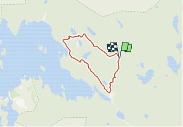
![](/images/other/stat-length.png)
![Randonnée A pied Inconnu - Stigmansrundan - Photo](https://media.geolcdn.com/t/1900/400/0e2de3a6-805a-4e6b-9b73-3069f681ddfc.jpeg&format=pjpeg&maxdim=2)
Stigmansrundan
SityTrail - itinéraires balisés pédestres
Tous les sentiers balisés d’Europe GUIDE+
![Longueur](/images/other/stat-length.png)
![Altitude max](https://static1.geolcdn.com/siteimages/upload/files/1508320355ic_sort_altitude_max_24dp.png)
![Dénivelé positif](https://static1.geolcdn.com/siteimages/upload/files/1508320355ic_sort_den_pos_24dp.png)
![Km-Effort](/images/other/stat-length.png)
![Altitude min](https://static1.geolcdn.com/siteimages/upload/files/1508320355ic_sort_altitude_min_24dp.png)
![Dénivelé négatif](https://static1.geolcdn.com/siteimages/upload/files/1508320355ic_sort_den_neg_24dp.png)
![Boucle](https://static1.geolcdn.com/siteimages/upload/files/16400158638029165_repeat_loop_refresh_sync_direction_icon.png)
![A pied](https://static1.geolcdn.com/sitytour/trail-icons/100.png)
1h06
Difficulté : Facile
![Scannez ce code QR pour ouvrir la randonnée dans l'application SityTrail](https://capi.geolives.com/qq0zvz2zws4bq2lad0pu/sitytour/trails/3139854/qr.png?size=200)
Application GPS de randonnée GRATUITE
À propos
Randonnée A pied de 3,9 km à découvrir à Comté d'Örebro, Inconnu, Inconnu. Cette randonnée est proposée par SityTrail - itinéraires balisés pédestres.
Description
Page not found. It may have been moved or removed completely.
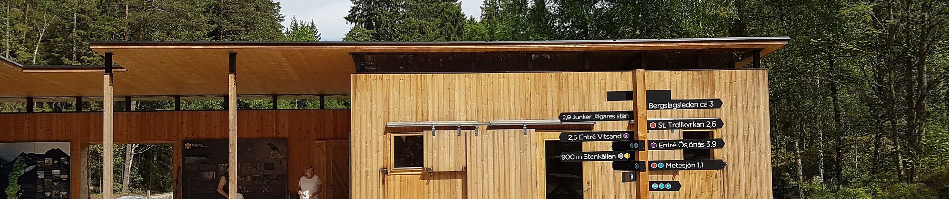
Site web: http://www.nationalparksofsweden.se/globalassets/tiveden/nationalparksfakta/kartor-dokument/faktablad-stigmansrundan-eng.pdf
Localisation
Commentaires
Randonnées à proximité
![Randonnée A pied Inconnu - Oxögabergsrundan - Photo](https://media.geolcdn.com/t/375/260/0e2de3a6-805a-4e6b-9b73-3069f681ddfc.jpeg&format=jpg&maxdim=2)
![A pied A pied](https://static1.geolcdn.com/sitytour/trail-icons/100.png)
A pied
![](/images/other/stat-length.png)
![](https://static1.geolcdn.com/siteimages/upload/files/16400158638029165_repeat_loop_refresh_sync_direction_icon.png)
![Randonnée A pied Inconnu - Trehörningsrundan - Photo](https://media.geolcdn.com/t/375/260/078e3f59-7358-48a0-a671-c5efa139b6e0.jpeg&format=jpg&maxdim=2)
![A pied A pied](https://static1.geolcdn.com/sitytour/trail-icons/100.png)
A pied
![](/images/other/stat-length.png)
![](https://static1.geolcdn.com/siteimages/upload/files/16400158638029165_repeat_loop_refresh_sync_direction_icon.png)
![Randonnée A pied Inconnu - Trollkyrkorundan - Photo](https://media.geolcdn.com/t/375/260/0e2de3a6-805a-4e6b-9b73-3069f681ddfc.jpeg&format=jpg&maxdim=2)
![A pied A pied](https://static1.geolcdn.com/sitytour/trail-icons/100.png)
A pied
![](/images/other/stat-length.png)
![](https://static1.geolcdn.com/siteimages/upload/files/16400158638029165_repeat_loop_refresh_sync_direction_icon.png)
![Randonnée A pied Inconnu - Tivedstorps skogspromenad 5 km - Photo](https://media.geolcdn.com/t/375/260/ext.jpg?maxdim=2&url=https%3A%2F%2Fstatic1.geolcdn.com%2Fsiteimages%2Fupload%2Ffiles%2F1545311037marcheuse_200dpi.jpg)
![A pied A pied](https://static1.geolcdn.com/sitytour/trail-icons/100.png)
A pied
![](/images/other/stat-length.png)
![](https://static1.geolcdn.com/siteimages/upload/files/16400158638029165_repeat_loop_refresh_sync_direction_icon.png)
![Randonnée A pied Inconnu - Kyrkstigen Tivedstorp - Tiveds kyrka - Photo](https://media.geolcdn.com/t/375/260/ext.jpg?maxdim=2&url=https%3A%2F%2Fstatic1.geolcdn.com%2Fsiteimages%2Fupload%2Ffiles%2F1545311037marcheuse_200dpi.jpg)
![A pied A pied](https://static1.geolcdn.com/sitytour/trail-icons/100.png)
A pied
![](/images/other/stat-length.png)
![](https://static1.geolcdn.com/siteimages/upload/files/16400158638029165_repeat_loop_refresh_sync_direction_icon.png)