![](/images/other/stat-length.png)
![Randonnée A pied Unknown - Andros Routes 13 - Photo](https://media.geolcdn.com/t/1900/400/ext.pjpeg?maxdim=2&url=https%3A%2F%2Fstatic1.geolcdn.com%2Fsiteimages%2Fupload%2Ffiles%2F1545311037marcheuse_200dpi.jpg)
Andros Routes 13
SityTrail - itinéraires balisés pédestres
Tous les sentiers balisés d’Europe PRO
![Longueur](/images/other/stat-length.png)
Longueur
8 km
![Altitude max](https://static1.geolcdn.com/siteimages/upload/files/1508320355ic_sort_altitude_max_24dp.png)
Altitude max
416 m
![Dénivelé positif](https://static1.geolcdn.com/siteimages/upload/files/1508320355ic_sort_den_pos_24dp.png)
Dénivelé positif
138 m
![Km-Effort](/images/other/stat-length.png)
Km-Effort
11 km
![Altitude min](https://static1.geolcdn.com/siteimages/upload/files/1508320355ic_sort_altitude_min_24dp.png)
Altitude min
5 m
![Dénivelé négatif](https://static1.geolcdn.com/siteimages/upload/files/1508320355ic_sort_den_neg_24dp.png)
Dénivelé négatif
502 m
![Boucle](https://static1.geolcdn.com/siteimages/upload/files/16400158638029165_repeat_loop_refresh_sync_direction_icon.png)
Boucle
Non
Balise
Date de création :
2022-02-21 10:49:25.51
Dernière modification :
2022-03-09 00:25:10.93
![A pied](https://static1.geolcdn.com/sitytour/trail-icons/100.png)
2h30
Difficulté : Facile
![Scannez ce code QR pour ouvrir la randonnée dans l'application SityTrail](https://capi.geolives.com/qq0zvz2zws4bq2lad0pu/sitytour/trails/3139635/qr.png?size=200)
Application GPS de randonnée GRATUITE
À propos
Randonnée A pied de 8 km à découvrir à Égée, Περιφερειακή Ενότητα Άνδρου. Cette randonnée est proposée par SityTrail - itinéraires balisés pédestres.
Description
Randonnée créée par Andros Routes.
Symbole: red_rectangle
Site web: https://www.androsroutes.gr/
Localisation
Pays :
Grèce
Région :
Égée
Département/Province :
Περιφερειακή Ενότητα Άνδρου
Commune :
Unknown
Localité :
Unknown
Départ:(Dec)
Départ:(UTM)
309849 ; 4191890 (35S) N.
Commentaires
Randonnées à proximité
![Randonnée A pied - Andros Routes 11 - Photo](https://media.geolcdn.com/t/375/260/ext.jpg?maxdim=2&url=https%3A%2F%2Fmedia.geolcdn.com%2Ff%2F6909892e-51ec-4943-a3a7-329549f59973.jpeg)
![A pied A pied](https://static1.geolcdn.com/sitytour/trail-icons/100.png)
Andros Routes 11
A pied
Facile
,
Égée,
Περιφερειακή Ενότητα Άνδρου,
Grèce
![](/images/other/stat-length.png)
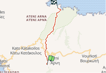
8,6 km | 16,1 km-effort
3h 40min
![](https://static1.geolcdn.com/siteimages/upload/files/16400158638029165_repeat_loop_refresh_sync_direction_icon.png)
Non
![Randonnée A pied - Andros Routes 16 - Photo](https://media.geolcdn.com/t/375/260/ext.jpg?maxdim=2&url=https%3A%2F%2Fmedia.geolcdn.com%2Ff%2F38a81b7b-5f15-48d9-88ff-562f4c47b63f.jpeg)
![A pied A pied](https://static1.geolcdn.com/sitytour/trail-icons/100.png)
Andros Routes 16
A pied
Facile
,
Égée,
Περιφερειακή Ενότητα Άνδρου,
Grèce
![](/images/other/stat-length.png)
5,8 km | 10,4 km-effort
2h 21min
![](https://static1.geolcdn.com/siteimages/upload/files/16400158638029165_repeat_loop_refresh_sync_direction_icon.png)
Non
![Randonnée A pied - Andros Routes 9 - Photo](https://media.geolcdn.com/t/375/260/ext.jpg?maxdim=2&url=https%3A%2F%2Fmedia.geolcdn.com%2Ff%2F70a7c804-9701-41c4-be94-83e75bfd7b66.jpeg)
![A pied A pied](https://static1.geolcdn.com/sitytour/trail-icons/100.png)
Andros Routes 9
A pied
Facile
,
Égée,
Περιφερειακή Ενότητα Άνδρου,
Grèce
![](/images/other/stat-length.png)
11 km | 15,9 km-effort
3h 37min
![](https://static1.geolcdn.com/siteimages/upload/files/16400158638029165_repeat_loop_refresh_sync_direction_icon.png)
Non
![Randonnée A pied - Andros Routes 6 - Photo](https://media.geolcdn.com/t/375/260/ext.jpg?maxdim=2&url=https%3A%2F%2Fmedia.geolcdn.com%2Ff%2Fe41284be-0caa-4439-a09f-2c256fe38208.jpeg)
![A pied A pied](https://static1.geolcdn.com/sitytour/trail-icons/100.png)
Andros Routes 6
A pied
Facile
,
Égée,
Περιφερειακή Ενότητα Άνδρου,
Grèce
![](/images/other/stat-length.png)
9,2 km | 13,1 km-effort
2h 58min
![](https://static1.geolcdn.com/siteimages/upload/files/16400158638029165_repeat_loop_refresh_sync_direction_icon.png)
Non
![Randonnée A pied - Andros Routes 11a - Photo](https://media.geolcdn.com/t/375/260/ext.jpg?maxdim=2&url=https%3A%2F%2Fstatic1.geolcdn.com%2Fsiteimages%2Fupload%2Ffiles%2F1545311037marcheuse_200dpi.jpg)
![A pied A pied](https://static1.geolcdn.com/sitytour/trail-icons/100.png)
Andros Routes 11a
A pied
Facile
,
Égée,
Περιφερειακή Ενότητα Άνδρου,
Grèce
![](/images/other/stat-length.png)
3,4 km | 5,2 km-effort
1h 11min
![](https://static1.geolcdn.com/siteimages/upload/files/16400158638029165_repeat_loop_refresh_sync_direction_icon.png)
Non
![Randonnée A pied - Andros Routes 12 - Photo](https://media.geolcdn.com/t/375/260/ext.jpg?maxdim=2&url=https%3A%2F%2Fstatic1.geolcdn.com%2Fsiteimages%2Fupload%2Ffiles%2F1545311037marcheuse_200dpi.jpg)
![A pied A pied](https://static1.geolcdn.com/sitytour/trail-icons/100.png)
Andros Routes 12
A pied
Facile
,
Égée,
Περιφερειακή Ενότητα Άνδρου,
Grèce
![](/images/other/stat-length.png)
6,9 km | 13,3 km-effort
3h 0min
![](https://static1.geolcdn.com/siteimages/upload/files/16400158638029165_repeat_loop_refresh_sync_direction_icon.png)
Non
![Randonnée Randonnée équestre - Vallée Mesaria - Photo](https://media.geolcdn.com/t/375/260/ext.jpg?maxdim=2&url=https%3A%2F%2Fstatic1.geolcdn.com%2Fsiteimages%2Fupload%2Ffiles%2F1524743154cheval.jpg)
![Randonnée équestre Randonnée équestre](https://static1.geolcdn.com/sitytour/trail-icons/301.png)
Vallée Mesaria
Randonnée équestre
Facile
,
Égée,
Περιφερειακή Ενότητα Άνδρου,
Grèce
![](/images/other/stat-length.png)
9,9 km | 14 km-effort
1h 45min
![](https://static1.geolcdn.com/siteimages/upload/files/16400158638029165_repeat_loop_refresh_sync_direction_icon.png)
Oui
![Randonnée Randonnée équestre - Achla - Photo](https://media.geolcdn.com/t/375/260/ext.jpg?maxdim=2&url=https%3A%2F%2Fstatic1.geolcdn.com%2Fsiteimages%2Fupload%2Ffiles%2F1524743154cheval.jpg)
![Randonnée équestre Randonnée équestre](https://static1.geolcdn.com/sitytour/trail-icons/301.png)
Achla
Randonnée équestre
Facile
,
Égée,
Περιφερειακή Ενότητα Άνδρου,
Grèce
![](/images/other/stat-length.png)
11,6 km | 17,2 km-effort
1h 49min
![](https://static1.geolcdn.com/siteimages/upload/files/16400158638029165_repeat_loop_refresh_sync_direction_icon.png)
Oui
![Randonnée Randonnée équestre - Άνο οι τροφός - Photo](https://media.geolcdn.com/t/375/260/ext.jpg?maxdim=2&url=https%3A%2F%2Fstatic1.geolcdn.com%2Fsiteimages%2Fupload%2Ffiles%2F1524743154cheval.jpg)
![Randonnée équestre Randonnée équestre](https://static1.geolcdn.com/sitytour/trail-icons/301.png)
Άνο οι τροφός
Randonnée équestre
Facile
,
Égée,
Περιφερειακή Ενότητα Άνδρου,
Grèce
![](/images/other/stat-length.png)
9,9 km | 13,5 km-effort
1h 36min
![](https://static1.geolcdn.com/siteimages/upload/files/16400158638029165_repeat_loop_refresh_sync_direction_icon.png)
Oui