Randonnée A pied Geratal - Alter Flößgraben - Photo

Tous les sentiers balisés d’Europe GUIDE+

© OpenStreetMap contributors
Longueur
Longueur
12,2 km
Altitude max
Altitude max
609 m
Dénivelé positif
Dénivelé positif
153 m
Km-Effort
Km-Effort  
14,8 km
Altitude min
Altitude min
440 m
Dénivelé négatif
Dénivelé négatif
303 m
Boucle
Boucle
Non
Balise
Balise
Date de création :
2022-02-21 08:16:44.386
Dernière modification :
2022-02-21 08:16:44.386

(0 Avis)

A pied
A pied
3h21
Difficulté : Facile

Scannez ce code QR pour ouvrir la randonnée dans l'application SityTrail

Application GPS de randonnée GRATUITE

Logo SityTrail SityTrail

IGN / Instituts géographiques

Télécharger SityTrail sur l'App Store Télécharger SityTrail sur Google Play

Logo SityTrail SityTrail World

Le monde est à vous

Télécharger SityTrail sur l'App Store Télécharger SityTrail sur Google Play Télécharger SityTrail sur Huawei AppGallery

À propos

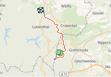
Randonnée A pied de 12,2 km à découvrir à Thuringe, Ilm-Kreis, Geratal. Cette randonnée est proposée par SityTrail - itinéraires balisés pédestres.

Description

Teilweise schlechte Kennzeichnung!

Symbole: 3 stilisierte Tannen

Profil altimétrique

Localisation

Pays :
Allemagne
Région :
Thuringe
Département/Province :
Ilm-Kreis
Commune :
Geratal
Localité :
Unknown
Départ:(UTM)
623985 ; 5621681 (32U) N.

Randonnées à proximité

Randonnée A pied Oberhof - Rundweg Oberhof - Photo
A pied
GUIDE+

A pied

Facile
Oberhof, Thuringe, Landkreis Schmalkalden-Meiningen, Allemagne
6 km | 8,1 km-effort
1h 49min
Non
Randonnée A pied Geratal - Rundwanderweg Lütsche-Flößgraben - Photo
A pied
GUIDE+

A pied

Facile
Geratal, Thuringe, Ilm-Kreis, Allemagne
11,3 km | 14 km-effort
3h 10min
Non
Randonnée A pied Luisenthal - DE-Grünes Quadrat - Photo
A pied
GUIDE+

A pied

Facile
Luisenthal, Thuringe, Landkreis Gotha, Allemagne
7,3 km | 10 km-effort
2h 16min
Non
Randonnée A pied Oberhof - Rennsteig-Leiter Luisenthal - Photo
A pied
GUIDE+

A pied

Facile
Oberhof, Thuringe, Landkreis Schmalkalden-Meiningen, Allemagne
9,3 km | 11,2 km-effort
2h 33min
Non
Randonnée A pied Luisenthal - DE-Gelbes Dreieck - Photo
A pied
GUIDE+

A pied

Facile
Luisenthal, Thuringe, Landkreis Gotha, Allemagne
5,1 km | 6,8 km-effort
1h 32min
Non
Randonnée A pied Geratal - Durch's Tal der Zahmen Gera - Photo
A pied
GUIDE+

A pied

Moyen
Geratal, Thuringe, Ilm-Kreis, Allemagne
17,4 km | 23 km-effort
5h 15min
Oui
Randonnée A pied Geratal - Geraberger Rundwanderweg - Photo
A pied
GUIDE+

A pied

Facile
Geratal, Thuringe, Ilm-Kreis, Allemagne
11,1 km | 15,6 km-effort
3h 32min
Oui
Randonnée A pied Geratal - Arlesberger Braunsteinweg - Photo
A pied
GUIDE+

A pied

Facile
Geratal, Thuringe, Ilm-Kreis, Allemagne
5,6 km | 8,7 km-effort
1h 58min
Non
Randonnée A pied Luisenthal - Rundweg Ohratalsperre - Photo
A pied
GUIDE+

A pied

Facile
Luisenthal, Thuringe, Landkreis Gotha, Allemagne
7,1 km | 8,7 km-effort
1h 59min
Non


Fermer
Mes abonnements