![](/images/other/stat-length.png)
![Randonnée Vélo Mennetou-sur-Cher - Par la forêt et les manoirs de Sologne - Photo](https://media.geolcdn.com/t/1900/400/ext.pjpeg?maxdim=2&url=https%3A%2F%2Fstatic1.geolcdn.com%2Fsiteimages%2Fupload%2Ffiles%2F1524743154velo.jpg)
Par la forêt et les manoirs de Sologne
Solognesud
Utilisateur
![Longueur](/images/other/stat-length.png)
Longueur
36 km
![Altitude max](https://static1.geolcdn.com/siteimages/upload/files/1508320355ic_sort_altitude_max_24dp.png)
Altitude max
132 m
![Dénivelé positif](https://static1.geolcdn.com/siteimages/upload/files/1508320355ic_sort_den_pos_24dp.png)
Dénivelé positif
281 m
![Km-Effort](/images/other/stat-length.png)
Km-Effort
40 km
![Altitude min](https://static1.geolcdn.com/siteimages/upload/files/1508320355ic_sort_altitude_min_24dp.png)
Altitude min
90 m
![Dénivelé négatif](https://static1.geolcdn.com/siteimages/upload/files/1508320355ic_sort_den_neg_24dp.png)
Dénivelé négatif
247 m
![Boucle](https://static1.geolcdn.com/siteimages/upload/files/16400158638029165_repeat_loop_refresh_sync_direction_icon.png)
Boucle
Non
Date de création :
2014-12-10 00:00:00.0
Dernière modification :
2014-12-10 00:00:00.0
![Vélo](https://static1.geolcdn.com/sitytour/trail-icons/200.png)
2h19
Difficulté : Facile
![Scannez ce code QR pour ouvrir la randonnée dans l'application SityTrail](https://capi.geolives.com/qq0zvz2zws4bq2lad0pu/sitytour/trails/313443/qr.png?size=200)
Application GPS de randonnée GRATUITE
À propos
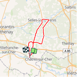
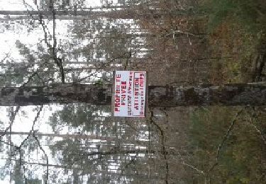
Randonnée Vélo de 36 km à découvrir à Centre-Val de Loire, Loir-et-Cher, Mennetou-sur-Cher. Cette randonnée est proposée par Solognesud.
Description
Au départ de la cité médiévale de Mennetou sur Cher, un circuit vélo de 36 km à travers la forêt de Sologne et ses manoirs.
Points d'intérêt
Localisation
Pays :
France
Région :
Centre-Val de Loire
Département/Province :
Loir-et-Cher
Commune :
Mennetou-sur-Cher
Localité :
Unknown
Départ:(Dec)
Départ:(UTM)
414275 ; 5235725 (31T) N.
Commentaires
Randonnées à proximité
![Randonnée Marche Mennetou-sur-Cher - Entre forêt et manoirs, sur le chemin des Barres - Photo](https://media.geolcdn.com/t/375/260/ext.jpg?maxdim=2&url=https%3A%2F%2Fservices.sitytrail.com%2FGeolivesWS%2FDownloadMedia.ashx%3FTrailID%3D311844%26Media%3Ddfdba42c-5716-4a31-b350-44153d9e554b.jpg)
![Marche Marche](https://static1.geolcdn.com/sitytour/trail-icons/101.png)
Entre forêt et manoirs, sur le chemin des Barres
Marche
Facile
(2)
Mennetou-sur-Cher,
Centre-Val de Loire,
Loir-et-Cher,
France
![](/images/other/stat-length.png)
10,8 km | 12,1 km-effort
2h 42min
![](https://static1.geolcdn.com/siteimages/upload/files/16400158638029165_repeat_loop_refresh_sync_direction_icon.png)
Oui
![Randonnée Marche Mennetou-sur-Cher - Chemin du Briou - Mennetou-sur-Cher - Photo](https://media.geolcdn.com/t/375/260/ext.jpg?maxdim=2&url=https%3A%2F%2Fservices.sitytrail.com%2FGeolivesWS%2FDownloadMedia.ashx%3FTrailID%3D105100%26Media%3D8694_6.jpg)
![Marche Marche](https://static1.geolcdn.com/sitytour/trail-icons/101.png)
Chemin du Briou - Mennetou-sur-Cher
Marche
Facile
Mennetou-sur-Cher,
Centre-Val de Loire,
Loir-et-Cher,
France
![](/images/other/stat-length.png)
7,7 km | 8,7 km-effort
2h 0min
![](https://static1.geolcdn.com/siteimages/upload/files/16400158638029165_repeat_loop_refresh_sync_direction_icon.png)
Oui
![Randonnée Vélo Mennetou-sur-Cher - Entre Berry et Sologne - Photo](https://media.geolcdn.com/t/375/260/ext.jpg?maxdim=2&url=https%3A%2F%2Fservices.sitytrail.com%2FGeolivesWS%2FDownloadMedia.ashx%3FTrailID%3D311913%26Media%3D1bd949bd-e8b3-4f8c-9132-fb2566c803fb.jpg)
![Vélo Vélo](https://static1.geolcdn.com/sitytour/trail-icons/200.png)
Entre Berry et Sologne
Vélo
Facile
Mennetou-sur-Cher,
Centre-Val de Loire,
Loir-et-Cher,
France
![](/images/other/stat-length.png)
23 km | 25 km-effort
1h 29min
![](https://static1.geolcdn.com/siteimages/upload/files/16400158638029165_repeat_loop_refresh_sync_direction_icon.png)
Oui
![Randonnée Marche Mennetou-sur-Cher - MENNETOU - Photo](https://media.geolcdn.com/t/375/260/ext.jpg?maxdim=2&url=https%3A%2F%2Fservices.sitytrail.com%2FGeolivesWS%2FDownloadMedia.ashx%3FTrailID%3D253304%26Media%3De343b29e-f8c1-463c-8735-a50559882643.jpg)
![Marche Marche](https://static1.geolcdn.com/sitytour/trail-icons/101.png)
MENNETOU
Marche
Facile
Mennetou-sur-Cher,
Centre-Val de Loire,
Loir-et-Cher,
France
![](/images/other/stat-length.png)
12 km | 13,3 km-effort
2h 57min
![](https://static1.geolcdn.com/siteimages/upload/files/16400158638029165_repeat_loop_refresh_sync_direction_icon.png)
Oui
![Randonnée Marche Mennetou-sur-Cher - mennetou sur cher - Photo](https://media.geolcdn.com/t/375/260/ext.jpg?maxdim=2&url=https%3A%2F%2Fstatic1.geolcdn.com%2Fsiteimages%2Fupload%2Ffiles%2F1553511878bg_sport_marche.png)
![Marche Marche](https://static1.geolcdn.com/sitytour/trail-icons/101.png)
mennetou sur cher
Marche
Facile
Mennetou-sur-Cher,
Centre-Val de Loire,
Loir-et-Cher,
France
![](/images/other/stat-length.png)
19,6 km | 22 km-effort
3h 9min
![](https://static1.geolcdn.com/siteimages/upload/files/16400158638029165_repeat_loop_refresh_sync_direction_icon.png)
Oui
![Randonnée Marche Thénioux - thenioux - Photo](https://media.geolcdn.com/t/375/260/ext.jpg?maxdim=2&url=https%3A%2F%2Fstatic1.geolcdn.com%2Fsiteimages%2Fupload%2Ffiles%2F1553511878bg_sport_marche.png)
![Marche Marche](https://static1.geolcdn.com/sitytour/trail-icons/101.png)
thenioux
Marche
Très facile
Thénioux,
Centre-Val de Loire,
Cher,
France
![](/images/other/stat-length.png)
12,3 km | 13,7 km-effort
3h 1min
![](https://static1.geolcdn.com/siteimages/upload/files/16400158638029165_repeat_loop_refresh_sync_direction_icon.png)
Oui
![Randonnée Marche Langon-sur-Cher - les etrils langon - Photo](https://media.geolcdn.com/t/375/260/ext.jpg?maxdim=2&url=https%3A%2F%2Fstatic1.geolcdn.com%2Fsiteimages%2Fupload%2Ffiles%2F1553511878bg_sport_marche.png)
![Marche Marche](https://static1.geolcdn.com/sitytour/trail-icons/101.png)
les etrils langon
Marche
Très facile
Langon-sur-Cher,
Centre-Val de Loire,
Loir-et-Cher,
France
![](/images/other/stat-length.png)
14,3 km | 15,4 km-effort
2h 58min
![](https://static1.geolcdn.com/siteimages/upload/files/16400158638029165_repeat_loop_refresh_sync_direction_icon.png)
Oui
![Randonnée Marche Châtres-sur-Cher - la chatre sur cher - Photo](https://media.geolcdn.com/t/375/260/ext.jpg?maxdim=2&url=https%3A%2F%2Fstatic1.geolcdn.com%2Fsiteimages%2Fupload%2Ffiles%2F1553511878bg_sport_marche.png)
![Marche Marche](https://static1.geolcdn.com/sitytour/trail-icons/101.png)
la chatre sur cher
Marche
Très facile
Châtres-sur-Cher,
Centre-Val de Loire,
Loir-et-Cher,
France
![](/images/other/stat-length.png)
17,6 km | 19,4 km-effort
2h 42min
![](https://static1.geolcdn.com/siteimages/upload/files/16400158638029165_repeat_loop_refresh_sync_direction_icon.png)
Oui
![Randonnée Marche Saint-Loup - rando saint loup - Photo](https://media.geolcdn.com/t/375/260/ext.jpg?maxdim=2&url=https%3A%2F%2Fstatic1.geolcdn.com%2Fsiteimages%2Fupload%2Ffiles%2F1553511878bg_sport_marche.png)
![Marche Marche](https://static1.geolcdn.com/sitytour/trail-icons/101.png)
rando saint loup
Marche
Très facile
Saint-Loup,
Centre-Val de Loire,
Loir-et-Cher,
France
![](/images/other/stat-length.png)
12,3 km | 14 km-effort
2h 55min
![](https://static1.geolcdn.com/siteimages/upload/files/16400158638029165_repeat_loop_refresh_sync_direction_icon.png)
Oui