Randonnée Marche Thurnen - st_GL_exc09_access - Photo

Optez pour le retour à la nature GUIDE+

© OpenStreetMap contributors
Longueur
Longueur
18,3 km
Altitude max
Altitude max
1615 m
Dénivelé positif
Dénivelé positif
1214 m
Km-Effort
Km-Effort  
31 km
Altitude min
Altitude min
549 m
Dénivelé négatif
Dénivelé négatif
149 m
Boucle
Boucle
Non
Date de création :
2014-12-10 00:00:00.0
Dernière modification :
2014-12-10 00:00:00.0

(0 Avis)

Marche
Marche
5h48
Difficulté : Inconnu

Scannez ce code QR pour ouvrir la randonnée dans l'application SityTrail

Application GPS de randonnée GRATUITE

Logo SityTrail SityTrail

IGN / Instituts géographiques

Télécharger SityTrail sur l'App Store Télécharger SityTrail sur Google Play

Logo SityTrail SityTrail World

Le monde est à vous

Télécharger SityTrail sur l'App Store Télécharger SityTrail sur Google Play Télécharger SityTrail sur Huawei AppGallery

À propos

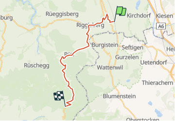
Randonnée Marche de 18,3 km à découvrir à Berne, Arrondissement administratif de Berne-Mittelland, Thurnen. Cette randonnée est proposée par My Switzerland.

Profil altimétrique

Localisation

Pays :
Suisse
Région :
Berne
Département/Province :
Arrondissement administratif de Berne-Mittelland
Commune :
Thurnen
Localité :
Unknown
Départ:(Dec)
Départ:(UTM)
386658 ; 5185580 (32T) N.

Randonnées à proximité

Randonnée Marche Wattenwil - hike27 - Photo
Marche
GUIDE+

Marche

Très facile
Wattenwil, Berne, Arrondissement administratif de Thoune, Suisse
20 km | 27 km-effort
Inconnu
Non
Randonnée V.T.T. Burgistein - Bike32890 - Photo
V.T.T.
GUIDE+

V.T.T.

Très facile
(1)
Burgistein, Berne, Arrondissement administratif de Thoune, Suisse
32 km | 47 km-effort
Inconnu
Oui
Randonnée Marche Toffen - Toffen-Bütschelegg-Thurnen - Photo
Marche
bffcuc

Marche

Très facile
Toffen, Berne, Arrondissement administratif de Berne-Mittelland, Suisse
14,7 km | 23 km-effort
3h 30min
Non
Randonnée Autre activité Uetendorf - Uetendorf - Gerzensee - Toffen - Photo
Autre activité
bffcuc

Autre activité

Très facile
Uetendorf, Berne, Arrondissement administratif de Thoune, Suisse
15,9 km | 21 km-effort
Inconnu
Non
Randonnée Autre activité Seftigen - Seftigen - Belp - Photo
Autre activité
bffcuc

Autre activité

Très facile
Seftigen, Berne, Arrondissement administratif de Thoune, Suisse
15 km | 22 km-effort
Inconnu
Non
Randonnée Autre activité Niedermuhlern - Niedermuhlern - Schwarzenburg - Photo
Autre activité
hallauer

Autre activité

Très facile
Niedermuhlern, Berne, Arrondissement administratif de Berne-Mittelland, Suisse
21 km | 31 km-effort
Inconnu
Non
Randonnée Autre activité Seftigen - Burgistein/Wattenwil - Schwarzenburg - Photo
Autre activité
hallauer

Autre activité

Très facile
Seftigen, Berne, Arrondissement administratif de Thoune, Suisse
22 km | 32 km-effort
7h 34min
Non
Randonnée Sports d'hiver Gerzensee - Chutzen - Belpberg - Photo
Sports d'hiver
gemalu

Sports d'hiver

Très facile
Gerzensee, Berne, Arrondissement administratif de Berne-Mittelland, Suisse
14,5 km | 22 km-effort
Inconnu
Oui
Randonnée Sports d'hiver Gerzensee - Güggel Nord - Photo
Sports d'hiver
gemalu

Sports d'hiver

Très facile
Gerzensee, Berne, Arrondissement administratif de Berne-Mittelland, Suisse
29 km | 43 km-effort
Inconnu
Oui


Fermer
Mes abonnements