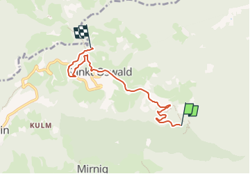
![](/images/other/stat-length.png)
![Randonnée A pied Eberstein - Eberstein's Sehenswürdigkeiten (Rundwanderung) - Photo](https://media.geolcdn.com/t/1900/400/1bcdbfbd-5e67-4223-ae4d-e90f056fa883.jpeg&format=pjpeg&maxdim=2)
Eberstein's Sehenswürdigkeiten (Rundwanderung)
SityTrail - itinéraires balisés pédestres
Tous les sentiers balisés d’Europe GUIDE+
![Longueur](/images/other/stat-length.png)
![Altitude max](https://static1.geolcdn.com/siteimages/upload/files/1508320355ic_sort_altitude_max_24dp.png)
![Dénivelé positif](https://static1.geolcdn.com/siteimages/upload/files/1508320355ic_sort_den_pos_24dp.png)
![Km-Effort](/images/other/stat-length.png)
![Altitude min](https://static1.geolcdn.com/siteimages/upload/files/1508320355ic_sort_altitude_min_24dp.png)
![Dénivelé négatif](https://static1.geolcdn.com/siteimages/upload/files/1508320355ic_sort_den_neg_24dp.png)
![Boucle](https://static1.geolcdn.com/siteimages/upload/files/16400158638029165_repeat_loop_refresh_sync_direction_icon.png)
![A pied](https://static1.geolcdn.com/sitytour/trail-icons/100.png)
1h52
Difficulté : Facile
![Scannez ce code QR pour ouvrir la randonnée dans l'application SityTrail](https://capi.geolives.com/qq0zvz2zws4bq2lad0pu/sitytour/trails/3129818/qr.png?size=200)
Application GPS de randonnée GRATUITE
À propos
Randonnée A pied de 5,1 km à découvrir à Carinthie, Bezirk Sankt Veit an der Glan, Eberstein. Cette randonnée est proposée par SityTrail - itinéraires balisés pédestres.
Description
Randonnée créée par ÖAV – Sektion Klagenfurt – Görtschitztal – Eberstein’s Sehenswürdigkeiten https://www.outdooractive.com/de/wanderung/eberstein/eberstein-s-sehenswuerdigkeiten-erwandern/35796176.
Diese Wanderung wird von folgenden überregionalen und regionalen Wanderwegen begleitet: Norischer Panoramaweg Hemmaweg Crna-Gurk
Localisation
Commentaires
Randonnées à proximité
![Randonnée A pied Wolfsberg - Saualpen-Südrunde - Photo](https://media.geolcdn.com/t/375/260/077f9a46-c65c-4128-9f0c-95f81e612863.jpeg&format=jpg&maxdim=2)
![A pied A pied](https://static1.geolcdn.com/sitytour/trail-icons/100.png)
A pied
![](/images/other/stat-length.png)
![](https://static1.geolcdn.com/siteimages/upload/files/16400158638029165_repeat_loop_refresh_sync_direction_icon.png)