


7,4 km | 11,3 km-effort
![Randonnée A pied Marktgemeinde Fieberbrunn - [3] Fieberbrunn - Karstein - Photo](https://media.geolcdn.com/t/1900/400/3deaf227-084c-4bb2-b343-4239f2614f36.jpeg&format=pjpeg&maxdim=2)

Tous les sentiers balisés d’Europe GUIDE+


Application GPS de randonnée GRATUITE
 SityTrail
IGN / Instituts géographiques
SityTrail World
Le monde est à vous
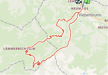
Randonnée A pied de 22 km à découvrir à Tyrol, Bezirk Kitzbühel, Marktgemeinde Fieberbrunn. Cette randonnée est proposée par SityTrail - itinéraires balisés pédestres.
Randonnée créée par Infrastrukturbetriebe Fieberbrunn.
Symbole: am Wegrand horizontal rot-weiß-rot teilweise mit schwarzer Wegnummer 3; auf Wegweisern schwarzer Text 3 auf gelbem Grund
![Randonnée A pied Marktgemeinde Fieberbrunn - [3] Fieberbrunn - Karstein - Photo 1](https://media.geolcdn.com/t/2048/auto/e8040533-add9-44ec-957a-500c7078819f.jpeg&format=jpg&maxdim=0 "Randonnée A pied Marktgemeinde Fieberbrunn - [3] Fieberbrunn - Karstein - Photo 1")
![Randonnée A pied Marktgemeinde Fieberbrunn - [3] Fieberbrunn - Karstein - Photo 2](https://media.geolcdn.com/t/2048/auto/f9422c0d-7b9e-4e87-b10e-5976da3b21cb.jpeg&format=jpg&maxdim=0 "Randonnée A pied Marktgemeinde Fieberbrunn - [3] Fieberbrunn - Karstein - Photo 2")
![Randonnée A pied Marktgemeinde Fieberbrunn - [3] Fieberbrunn - Karstein - Photo 3](https://media.geolcdn.com/t/2048/auto/66b1f816-a2eb-45de-9ed2-ace879b39d10.jpeg&format=jpg&maxdim=0 "Randonnée A pied Marktgemeinde Fieberbrunn - [3] Fieberbrunn - Karstein - Photo 3")
![Randonnée A pied Marktgemeinde Fieberbrunn - [3] Fieberbrunn - Karstein - Photo 4](https://media.geolcdn.com/t/2048/auto/1092cf09-bbc9-47cc-b619-1816d413fc1a.jpeg&format=jpg&maxdim=0 "Randonnée A pied Marktgemeinde Fieberbrunn - [3] Fieberbrunn - Karstein - Photo 4")
![Randonnée A pied Marktgemeinde Fieberbrunn - [3] Fieberbrunn - Karstein - Photo 5](https://media.geolcdn.com/t/2048/auto/3deaf227-084c-4bb2-b343-4239f2614f36.jpeg&format=jpg&maxdim=0 "Randonnée A pied Marktgemeinde Fieberbrunn - [3] Fieberbrunn - Karstein - Photo 5")
A pied
![Randonnée A pied Marktgemeinde Fieberbrunn - [12] Fieberbrunn Jägersteig - Photo](https://media.geolcdn.com/t/375/260/9edda448-f93a-4af8-b4d9-b9ec1461bad0.jpeg&format=jpg&maxdim=2)
A pied
![Randonnée A pied Marktgemeinde Fieberbrunn - [2] Fieberbrunner Höhenweg - Photo](https://media.geolcdn.com/t/375/260/e8040533-add9-44ec-957a-500c7078819f.jpeg&format=jpg&maxdim=2)
A pied
![Randonnée A pied Marktgemeinde Fieberbrunn - [1] Fieberbrunn - Wanderschuh - Photo](https://media.geolcdn.com/t/375/260/fd03419b-07ff-495d-9845-bd674901fd7c.jpeg&format=jpg&maxdim=2)
A pied
![Randonnée A pied Marktgemeinde Fieberbrunn - [9] Streuböden Talstation - Lärchfilzhochalm - Photo](https://media.geolcdn.com/t/375/260/f09ad1e6-3848-479a-a1b9-336695037d7f.jpeg&format=jpg&maxdim=2)
A pied
![Randonnée A pied Marktgemeinde Fieberbrunn - [4] Gebraweg - Photo](https://media.geolcdn.com/t/375/260/ext.jpg?maxdim=2&url=https%3A%2F%2Fstatic1.geolcdn.com%2Fsiteimages%2Fupload%2Ffiles%2F1545311037marcheuse_200dpi.jpg)
A pied
A pied
Autre activité
Autre activité