![](/images/other/stat-length.png)
![Randonnée A pied Ehrenhausen an der Weinstraße - Ehrenhausen 2 - Photo](https://media.geolcdn.com/t/1900/400/e5d71411-2f0d-4292-8ff2-c008b6f49357.jpeg&format=pjpeg&maxdim=2)
Ehrenhausen 2
SityTrail - itinéraires balisés pédestres
Tous les sentiers balisés d’Europe GUIDE+
![Longueur](/images/other/stat-length.png)
Longueur
3,9 km
![Altitude max](https://static1.geolcdn.com/siteimages/upload/files/1508320355ic_sort_altitude_max_24dp.png)
Altitude max
304 m
![Dénivelé positif](https://static1.geolcdn.com/siteimages/upload/files/1508320355ic_sort_den_pos_24dp.png)
Dénivelé positif
96 m
![Km-Effort](/images/other/stat-length.png)
Km-Effort
5,2 km
![Altitude min](https://static1.geolcdn.com/siteimages/upload/files/1508320355ic_sort_altitude_min_24dp.png)
Altitude min
255 m
![Dénivelé négatif](https://static1.geolcdn.com/siteimages/upload/files/1508320355ic_sort_den_neg_24dp.png)
Dénivelé négatif
92 m
![Boucle](https://static1.geolcdn.com/siteimages/upload/files/16400158638029165_repeat_loop_refresh_sync_direction_icon.png)
Boucle
Non
Balise
Date de création :
2022-02-16 17:05:07.067
Dernière modification :
2022-03-03 16:14:07.846
![A pied](https://static1.geolcdn.com/sitytour/trail-icons/100.png)
1h10
Difficulté : Facile
![Scannez ce code QR pour ouvrir la randonnée dans l'application SityTrail](https://capi.geolives.com/qq0zvz2zws4bq2lad0pu/sitytour/trails/3128752/qr.png?size=200)
Application GPS de randonnée GRATUITE
À propos
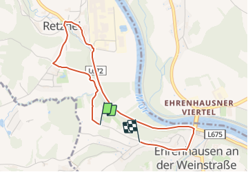
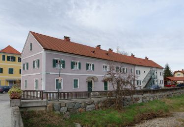
Randonnée A pied de 3,9 km à découvrir à Styrie, Bezirk Leibnitz, Ehrenhausen an der Weinstraße. Cette randonnée est proposée par SityTrail - itinéraires balisés pédestres.
Description
Randonnée créée par Ehrenhausen.
Symbole: weiße Tafel mit grünem Mausoleum-Logo
Localisation
Pays :
Autriche
Région :
Styrie
Département/Province :
Bezirk Leibnitz
Commune :
Ehrenhausen an der Weinstraße
Localité :
Unknown
Départ:(Dec)
Départ:(UTM)
543767 ; 5175133 (33T) N.
Commentaires
Randonnées à proximité
![Randonnée A pied Wagna - Wagna Genussplatzrunde - Photo](https://media.geolcdn.com/t/375/260/2ce7aa19-781f-43fc-b6c8-caa736241160.jpeg&format=jpg&maxdim=2)
![A pied A pied](https://static1.geolcdn.com/sitytour/trail-icons/100.png)
Wagna Genussplatzrunde
A pied
Facile
Wagna,
Styrie,
Bezirk Leibnitz,
Autriche
![](/images/other/stat-length.png)
9,9 km | 10,9 km-effort
2h 28min
![](https://static1.geolcdn.com/siteimages/upload/files/16400158638029165_repeat_loop_refresh_sync_direction_icon.png)
Oui
![Randonnée A pied Ehrenhausen an der Weinstraße - Berghausen 1 - Photo](https://media.geolcdn.com/t/375/260/74815bba-e24d-4ad5-9cfc-9c7a0b388939.jpeg&format=jpg&maxdim=2)
![A pied A pied](https://static1.geolcdn.com/sitytour/trail-icons/100.png)
Berghausen 1
A pied
Facile
Ehrenhausen an der Weinstraße,
Styrie,
Bezirk Leibnitz,
Autriche
![](/images/other/stat-length.png)
7,2 km | 10 km-effort
2h 16min
![](https://static1.geolcdn.com/siteimages/upload/files/16400158638029165_repeat_loop_refresh_sync_direction_icon.png)
Non
![Randonnée A pied Ehrenhausen an der Weinstraße - Ehrenhausen 1 - Photo](https://media.geolcdn.com/t/375/260/4aae38a0-c3b6-4f3a-939c-d40c3c3416c5.jpeg&format=jpg&maxdim=2)
![A pied A pied](https://static1.geolcdn.com/sitytour/trail-icons/100.png)
Ehrenhausen 1
A pied
Facile
Ehrenhausen an der Weinstraße,
Styrie,
Bezirk Leibnitz,
Autriche
![](/images/other/stat-length.png)
13 km | 17,7 km-effort
4h 1min
![](https://static1.geolcdn.com/siteimages/upload/files/16400158638029165_repeat_loop_refresh_sync_direction_icon.png)
Oui
![Randonnée A pied Ehrenhausen an der Weinstraße - Ehrenhausen 4 - Photo](https://media.geolcdn.com/t/375/260/b19dbf09-8ef0-4f6f-bff2-cfaf3f20d6fe.jpeg&format=jpg&maxdim=2)
![A pied A pied](https://static1.geolcdn.com/sitytour/trail-icons/100.png)
Ehrenhausen 4
A pied
Facile
Ehrenhausen an der Weinstraße,
Styrie,
Bezirk Leibnitz,
Autriche
![](/images/other/stat-length.png)
7,5 km | 9,9 km-effort
2h 14min
![](https://static1.geolcdn.com/siteimages/upload/files/16400158638029165_repeat_loop_refresh_sync_direction_icon.png)
Non
![Randonnée A pied Straß in Steiermark - Auen- und Moorwanderweg - Photo](https://media.geolcdn.com/t/375/260/60c16bef-cc0b-4000-ace7-3dd0782ba5b0.jpeg&format=jpg&maxdim=2)
![A pied A pied](https://static1.geolcdn.com/sitytour/trail-icons/100.png)
Auen- und Moorwanderweg
A pied
Facile
Straß in Steiermark,
Styrie,
Bezirk Leibnitz,
Autriche
![](/images/other/stat-length.png)
14,7 km | 15,8 km-effort
3h 35min
![](https://static1.geolcdn.com/siteimages/upload/files/16400158638029165_repeat_loop_refresh_sync_direction_icon.png)
Non
![Randonnée A pied Straß in Steiermark - Rebenwanderweg Spielfeld - Photo](https://media.geolcdn.com/t/375/260/a71392bc-db22-486a-8d6e-d166436c1af8.jpeg&format=jpg&maxdim=2)
![A pied A pied](https://static1.geolcdn.com/sitytour/trail-icons/100.png)
Rebenwanderweg Spielfeld
A pied
Facile
Straß in Steiermark,
Styrie,
Bezirk Leibnitz,
Autriche
![](/images/other/stat-length.png)
10,6 km | 15,5 km-effort
3h 31min
![](https://static1.geolcdn.com/siteimages/upload/files/16400158638029165_repeat_loop_refresh_sync_direction_icon.png)
Oui
![Randonnée A pied Ehrenhausen an der Weinstraße - Natur-Kultur-Archäologie-Weg - Photo](https://media.geolcdn.com/t/375/260/e32fdd88-ded1-4bfe-9de9-de8e0a429387.jpeg&format=jpg&maxdim=2)
![A pied A pied](https://static1.geolcdn.com/sitytour/trail-icons/100.png)
Natur-Kultur-Archäologie-Weg
A pied
Facile
Ehrenhausen an der Weinstraße,
Styrie,
Bezirk Leibnitz,
Autriche
![](/images/other/stat-length.png)
5,8 km | 9,5 km-effort
2h 9min
![](https://static1.geolcdn.com/siteimages/upload/files/16400158638029165_repeat_loop_refresh_sync_direction_icon.png)
Oui
![Randonnée A pied Ehrenhausen an der Weinstraße - Welschlauf Südsteiermark - Photo](https://media.geolcdn.com/t/375/260/19c45851-bd56-49f2-a671-0bafde2a43cb.jpeg&format=jpg&maxdim=2)
![A pied A pied](https://static1.geolcdn.com/sitytour/trail-icons/100.png)
Welschlauf Südsteiermark
A pied
Très difficile
Ehrenhausen an der Weinstraße,
Styrie,
Bezirk Leibnitz,
Autriche
![](/images/other/stat-length.png)
43 km | 58 km-effort
13h 7min
![](https://static1.geolcdn.com/siteimages/upload/files/16400158638029165_repeat_loop_refresh_sync_direction_icon.png)
Non
![Randonnée A pied Leibnitz - Großer Gamlitzer Rundwanderweg - Photo](https://media.geolcdn.com/t/375/260/5a9b458e-bb4b-4b36-87b6-9ad0060c4e79.jpeg&format=jpg&maxdim=2)
![A pied A pied](https://static1.geolcdn.com/sitytour/trail-icons/100.png)
Großer Gamlitzer Rundwanderweg
A pied
Moyen
Leibnitz,
Styrie,
Bezirk Leibnitz,
Autriche
![](/images/other/stat-length.png)
17,8 km | 26 km-effort
5h 52min
![](https://static1.geolcdn.com/siteimages/upload/files/16400158638029165_repeat_loop_refresh_sync_direction_icon.png)
Oui